Apr 07-08

Past-E-Mail: Cam Notes - 2008: April: Apr 07-08
Tunnel under the road    ...scroll down to share comments
Photos by Paul Roberts
Inside the Tunnel    ...scroll down to share comments
Photos by Paul Roberts
View on the other side    ...scroll down to share comments
Photos by Paul Roberts
Zoomed in on an iceberg    ...scroll down to share comments
Photos by Paul Roberts


By
Mary Drew at Pasty Central (Mdrew) on Monday, April 7, 2008 - 12:20 am:

A week ago in the Decade of Pasty Cam slideshow there was a photo from March 30, 2001 featuring a tunnel that runs under M-26 at Great Sand Bay. Charlie mentioned that he'd forgotten about that tunnel (Jon Hopper actually took the photo back then) and said he'd have to go look for it when the snow is gone. That's all the inspiration Paul Roberts needed to run up there (really he drove), and snap a few shots to bring us up to date. You can see from these pictures that there are actually two tunnels and he also included several bonus shots of what you can see looking out from inside those tunnels, toward Lake Superior. The last photo has me wondering, is that an iceberg floating in the Big Lake or is it really a rock formation, covered in ice?


By David Hiltunen (Davidcorrytontn) on Monday, April 7, 2008 - 01:38 am:

It is just the tip of the iceberg,and I am not talking lettuce. I did not know about these tunnels.


By Deb S. (Usedtobeayooper) on Monday, April 7, 2008 - 07:18 am:

Very nice pictures. And to think I never knew that tunnel existed.


By D. Clark (Dcclark) on Monday, April 7, 2008 - 07:25 am:

I think this tunnel is where Owl Creek empties into superior. The creek only flows through one side of it most of the year (and the other side is entirely crawlable!).


By Rowdy (Roudymi) on Monday, April 7, 2008 - 08:30 am:

I figgured dat one side let water out 'n da ottur side let da water in. Vat you tink dat anyvay???


By Richard Johnson (Dick_fl) on Monday, April 7, 2008 - 10:22 am:

Rowdy,
By George I think you've got something there.


By Paul Roberts (Grizzlyadams) on Monday, April 7, 2008 - 10:58 am:

D. Clark,

Entirely crawlable eh? I guess I know what I'll be doing when the snow clears. The only reason I'm not doing it now is that I'm sure I would get hung up at some point due to the depth of the snow back in the bush. It's certianly not a spot where my expensive camera will go! I'll have to use the point and shoot for that! So be watching for pictures from the Owl creek bed sometime soon either here or in my gallery or both! Thanks for the tip! Speaking of tips for those of you who may or may not remember I will be on the hunt this summer for outhouses (not to use them but to photgraph them). I know there are some in Phillipsville and will be heading down that way at some point. If anyone knows where there are more let me know. I'll be on the prowl! :-) (grizzlyadams@pasty.net)


By Gary W. Young (Gary49) on Monday, April 7, 2008 - 12:39 pm:

I'm a old construction worker and this is a picture of a double barrel box culvert. In the summer they are a nice place to cool off if the water isn't to high. Nice pictures!


By D. Clark (Dcclark) on Monday, April 7, 2008 - 01:05 pm:

Paul,

Yup, quite crawlable. I've bushwhacked it up the creek for a while, but it's very dense. I ended coming out on some ski trails in the area and walking back to the road!

By the way, I believe there is an old outhouse along 41 somewhat north of Quincy, on the left (as you head north). It's at an old abandoned house right next to the road.


By Frank Picotte (Frankp) on Monday, April 7, 2008 - 01:18 pm:

does anyonee remember the tunnel we had on M-26 in Lake Linden


By RCW (Rcw) on Monday, April 7, 2008 - 04:21 pm:

I sure do Frank, would be nice to see a photo of that too again, more historic objects of the mining days.


By Ned Aldridge (Nedjames) on Monday, April 7, 2008 - 08:45 pm:

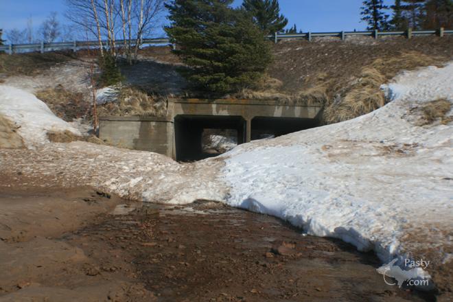
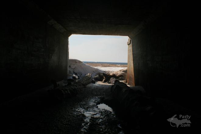
The photo of the box culverts reminded of something which I am sure many folks are not aware of. When my folks first moved to the Copper Country (mid forties), the road along the Great Sand Bay ran along a route that was very close to the beach and much closer to the lake than it does today. If you stand near where the "Public Beach" sign is and look to the west you can see where the road formerly was. What happened was that a big lake storm came up and washed out some sections of the road, so the Keweenaw County Road Commission relocated the road to where it is today. Clem Veale (sp??) was the road commission engineer at that time. Back in the "good" old days.


Powered by:  
Join Today!
Each day the Pasty Cam has 2 areas to post messages: 
  • Cam Notes - comments related to today's picture and discussion
  • What'sUP - other topics, conversation and announcements
  • *** Please use the appropriate forum ***
    Here's a list of messages posted in the past 24 hours
    See our guest photo gallery for more great views from the U.P.

    Add a Message


    A user/password combination is now required to post messages to Cam Notes. Registration is free. Click here to register or maintain your I.D.
    Username:  
    Password:

    Home | Pasty Cam | Contest | Order Now | Bridge Cam | Past-E-Mail | GP Hall of Fame | Making Pasties | Questions