Apr 07-07

Past-E-Mail: Cam Notes - 2007: April: Apr 07-07
Road sign    ...scroll down to share comments
Photos by Z-Man
L'Anse - Pequaming map    ...scroll down to share comments
Map from Z-Man
Forest ahead    ...scroll down to share comments
Photos by Z-Man


By
Mary Drew at Pasty Central (Mdrew) on Saturday, April 7, 2007 - 05:08 am:

Leave it to Z-Man, he always seems to come up with something that we haven't seen on these pages before. This time it's road signs, like the first shot of the Crebassa Memorial Road sign, marking a portion of the highway between L'Anse and Pequaming. Last summer this highway was renamed in honor of the man who is considered the town father of L'Anse, Pierre Crebassa. He is also the man who was instrumental in convincing Father Frederic Baraga to come to the area and start a Catholic mission. I wasn't familiar with the location of this road, so Z-Man supplied us with a map for a visual too.

I'm not certain where exactly the Baraga School Forest sign pictured here, is located, but I do know that the forest is in the Pelkie area. Quite an interesting sign with the top of it representing the portion of the U.P. that borders Lake Superior. It's a good representation too, complete with a covering of snow!


By Dan Baldwin (Dbaldwin) on Saturday, April 7, 2007 - 07:18 am:

Neat photo's, looks like a road trip is in order this spring. I keep watching to see when the roads are clear of snow. Looks like I have to wait a bit.


By Deb S. (Usedtobeayooper) on Saturday, April 7, 2007 - 07:28 am:

I don't think I'd have noticed the shape of that sign if you hadn't pointed it out Mary. Nice pictures. I've only been to the Sand Bay area by boat. I think I'm going to have to take a drive through L'Anse and see what's all out there. It's terrible never to have been there after living there for so long.


By David Hiltunen (Davidcorrytontn) on Saturday, April 7, 2007 - 07:58 am:

I forgot about Pequaming.On the map it looks like a doorknob and Crebassa Memorial Road a fault line.Guess it's one of those places you got to be going there to get there.One way in and out.Thanx Z-Man.


By allen philley (Allen) on Saturday, April 7, 2007 - 08:18 am:

When looking at the above map, or any map. Pequaming always looks to me as if it was an island with fill added to connect to mainland. I wonder how much the lake would have to lower to make it an island? Just a thought.


By Marsha, Genesee/Aura (Marsha) on Saturday, April 7, 2007 - 09:29 am:

Hey, why didn't I take and send in these pictures? Deb, you were in front of my cottage when you were in Sand Bay! Maybe you were one of the infrequent boats I waved at. Pequaming Rd. is the gateway to Silver River Falls (my favorite falls and I've seen many!), Pte. Abbaye, the picturesque Huron Bay Marina, the Indian cemetary with spirit houses at Pinery Lakes and, of course, Pequaming (Henry Ford's company town). You can also go to the mouth of the Huron and see the Huron Island Lighthouse. I can't imagine anyone living on such a desolate rock! Everytime I go to hit "post" I think of a new destination! Wait, don't forget the Aura Fiddlers' Jamboree in July!


By Brian Geshel (Bgeshel) on Saturday, April 7, 2007 - 09:46 am:

Nice information, especially the map. Any chance that someone has the ability to provide a map showing the route between Big Bay and L'anse on the Lakeshore?


By Margaret, Amarillo TX (Margaret) on Saturday, April 7, 2007 - 09:49 am:

Hey, it's trying to get us to remember when July comes around. Snow now, sunshine then.


By Marsha, Genesee/Aura (Marsha) on Saturday, April 7, 2007 - 09:59 am:

I'll be reminding everyone of the Jamboree when it comes near. Good Morning America mentioned there is a town in Michigan called Bunny Run. I saw no such place in my atlas, but, or course, that got me to reading other things in the atlas. I thought I'd heard that Pequaming was once an island. The atlas says it is "a Tombolo, an unusual island that is collected to the mainland by deposited sediment." I'm glad that sediment holds the weight of my car (and the houses along the way)!


By Ken Scheibach (Kscheibach) on Saturday, April 7, 2007 - 10:01 am:

Allen, I've always thought the same. I looked at it on Google Earth and the island part is 50-60 feet above the lake where the land between is only 1-3 feet above Superior. It wouldn't have to rise much to flood the area. Most maps designate it as a swamp area.


By Paul (Grizzlyadams) on Saturday, April 7, 2007 - 10:03 am:

Winter's back! What a beautiful sight! I know I might get stoned for saying that but I love the snow and am happy to see it. I am looking forward to summer though! The snow is still really awesome! Have an excellent day!


By Marsha, Genesee/Aura (Marsha) on Saturday, April 7, 2007 - 10:05 am:

It doesn't seem swampy to me, nor high in the middle.


By Helen (Heleninhubbel) on Saturday, April 7, 2007 - 11:03 am:

Hey Grizzlyadams..........come on by I got lots of stones for you snow lovers!!!

The snow in my driveway is to my knees again ....I could just cry!!! The dogs cannot get out their doors..(they have 2 of them) They cannot even walk in this stuff....sigh.....

Did you see Louies has the big bottle of Coke on sale this week.......5 for $3 I think. Think I'll stock up for a rainy day......I don't usually like the big bottles but they beat being stuck in with none eh!

May all you snow lovers get stuck.....and the rest of us have a good fairy come dig us out....God Bless.....xoxo

Hey did Koski from the big T town make it in ??

Happy Easter...........


By Heikki (Heikki) on Saturday, April 7, 2007 - 01:34 pm:

Looks like an interesting place to visit! Gotta check that out this summer.


By Tom Karjala (Tom) on Saturday, April 7, 2007 - 01:43 pm:

I have driven from Big Bay to L'Anse several times. I left Big Bay and just followed what seemed to be the best of the roads. Much of the trip is just two ruts. But unless you go in spring with the frost heaves it isn't bad. The first time I made the trip about 40 years ago, we took a small winch along just in case we needed. We traveled in a 19 60 Chev Corvair. We made sure we had a full tank of gas. Wish I could remember how long it took. The last time I took the trip the roads seemed better marked to find your way.
Not road signs, just signs of continuous traffic.


By Marianne Y (Marianne) on Saturday, April 7, 2007 - 03:15 pm:

Grizzlyadams/Helen--I was thinking that maybe egging might be more appropriate, considering that it is Easter weekend? Sorry, I couldn't resist that one. :-) Also, Helen, you might stock up on some large bottles of Coke, maybe 5 or 10, but the polycarbonate bottles do not have a very long shelf-life comapared to cans. I stock up on cans when there are good sales, which there often are around here, at least on Coke products.

Seriously, I am confused by the markings on the map. At first, I thought that the very squiggly brown line was the road, but then I saw the straight black line next to it. Now, I am assuming that the black line is the real road, but I don't know what the squiggly brown line is? Is the brown squiggly line an off-road or something? I looked on Google maps and their map/satellite hybrid version. A lot of the area does not have much detail on the satellite version. But, it did look like the black straighter line is the real road.

And, it looked like the area between the mainland and the "island" might have been strip-mined or something, or is otherwise just pure rock with no soil, nothing growing on it? The "island" part does look like it is significantly higher than the connecting part. Capt Paul, can you tell us what is up there? Many thanks, in advance...


By Richard L. Barclay (Notroll) on Saturday, April 7, 2007 - 03:17 pm:

Brian,
There is no road along the lake shore between Big Bay and L'anse The private land of the Huron Mountain Club keeps you well south of the lake. You can get through inland on a couple of different roads, the AAA or Triple A and the Northwest road through Dodge City both connect to the Ford Road that passes through Big Eric Campground and Skanee. The Northwest road brushes the edge of HMC property, you could see their wire not too far in the woods from the road along one of the Salmon Trout branches, but that was long ago when somebody I know slipped under it to fish down to the weir.


By kosk in Toronto (Koskintoronto) on Saturday, April 7, 2007 - 03:27 pm:

No, Helen. Kosk did not make it to the UP this weekend. I hope
that the people who live near Houghton/Hancock were able to
make it to my aunt's 90th birthday party. Checking the weather
news for the past couple of days and perusing the new set of
photos I just received from my daughter who lives just outside
of Ishpeming, I think it's probably a good thing that we didn't
attempt to make it through.

I love today's pictures. L'Anse is my father's "stamping
grounds," and I have lots of family in the area so I am very fond
of that area. We even had family who lived and worked in
Pequaming. My dad's school class planted trees when he was a
boy. Maybe these are the very ones. I'll have to ask him about
it. Last summer my dad and I traveled that road, stopping to
look at the mission churches and the Indian cemetery. As for
Pierre Crebassa, he was familiar to me because I had just
finished reading "Lady Unafraid." Now you've done it. My feet
are itching to be back on the road. One of the things my dad
and I hope to do this summer is to drive the shoreline between
the mouth of the Huron and Big Bay. I can hardly wait!


By Deb S. (Usedtobeayooper) on Saturday, April 7, 2007 - 03:56 pm:

Marsha, That is so cool. I really want to get out that way. Had no idea you were there. I'd like to see the falls that are out there. But no falls are really running very good when we're there in late July or early August. And when we're there for Memorial weekend, we really only have Saturday and Sunday and we like to spend it with my parents.


By Marsha, Genesee/Aura (Marsha) on Saturday, April 7, 2007 - 03:57 pm:

And I'll have to read "Lady Unafraid" again.


By The (Zman) on Saturday, April 7, 2007 - 04:18 pm:

Marianne Y (Marianne) The brown lines on the map are contour lines which show elevation. Elevation is the same along the brown line. The line next to it will be a higher or lower elevation.


By Marianne Y (Marianne) on Saturday, April 7, 2007 - 05:02 pm:

Aah--thank you, Zman! That does make sense. And, thank you for your great pictures! We have never been out that way, yet we always go through L'Anse on the way to Houghton.

When I had maps.google.com map the way from L'Anse to Pequaming, I was surprised that it was not Pequaming, MI, but rather Pequaming, United States. Is it a Native American Reservation, then, like Baraga, or part of Baraga?


By Capt. Paul (Eclogite) on Saturday, April 7, 2007 - 06:36 pm:

Didn't I answer this question a few months ago?? Oh well, here goes again..

Pequaming is a “tied island” that is tied to the mainland by an accumulation of sediment called a tombolo. Tombolos form due to longshore drift, which is when sediment is carried laterally along the shoreline by waves arriving at an angle to shore. An obstruction, such as Pequaming, causes the waves to slow behind the island. When a current slows down, sediment will be deposited, in this case forming the tombolo.

As we entered the current interglacial and the glaciers of the last glacial maximum receded, the water levels of the Great Lakes were much higher. At this time, Pequaming was under water and there was no tombolo. The tombolo formed after the lake level dropped to expose Pequaming and allow it to interfere with longshore drift. What your seeing as a “strip-mine” is actually the beach ridges stacked together to form the tombolo and plants growing on the ridges outlining them. The Dr. and I are going to be in the Keweenaw this July to get some photos and do a little geologic work; I'm sure Pequaming will be one of our stops.

And yes, it wouldn’t take a lot to flood the bridge, which leads me to my next point. Lake Superior is rising on the North shore due to glacial rebound of the entire region, which is pushing the lake closer (and higher) onto the South shore, so someday Pequaming might be an official island once again......


By Marianne Y (Marianne) on Saturday, April 7, 2007 - 08:15 pm:

Thank you very much, Capt Paul! I must have missed your discussion before, as I do not recall it.

I hope that we can get UP there this summer for more than a couple of days so that we can do more exploring!

The Huron Mtn area sounds really interesting, after I read an article about it a while ago in the Detroit Free Press. That is amazing how "exclusive" it is. Oh well, that's one area that we will not get to.


By Marsha, Genesee/Aura (Marsha) on Saturday, April 7, 2007 - 08:42 pm:

Marianne: You can explore the Huron Mt. area, just not the Huron Mt. Club area. You can climb Mt. Arvon, which is 11 inches higher than Mt. Curwood. It's a pretty easy climb.

Deb: Silver River Falls are always running good, even in the heat of the summer! That's when I am there. The aroma of cedar is wonderful and I always imagine the Native American settlers walking the same paths I am walking along the river and the falls.


By FRNash/PHX, AZ (Frnash) on Saturday, April 7, 2007 - 11:21 pm:

Capt. Paul (Eclogite):
"Didn't I answer this question a few months ago?"


Yep, sure did. I knew I'd seen that note before, but my attempt to search for Pequaming this morning using Google Power Search (ahem!) failed to find it.
Finally, using DISCUS Keyword Search on Tombolo tonight yields this:

By Capt. Paul (Eclogite) on Sunday, November 12, 2006 - 09:10 pm:


By Marianne Y (Marianne) on Saturday, April 7, 2007 - 11:54 pm:

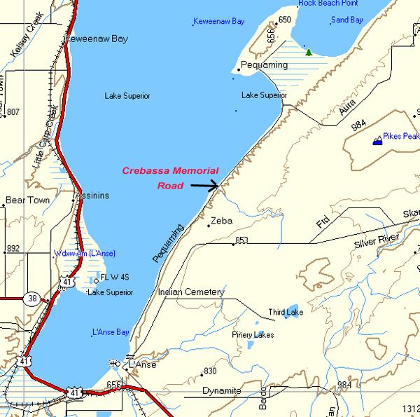
Thanks, Frnash. I found it earlier tonight with my google search for Pequaming, after Capt Paul mentioned having said it before. I had missed Capt Paul's original post, apparently because I had posted quite early in the afternoon that day, and I did not get a chance to check back again, after Capt Paul's post that night. At that time, I did not receive message notification by email, so I was unaware. I'm sorry that I missed his original posting, but I do feel better now that I know how it happened. I sometimes don't get a chance to spend much time with pasty.com on Sundays, and that was a Sunday, I believe.

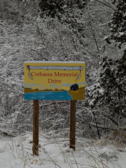
Thank you, again, Capt Paul for answering my question today. Actually, I spent some time researching the area today, after Capt Paul's post this afternoon.


By 4WDGreg (4wdgreg) on Saturday, April 14, 2007 - 11:07 pm:

I love the Indian Cemetery in that area. The Native Americans build those little "houses" on top of the graves and place personal items that their loved ones will need for their journey to the after life. I took a few photos which I should post on Pasty.com. I do wish there were more public access in the Huron Mountains area. I know that the public could responsibly use the area just as we do the Sylvania and McCormick Wilderness areas. I certainly understand the Club members desire to keep the village and their cabins very private.
The area west of the club doesn't seem to have any public waterfront access either, until you get to the Arvon Township park. There are some great waterfalls in that area. Big Erick's Falls and the 40' falls come to mind...
The AAA road is an adventure in itself. The Northwestern is even more of an adventure, and is best left to four wheel drive vehicles.


Powered by:  
Join Today!
Each day the Pasty Cam has 2 areas to post messages: 
  • Cam Notes - comments related to today's picture and discussion
  • What'sUP - other topics, conversation and announcements
  • *** Please use the appropriate forum ***
    Here's a list of messages posted in the past 24 hours
    See our guest photo gallery for more great views from the U.P.

    Add a Message


    A user/password combination is now required to post messages to Cam Notes. Registration is free. Click here to register or maintain your I.D.
    Username:  
    Password:

    Home | Pasty Cam | Contest | Order Now | Bridge Cam | Past-E-Mail | GP Hall of Fame | Making Pasties | Questions