Sep 13-07

Past-E-Mail: Cam Notes - 2007: September: Sep 13-07
Huron Island Lighthouse    ...scroll down to share comments
Photo by Dan Larson
Another view    ...scroll down to share comments
Photo by Dan Larson
Looking up from below    ...scroll down to share comments
Photo by Z-Man


By
Mary Drew at Pasty Central (Mdrew) on Thursday, September 13, 2007 - 04:57 am:

There is no public access to this "off the beaten path" light, unless you head there by boat and even then you better have the right equipment to navigate the shoals and treacherous waters surrounding the spot. Of course you can take in the view of the Huron Island Light Station like Dan Larson did, from the air. Or you could enlist the aid of someone that does know how to get you there, like Z-Man did for the third shot, taken from the ground. This light was originally built in 1868 to serve as a guide between Marquette and Pequaming, along with the L'Anse/Baraga and Houghton/Hancock ports. It's located three miles north of Huron Point and the Huron Mountains and twenty miles east of the Keweenaw Peninsula. Remote is a good word to describe this beacon's location!


By Smfwixom (Trollperson) on Thursday, September 13, 2007 - 06:32 am:

Thanks for the great pictures!


By Marianne Y (Marianne) on Thursday, September 13, 2007 - 06:37 am:

Those are awesome pictures! I am not so sure that I would want to approach that light from below! Talk about rock solid!


By Deb S. (Usedtobeayooper) on Thursday, September 13, 2007 - 07:39 am:

I didn't even know that this one existed. Very nice pictures.


By Keith in Kansas (Keithinks) on Thursday, September 13, 2007 - 08:06 am:

These are great shots! The island is quite a contrast from the sandy beach at the mouth of Huron River which is a spot where you can view it from the shore. http://gallery.pasty.com/keithinks/albuq36/DSC_01880001.JPG.html


By Capt. Paul (Eclogite) on Thursday, September 13, 2007 - 08:07 am:

I've been looking at the first 2 pics and I believe those are 2 different lighthouses/fog signals on the Huron Islands. Take a look at the amount of trees and their location between the photos. Also look at the location of the buildings relative to each other. Nothing like a little mystery first thing on a Thursday morning....

Oh and btw, we felt nothing from Humberto last night. Only thing it did was bring a nice dry morning with low humidity.


By Kathyrn Laughlin (Kathyl) on Thursday, September 13, 2007 - 08:19 am:

Hey Capt. Paul, good eye. I followed the link to the Huron Island Light Station site and they had the following:
"... construction began in 1881 on a pair of fog signal buildings on the west end of the island, approximately 1,700 feet from the lighthouse. "


By Brooke (Lovethekeweenaw) on Thursday, September 13, 2007 - 08:29 am:

Deb, I didn't know it existed either. Its very cool.


By John F.W. Hess (Johnhess) on Thursday, September 13, 2007 - 08:38 am:

If you look closely at the bed rock in front of the light house I believe the grooves (striations) in the rock were formed by the last glacier. They also indicate the direction of the last glacier


By Capt. Paul (Eclogite) on Thursday, September 13, 2007 - 10:59 am:

I had a look at some satellite photos of the Huron Islands. I would tend to believe that while there are probably some glacial grooves on the Islands, I also see a nice joint system that has developed. The joints would be related to events that took place long before the glaicers had any influence on the Islands. I have heard that the rocks on the Islands are granites, but since I have never been out there, I can't say for sure (this may have to be a side trip next year). If they are granite, they are most likely related to the Marquette Range Supergroup granites that are found in the Huron Mountains east of Baraga.


By Richard A. Fields (Cherokeeyooper) on Thursday, September 13, 2007 - 11:11 am:

Ok, so how did the keeper get his supplies up to the lighthouse?


By Marianne Y (Marianne) on Thursday, September 13, 2007 - 11:28 am:

Pack mules (like they do in the Grand Canyon today), block & tackle, pulley systems, inclined planes??? Those would be my guesses, without researching it. Look at Stone Henge in Great Britain--that is a marvel, as are the Pyramids in Egypt. How were those built? They did amazing jobs, especially considering how very long ago they were built. Mankind has often been mighty creative and inventive in the course of history. :-)


By Dr. Nat (Drnat) on Thursday, September 13, 2007 - 12:20 pm:

The Egyptian pyramids probably had a system of internal ramps to help move material. I just read about that in a recent Archaeology Magazine article.

But I have to get back to class now.


By Helen (Heleninhubbel) on Thursday, September 13, 2007 - 01:57 pm:

WOW......there is just so much to learn and so much we will never really know until our creator can answer our questions......but, you guys and girls are really smart.......maybe I should start reading something other than self help eh...????? lol

God Bless all of you out there........hugs


By Marsha, Genesee/Aura (Marsha) on Thursday, September 13, 2007 - 02:23 pm:

This is my favorite lighthouse, and these are wonderfully clear pictures. When I view it from the mouth of the Huron, I can't help but fantasize about what life was like there for a family. I borrowed a Christian romance novel (!) from our church because the title was something to do with Michigan. Although the stories were "light" (really, no pun intended), there was one entitled "Lighthouse" that told of the life of a family in a Michigan lighthouse. It was actually quite interesting, telling of it's maintenance, storms and winters there, and the arrival of supplies below the cliffs.


By Alex J. Tiensivu (Ajtiensivu) on Thursday, September 13, 2007 - 03:41 pm:

Marsha... I am with you in the thought of what it would be like for a family to live there. I would give anything to move there with my family and UNautomate the light and run it myself!


By maija in Commerce Township (Maija) on Thursday, September 13, 2007 - 05:19 pm:

girls?


By Cindy, New Baltimore, MI (Cindy) on Thursday, September 13, 2007 - 06:07 pm:

I love the pictures today. I have visited most of our Michigan lighthouses except for ones that are extremely difficult to access by water. I would love to go out there someday and see this one for myself. What beautiful pictures.


By a m hill (Lvcamnotes) on Thursday, September 13, 2007 - 06:17 pm:

i believe the second picture is not the huron
islands' lighthouse. i was there in 1961 --
uscg was still custodian. my uncle was a
commercial fisherman who tended nets in the
area. he occasionally stopped in at the
lighthouse for a visit and dinner (he was a
uscg officer during ww2 and was welcomed by
the custodian). in the second picture, i can't
recognize the coastline which i would guess to be
the south side of the island where the dock was.
but my memory is foggy nowadays.


By kay Moore (Mskatie) on Thursday, September 13, 2007 - 07:47 pm:

Capt. Paul have a strange question for you of geologic(?) knowledge. Ate at a Chinese resturant today,and it has pictures of those mysterious- shaped mountains. Are those peaks for real? And what is their history and their make up? Paintings of them are so beautiful! Courious Kate.


By Walter P McNew (Waltermcnew) on Thursday, September 13, 2007 - 08:37 pm:

grand pictures i remain walter p.


By PauLinda weluvdaUP (Paulinda) on Thursday, September 13, 2007 - 09:45 pm:

Can anybody tell us if the mine tour for Delaware Mines is
worth the mpney?
Linda and I are planning to go thru next time up there in
May of '08.
Thanks,
PauLinda(weluvdaUP)


By Frederic W. Koski (Fred) on Thursday, September 13, 2007 - 10:15 pm:

Terrific photo's of my favorite Lighthouse!


By Karen W (Norman333) on Friday, September 14, 2007 - 08:03 am:

weluvdaUP: If that is true, anything you choose to do up there is wonderful. And yes, the Delaware Mine tour is really exciting as it is self guided. Gives you a great feel fo the actual job of mining. And.....don't forget to look up, I have never seen so many bats in my life !!


By Capt. Paul (Eclogite) on Friday, September 14, 2007 - 08:24 am:

Anytime one can get underground, especially in the Keweenaw, to see how a mine worked in the 1800's is a real treat. So yes, I believe it is worth going into Delaware. It's not as in-depth as Quincy, but it was also a much smaller operation and mined a different kind of rock.

I know exactly what your talking about MsKatie. Yes, those peaks are for real!! They are located in Guilin, China along the Li River and aren't really known as any particular name, just the Karst Hills. Karst is a geologic term that describes geologic formations subject to forming caves and sink-holes. Limestone and gypsum are typical materials that makeup these kinds of formations. They dissolve easily in water. Over time the ground water will migrate in an underground stream carrying the dissolved material along with it. Eventually caves will form, then sink-holes if the cave ceilings give away. Take this idea to the extreme and you will find that these knobby hills are what is left after so much of the rock has dissolved and been carried away.

For an idea of what I'm talking about....

karst


By RD, Iowa (Rdiowa) on Friday, September 14, 2007 - 08:40 am:

Doesn't look like Mt. Bohemia to me.


By Marianne Y (Marianne) on Friday, September 14, 2007 - 09:31 am:

Capt Paul, those don't necessarily look all that different from the Grand Tetons in Wyoming, except the Grand Tetons have sharp, jagged peaks, for the most part?


By Capt. Paul (Eclogite) on Friday, September 14, 2007 - 10:02 am:

Not particularly different is correct, but they differ greatly in their composition and how they were formed.

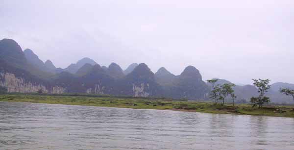
While the Karst Hills in China are formed from dissolution of carbonate rocks (limestones and gypsums), the Tetons were formed from tectonic activities associated with the Laramide orogeny and continuing through recent times. The Teton Range consists of a core of igneous and metamorphic Precambrian rocks overlain in most of the range by westward dipping sedimentary Paleozoic rocks. The sculpturing influence of glacial ice has provided a final spectacular touch to a scene that already boasted mountains rising sharply from a broad, flat valley. However, the Tetons also contain large amounts of limestone and dolomite forming karst. We just don't see the spectacular karst topography that is in China because conditions just didn't favor that kind of development in and around the Tetons....


By Marianne Y (Marianne) on Saturday, September 15, 2007 - 06:53 pm:

Thank you, Capt Paul for your comparison & contrast of the Karst Hills in China vs the Tetons! I appreciate it!


Powered by:  
Join Today!
Each day the Pasty Cam has 2 areas to post messages: 
  • Cam Notes - comments related to today's picture and discussion
  • What'sUP - other topics, conversation and announcements
  • *** Please use the appropriate forum ***
    Here's a list of messages posted in the past 24 hours
    See our guest photo gallery for more great views from the U.P.

    Add a Message


    A user/password combination is now required to post messages to Cam Notes. Registration is free. Click here to register or maintain your I.D.
    Username:  
    Password:

    Home | Pasty Cam | Contest | Order Now | Bridge Cam | Past-E-Mail | GP Hall of Fame | Making Pasties | Questions