May 16-07

Past-E-Mail: Cam Notes - 2007: May: May 16-07
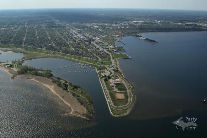
Escanaba    ...scroll down to share comments
Photos by E. Neil Harri
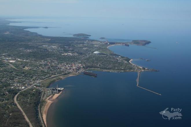
Marquette    ...scroll down to share comments
Photos by E. Neil Harri


By
Mary Drew at Pasty Central (Mdrew) on Wednesday, May 16, 2007 - 06:11 am:

I remember the first time I flew in an airplane, thinking how different everything looked from that high an altitude and actually having trouble picking out where we were, even though I knew the area we were flying over. I'm sure that E. Neil Harri has been flying for enough years that he has no trouble with identifying places like the park and marina at the end of Ludington St. in Escanaba for today's first shot. No matter how many times you've driven down that street, it just looks different from above. Neil takes us over Marquette and its harbor in the second photo, with the ore docks and harbor breakwalls jutting out into Lake Superior. Neil's pictures always give you a feeling of being right up there in the cockpit with him, taking in the beauty of the U.P. from up above.


By RD, Iowa (Rdiowa) on Wednesday, May 16, 2007 - 06:18 am:

Amazing when you look at the horizon on either picture, you can see the curvature of the earth. It really IS round!


By Jeff Kalember (Jeffkal) on Wednesday, May 16, 2007 - 06:20 am:

E. Neil Harri -- I'm wondering if you give out rides for a fee ?? I'll be up in your area in July and would love to see the UP from above...


By Deb S. (Usedtobeayooper) on Wednesday, May 16, 2007 - 07:06 am:

Those are some great looks at two great towns.


By Margaret, Amarillo TX (Margaret) on Wednesday, May 16, 2007 - 07:18 am:

Great aerials Neil.


By Charles In Esky (Charlesinesky) on Wednesday, May 16, 2007 - 08:09 am:

Well,, well, well, what a nice picture of Esky. Thanks! We live
about a block from the park shown in that pic and walk the dog
there each day. He especially likes it when he can romp in the
water off the sand beach shown in the lower left. You can see
Esky's coal and limestone dock in the center upper right. The
ore dock is off the to the right of the picture shown.I enjoyed the
pic of Marquette too. When Marquette folks talk about their
upper and lower harbors, you can see what they mean from this
pic.


By s. dearing (Geebeed) on Wednesday, May 16, 2007 - 08:56 am:

My husband and I spent some time in Marquette last fall. It's very interesting to see this aerial view. Thank you Neil!


By David Hiltunen (Davidcorrytontn) on Wednesday, May 16, 2007 - 09:26 am:

I love the view from the sky.(Geebeed; the last person who told me they spent time in Marquette just got out of Prison.


By s. dearing (Geebeed) on Wednesday, May 16, 2007 - 09:45 am:

Apparently, David, "spending time" in Marquette was not the best choice of phrases. How about we were vacationing in the UP, especially to enjoy the fall colors which were much more vivid and beautiful than where we live.


By Anna Roehrich (Updreamer) on Wednesday, May 16, 2007 - 09:52 am:

I always love the aerial shots, such a unique vantage point. I especially love to see Superior, because of the clarity of the water...you can actually see where the sand drops off. Amazing.


By Marianne Y (Marianne) on Wednesday, May 16, 2007 - 09:59 am:

I always love Neil Harri's aerial photos! Thank you, both Neil & Mary, for two more great aerial views of the UP!

LOL, Geebeed & David when I read your responses! I had forgotten that a big state prison is there, so the line "spending time in Marquette" has a double meaning. That's great, especially on a drizzly, dreary, foggy Wednesday morning here in mid-Michigan!


By Brooke (Lovethekeweenaw) on Wednesday, May 16, 2007 - 10:30 am:

Yet again, two perfect pictures from Neil. He always captures so much.


By Cindy Pihlaja Russell (Gone2long) on Wednesday, May 16, 2007 - 10:39 am:

Fun flies when you're doing time!


By Jeff Kalember (Jeffkal) on Wednesday, May 16, 2007 - 10:44 am:

if you havent seen E. Neil's pics yet check them out ... my fave is his Menagerie Island pic from above. wow. amazing. Its in his folder on page 9 or 10.


By John W Anderson (Wd8rth) on Wednesday, May 16, 2007 - 11:30 am:

Just the other day I was watching "Keweenaw Lights" and "Isle Royle Lights" videos from Keweenaw Video Productions.
Both videos are about lighthouses on Lake Superior and very well done. There in the credits was Pilot: Neil Harri.

73 John WD8RTH


By 69 TOOT (Flyindamooney) on Wednesday, May 16, 2007 - 12:03 pm:

You have to be about 70,000 feet higher to actually see the curvature of the earth, (I am told) ...I have had my little airplane up to 17,500 feet and while impressive, it isn't round yet......camera focal image........I look forward to 4th of July and will be flying in for a couple of days. Always a great time to view the entire area, but especially the big K. See you on the 4th........


By Shirley Milford (Grannymim) on Wednesday, May 16, 2007 - 12:18 pm:

Thanks, Cindy, for your quote - "Fun flies when you're doing time!" I'd never heard that one before and it gave me my biggest laugh of the day....
As always, love E. Neil's pictures.


By Helen (Heleninhubbel) on Wednesday, May 16, 2007 - 12:22 pm:

Ouuuuuuuuu I love the Esca picture I didn't realize it looked like that. Looks like a beach area all by itself......I will have to check it out next time I visit.......Thanks Mr Neil H.


By Helen (Heleninhubbel) on Wednesday, May 16, 2007 - 12:24 pm:

Opps...........what is on that other point sticking out...?????

God Bless all of you.......


By Rowdy (Roudymi) on Wednesday, May 16, 2007 - 12:24 pm:

Neil keeps us on a "higher plane"!


By FRNash/PHX, AZ (Frnash) on Wednesday, May 16, 2007 - 01:20 pm:

69 TOOT (Flyindamooney)
"You have to be about 70,000 feet higher to actually see the curvature of the earth …"


Well, maybe, to see the full curvature of the earth … but you sure can see the arc of the horizon in the first picture above.

In fact, you can even see the curvature of the earth from the ground when looking eastward toward the Great Salt Lake over 70+ miles of Utah's western salt flats from Wendover, UT, and the former Wendover AFB (now Wendover Airport (KENV). — Been there, done that.

Trivia note: Wendover AFB is where Col. Paul W. Tibbets Jr. and the 393rd Bomb Squadron trained before moving to North Field, Tinian, in the Marianas, in final preparation for the bombing of Hiroshima on Aug 6, 1945.

See also: A visit to Wendover Field, where the Enola Gay trained before its secret atomic mission to Japan

(Disclaimer: The above material is not intended to inspire any rancorous debate about the pros and cons of the bombing of Japan, but solely as documentation of an historic fact.)


By John W Anderson (Wd8rth) on Wednesday, May 16, 2007 - 08:16 pm:

hi Helen and everyone else

the land to the left of the harbor mouth is Arnson(sp) island with the beach house near the left center of the picture. on the right of the mouth is sand point. the large building in the middle of the drive is the public water works. near the top is the Sand Point Lighthouse and the Delta County Historical Society Museum, also, there is the municipal marina with there three finger docks.

The next time you are passing thru Escanaba turn east and drive down Ludington street and around Ludington park and Sand point. I think it will be a nice detour.

73 John WD8RTH


By Helen (Heleninhubbel) on Wednesday, May 16, 2007 - 08:59 pm:

Hey John........thanks alot. I will try your Detour. I don't know to much about Esca but there is a resturarant with an old car theme....it is really nice and the food is good.
It's sorta down from the Mazada dealer at the lights on the main drag.

Anyway I can't wait to go down and check it all out.

Again Thanks.....God Bless........Helen


By Charles Pomazal (Cpomazal) on Wednesday, May 16, 2007 - 10:15 pm:

Wow, the lake is down! Aronson's Island isn't so much of a beach as a mud flat.

John W., are you affiliated with the Delta Co. Hist. Society?


By John W Anderson (Wd8rth) on Thursday, May 17, 2007 - 09:32 am:

Morning All .... Helen .. Hudson's Classic Grill is the restaurant you are thinking of. Just a block north of Ludington St. Good food and with a 50's and 60's theme. Charles P. .. I just became a member of the Historical Society this year. If you have question "Charles in Esky" has been with the society longer, he might be able to help.

73 John WD8RTH


By John W Anderson (Wd8rth) on Thursday, May 17, 2007 - 09:40 am:

also, what looks like a mud flats on Aronson's Island is a sandy beach. on the hot day's of summer, people will sun and swim there. No life guards, swim at your own risk. there are life guard at the beach house.

73 John WD8RTH


Powered by:  
Join Today!
Each day the Pasty Cam has 2 areas to post messages: 
  • Cam Notes - comments related to today's picture and discussion
  • What'sUP - other topics, conversation and announcements
  • *** Please use the appropriate forum ***
    Here's a list of messages posted in the past 24 hours
    See our guest photo gallery for more great views from the U.P.

    Add a Message


    A user/password combination is now required to post messages to Cam Notes. Registration is free. Click here to register or maintain your I.D.
    Username:  
    Password:

    Home | Pasty Cam | Contest | Order Now | Bridge Cam | Past-E-Mail | GP Hall of Fame | Making Pasties | Questions