Aug 07-15

Past-E-Mail: Cam Notes - 2015: August: Aug 07-15
Great Sand Bay - 2007    ...scroll down to share comments
Photos by Paul and Nathalie Brandes
Great Sand Bay - 2013    ...scroll down to share comments
Photos by Paul and Nathalie Brandes
Great Sand Bay - 2015    ...scroll down to share comments
Photos by Paul and Nathalie Brandes
Looking up the bay    ...scroll down to share comments
Photos by Paul and Nathalie Brandes
Looking down the bay    ...scroll down to share comments
Photos by Paul and Nathalie Brandes
Erosion near the stairs    ...scroll down to share comments
Photos by Paul and Nathalie Brandes


By
Mary Drew at Pasty Central (Mdrew) on Friday, August 7, 2015 - 10:03 pm:

While here in the Keweenaw, Paul and Nathalie Brandes (alias Capt. Paul and Dr. Nat) stopped off at one of their favorite spots to check out the shoreline and they got quite a surprise. Here's what they had to say about their discovery:

"We were cruising the Keweenaw and decided to visit one of our favorite spots, Great Sand Bay. One of the first things we noticed was “where is the sand…we thought this was called Great Sand Bay for a reason”? We took several shots and once we got back to our cabin, we decided to compare photos from this day, with some previous years’ photos that we have taken. The top photo was taken in 2007 when the beach was all sand; the second photo from 2013 shows where there is very little rock on the beach and still mostly sand, and then the 2015 photos where it is nothing but rock!"

Nathalie (Dr. Nat# gives us an explanation for what is happening on this Lake Superior shoreline: "This is a great example of how coastlines are always changing in response to things like water level, wave action, and storm activity. The lake level seems to be higher right now and erosion appears to be the dominant process occurring. #I haven’t been around to see exactly what storm activity has occurred in the area, what the ice during the winter was like, or other details that might be important to understanding this). The last photo is me standing next to the steps leading down to the beach. The photo shows just how much erosion has taken place since the steps were built. I always teach my students that coasts are dynamic and ever-changing. When I come back next year, I have no doubt it will have changed again; that is the most fascinating aspect of geology and how it evolves over time."
The other interesting item Capt. Paul mentioned, is that they even dug down maybe a foot into the rocks on shore there and still found no sand. So there you have it folks. The Superior shorelines are a'changing and will continue to do so year after year.
By
Deb S. (Usedtobeayooper) on Friday, August 7, 2015 - 10:08 pm:

Wow! We didn't go down so never noticed.
But now that I think about it, I don't
remember seeing the sand. That's sad! I
hope it comes back.


By FRNash/PHX, AZ (Frnash) on Friday, August 7, 2015 - 10:54 pm:

From Mlive.com on August 02, 2014 at 11:32 AM, updated August 02, 2014 at 11:38 AM:
(click →)"Lake Superior water level now highest in 17 years: See the amazing rise in past two years"


By Uncle Chuck (Unclechuck) on Friday, August 7, 2015 - 11:18 pm:

Very interesting!


By Dunerat (Dunerat) on Saturday, August 8, 2015 - 12:29 am:

Great photos and an interesting discussion, Capt. Paul and Dr. Nat, thank you!

It's interesting that your first photo is from 2007, the year of the second lowest levels for Lake Superior since 1918. Only 1926 saw lower water levels. And yes, the level of Lake Superior is the highest it's been in 17 years, but it has seen many periods of even higher water levels.

I live on a dune on Lake Michigan, and I've closely observed water levels and their effect on beach dynamics for the last 20 years.

So where did the sand go at Great Sand Bay if it's not under the shoreline rocks? The most likely answer is that it's offshore. Remember that sand particles have very high surface-area-to-mass ratios compared to pebbles and rocks. It's very easy for them to become suspended in moving water, so waves easily transport sand off beaches when water levels are rising.

The truly fascinating part of this is how sand beaches build when water levels start dropping. Submerged near-shore sand is deposited by wave action just above the waterline. Given a day or two of drying after a windy/wavy period, that sand can be easily moved farther onshore by wind action, via both saltation and creep. It's a fascinating textbook study, but the really remarkable thing is to watch it happen in real life.

We had very high water levels on Lake Michigan in 1997 and our beaches were pretty much nonexistent; the water was lapping at the bases of our big dunes. Lake levels dropped with extraordinary speed beginning in 1998; by fall of that year, Lake Michigan had dropped to long-term average level.

During the next two years, the level dropped even more. First, we had widening beaches that were very flat and not very much higher than the waterline. But a scattering of shoreline plants established on those sand flats. Wind transported more and more sand onto the beach, and it built up wherever the plants cut the ground-level wind velocity enough to drop the sand out of suspension in the air. It was a really odd experience to walk out on those sand flats when the wind was blowing. At anything north of about 15 mph wind speed, there would be a tremendous amount of sand suspended in the air just above the beach, very much like you see snow swirling over the highway on a cold windy day. It stung a little on your exposed feet and shins, but the sensation was also fascinating in its own way. And in the span of just a few months, those micro-dunes of sand that grew downwind of plants quickly grew into hummocks a couple of feet tall.

Over the next 10 years, those sand flats built barrier dunes at least 10 feet high. What an amazing thing to witness over all those years. So...take heart, when the water level drops again, the sand will be back at Great Sand Bay!


By mickill mouse (Ram4) on Saturday, August 8, 2015 - 01:21 am:

very-very interesting. :O)


By Pat & Glenda (Gormfrog) on Saturday, August 8, 2015 - 06:58 am:

It might be slow, but even a turtle makes progress by sticking his head out.


By Alex "UP-Goldwinger" (Alex) on Saturday, August 8, 2015 - 07:31 am:

Still, the sand always finds its way into your swim suit. :-)
Nice pix and I'm sure the weather is a refreshing change for you both.


By Thomas Baird (Thomas) on Saturday, August 8, 2015 - 08:04 am:

It appears scenic in all the pictures.


By Shirley Waggoner (Shirlohio) on Saturday, August 8, 2015 - 10:29 am:

Like others said....interesting.


By jbuck (Jbuck) on Saturday, August 8, 2015 - 06:27 pm:

Thanks Dunerat!

In the 2007 picture there was a lot of exposed sand above the beach. Wondered if stabilization of those higher sandy areas lead to less along the water line.

Back in the early 80's i lived in Muskegon; some friends with a place on Lake Michigan couldn't get house insurance. The water level was so high homes/cottages were falling into the lake on a regular basis due to erosion.


By Dr. Nat (Drnat) on Saturday, August 8, 2015 - 08:27 pm:

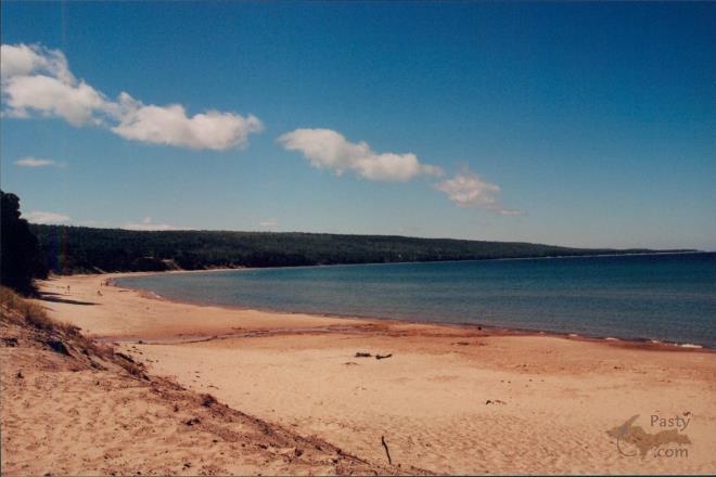
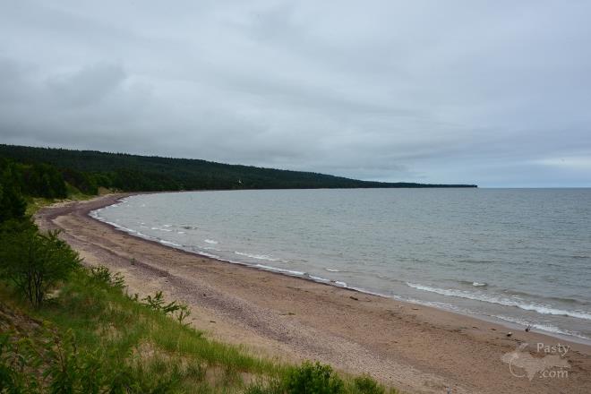
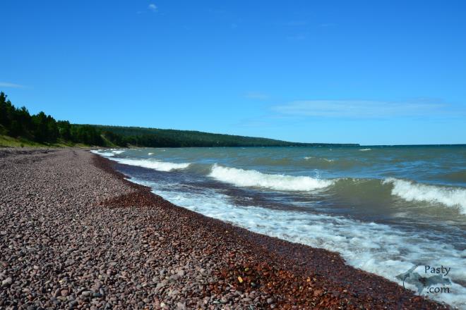
Thanks, Dunerat, for the information you added to the discussion. You described some of the important coastal processes incredibly well. What I see at Great Sand Bay reminds me quite a bit of what sometimes happens along the west coast of North America. During the stormy winter, sandy beaches are often significantly eroded. Once the stormy season is done, those beaches often grow again. I'm sure when I return to the Keweenaw next year, Great Sand Bay will again look different.


By Deb S. (Usedtobeayooper) on Saturday, August 8, 2015 - 11:36 pm:

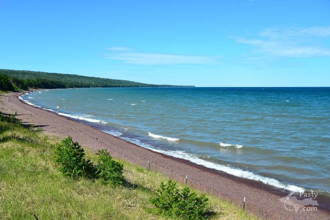
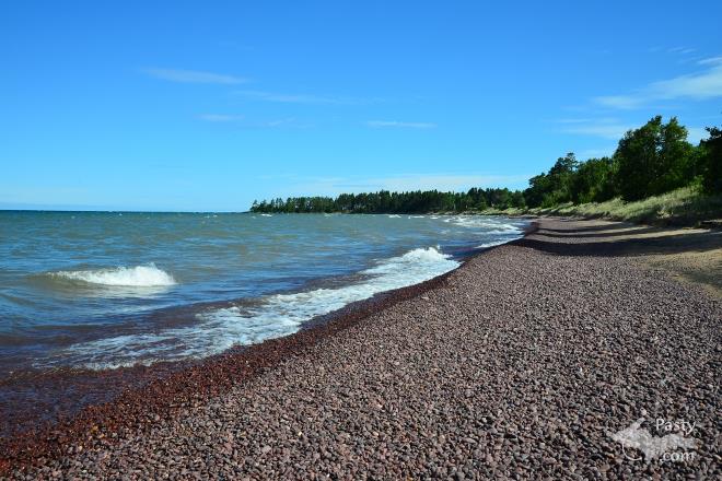
My son's grandparents have a cottage between Gay
and Lac LaBelle, near the Little Betsy River. All
of our younger years and my boy's younger years,
the beach and lake was all wonderful sand. In the
last years, it had turned rocky. Now it is
turning back to sandy again. That lake is large
and in charge.


Powered by:  
Join Today!
Each day the Pasty Cam has 2 areas to post messages: 
  • Cam Notes - comments on today's picture and what's on your mind
  • What'sUP - a view of previous year's and invitation to:
  • Pasty Central's Facebook page
    Here's a list of messages posted in the past 24 hours
    See our guest photo gallery for more great views from the U.P.

    Add a Message


    A user/password combination is now required to post messages to Cam Notes. Registration is free. Click here to register or maintain your I.D.
    Username:  
    Password:

    Home | Pasty Cam | Contest | Order Now | Bridge Cam | Past-E-Mail | GP Hall of Fame | Making Pasties | Questions