Oct 19-05

Past-E-Mail: Cam Notes - 2005: October: Oct 19-05
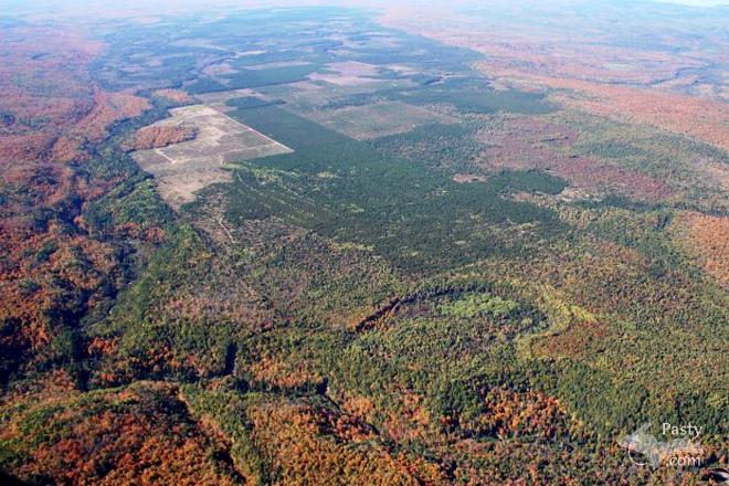
Yellow Dog Plains    ...scroll down to share comments
Photos by E. Neil Harri
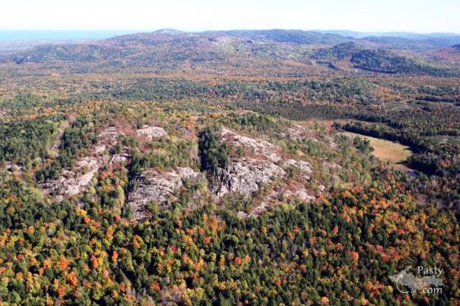
Huron Mountains    ...scroll down to share comments
Photos by E. Neil Harri
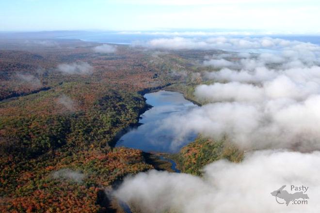
Cloudy Lake of the Clouds    ...scroll down to share comments
Photos by E. Neil Harri


By
Mary Drew at Pasty Central (Mdrew) on Wednesday, October 19, 2005 - 04:03 am:

Pilot Neil Harri, invited us all to join him on a mini-tour of three landmarks in the same number of counties around the U.P. We start out with a flight over Yellow Dog Plains, located in Marquette County. Bonus in that photo is a glimpse of the Yellow Dog River running across the bottom and left side of the image. Then we head west to make a fly-over of the Huron Mountains in Baraga County. Mount Arvon is Michigan's highest point, at 1979 feet and is located in the Huron Mtns., but I'm not sure if it's pictured here or not! To conclude our flight pattern, we head over to Ontonagon County and check out the clouds floating below us. Now we can see with our own eyes, how this picturesque lake acquired its name - Lake of the Clouds! Please put your seats in the upright position and fasten your seat belt, as we make our final descent before landing. Thank you for flying with Pasty.com!


By Brock Waugh (Brock) on Wednesday, October 19, 2005 - 04:32 am:

Well those are great pics. We just finsished our tour of the U.P. and we did see lake of the clouds but seemed to miss those other spots. Just have to see them next time we go there. Also want to thank our new friends Nate and Hillary for a wonderful time thanks guys from us both. Hi Debra. Have a great day everyone


By chris kramer (Chktraprock) on Wednesday, October 19, 2005 - 05:48 am:

Beautiful pictures!!Thanks for sharing more of the great scenery right beneath our wings. It's like a tour of virtual reality and is breath taking just like we're seeing it all through Neil's eyes and sitting as a copilot.


By Smfwixom (Trollperson) on Wednesday, October 19, 2005 - 06:16 am:

Thanks for the great pictures!


By Mike B. Wishin I was back in the Yoop (Mikeb) on Wednesday, October 19, 2005 - 06:23 am:

That middle picture looks alot like Silver Mountain with it's bald top. I believe that is part of the Huron Range. Can anyone verify?


By Margaret, Amarillo TX (Margaret) on Wednesday, October 19, 2005 - 06:59 am:

Even with the clouds, these are great pictures.


By Nate (Nalwine) on Wednesday, October 19, 2005 - 07:28 am:

Brock & Deb--

It was great getting to meet you guys. Hopefully you have a winter trip planned this way and we can try sledding down our hill (or kayak sledding for that matter) I'll make sure Justin comes to visit so we can play more cards too considering his love for the game.


By shawn (Twoyoopers) on Wednesday, October 19, 2005 - 07:57 am:

on the yd pic, does anyone know what that clear cut, scrubbed piece of what might be a 40 ac. parcel, is? Is it from Kennecott? I noticed what appears to be close proximity to a river, possibly salmon trout river which is exactly where Kennecott is test drilling and leaving large, smelly, open pits, but I haven't been up there since last year.


By Leslie at the Northern Lights Lodge (Leslie) on Wednesday, October 19, 2005 - 07:59 am:

Good Morning and thanks for the great photos this morning!

We would like to go camping next summer in the Huron Mountains and would like to know more about that area. Is there a campground? Is there someone that we can contact for more information?


By maija in Commerce Township (Maija) on Wednesday, October 19, 2005 - 08:01 am:

Great pictures, Neil, especially the clouds. Middle one is fascinating. On the ground those would be huge trees. From the air, looks like a tweed carpet.


By Bob Gilreath (Bobg) on Wednesday, October 19, 2005 - 08:11 am:

Leslie,
nice little campground at Big Eric's bridge.

great shots this morning


By Debra J McCumber (Debrajean) on Wednesday, October 19, 2005 - 08:13 am:

Good morning everyone! I see my fiance already posted something up above (Brock), but I just wanted to reiterate what a wonderful time we had this past week in the U.P. We went all the way from White Fish Point to Copper Harbor, Lake of the Clouds, Piers Gorge and many places in between. The colors are breathtaking and the scenery is undescribable. We took 13 rolls of pictures so once we get them developed I will post them in my Pasty Cam Photo Gallery for all to see. We were both sad to come back to trollville, but it's only a matter of time before we move up there to stay. Our plan is to get married up on Brockway Mountain next May or June. And thank you (again) to Nate and Hilarie - you made our stay just that much more special. Have a great day everyone!


By JOHN AND ANNE KENTUCKY (Username) on Wednesday, October 19, 2005 - 08:34 am:

I love the aerial pics that pasty cam gets. Does anybody know of a aerial tour of keweenaw on dvd? I have seen them for other parts of the country. Thanks


By WishingIWasInDaUP (Sur5er) on Wednesday, October 19, 2005 - 08:52 am:

Wow, is that the way to view da UP, or what? Thanks Mary for the guided tour ;)


By Justin Johnson (Tinksno) on Wednesday, October 19, 2005 - 08:56 am:

Can you access the plains off the Blind 35?


By Charles in Adrian (Charlesinadrian) on Wednesday, October 19, 2005 - 09:53 am:

Wow! Just last week I wrote a note here about this wilderness
stream I had never heard of. the Yellow Dog, and Mary comes up
with a pic of the river. Thanks! Another person asked about
camp sites, and the cool book I found last week which describes
this area, "Hiking Michigan's Upper Peninsula," mentionsBig
Eric's State Forest Campground as 14 miles northwest of the
trailhead into the Falls of the Yellow Dog. That campground has
20 campsites the author, Eric Hansen, says.


By E Neil Harri (Ilmayski) on Wednesday, October 19, 2005 - 10:04 am:

The Huron Mt pic shows the montain I know as Bald Knob. Mt Arvon is a few miles SW or behind me as that pic was taken.Mt Arvon is the tallest but is not as photogenic. It looks like a common hill with hardwood trees on top.
The Yellow Dog plains have a lot of connifer plantations on them. Some areas are always being clearcut and replanted. It is mostly owned by a few companies and maintained as tree farms. Access to plains is via Hwy 510. You can access 510 from just East of old Marquette airport on Midway Drive or drive to Big Bay. Bring a map as roads are not signed very well.Good blueberry country.


By Clyde Elmblad (Clyde) on Wednesday, October 19, 2005 - 10:06 am:

The aerial pictures look great!

Leslie...The person in Baraga County to talk to about camping in the Huron Mountains is Tracey Barrett at the Baraga County Tourist and Recreation Association at (906) 524-7444. The association's website is below.
http://www.baragacountytourism.com/

Another contact for Baraga County outdoor recreation information is Steve and Anne Koski at Indian Country Sports.
http://www.indiancountrysports.com/

I hope this helps.


By JoAnne, Washington State (Davejostef) on Wednesday, October 19, 2005 - 10:12 am:

Sure do appreciate all the lovely Fall photos on this site. Year 'round, the pictures are always fantastic but Fall always stands out for me. Having moved from Calumet in '84, I've missed the Fall color. Here in Washington state, there's very little color (guess it's called the Evergreen state for a reason!) so seeing these photos really gets me my "color fix"! Thanks for all your efforts in bringing these pictures to us every day!


By Marsha, Genesee/Aura (Marsha) on Wednesday, October 19, 2005 - 10:27 am:

We camped at Big Eric's in the seventies in our little 13 foot trailer. Those were the days! Also remember camping with our 5 kids later (in a bigger trailer!). A waterfall flows through the campground. Another nearby campground is at the mouth of the Huron, I think on state land. There are no amenities there. The Huron Islands and lighthouse are very close, and the view is amazing! Beautiful, pristine sand beach. This is primitive camping at its best! Neither campground is in the mountains, but very close to the trail up Mt. Arvon. As said above, Tracey at Baraga County Tourist & Rec can give you info on the area. I know there are good websites with info, too.


By Ms. Katie (Mskatie) on Wednesday, October 19, 2005 - 11:43 am:

Aren't the views gorgeous,a "God's Eye View"! The artist that I studied with a week or so ago, paints from her home area near Big Bay, And Yellow Dog River was mentioned . Her name is Nita Engle, a marvelous talent and a spunky older lady, my kind of person.


By Capt. Paul & Dr. Nat in Texas (Eclogite) on Wednesday, October 19, 2005 - 12:18 pm:

Mining companies (and exploration geologists) do not leave large smelly open pits when exploring for minerals! The holes are small (less than 3 inches in diameter) and hardly noticable unless you're specifically looking for them. The open clear cut areas you see in the first picture are from logging companies, which in my opinion, pose a much bigger threat to the environment and tourism of the UP than anything Kennecott will produce.


By fy1 (Formeryooper1) on Wednesday, October 19, 2005 - 12:58 pm:

Logging is no more a threat than mining, it's the abuses that are the problem. And once again, it's private property. The owners have the right to use it in any legal way.


By Alex J. Tiensivu (Ajtiensivu) on Wednesday, October 19, 2005 - 01:26 pm:

This is rare... I caught the bridge up on the cam today!

Going UP!

By
Donald R. Elzinga (Donagain) on Wednesday, October 19, 2005 - 01:33 pm:

The view of Yellow Dog Plains has some great detail. You can see the Salmon Trout River in the upper right and I think even Ives Lake. In the lower left is the small creek in the deep canyon that comes down from Mulligan plains, entering the Yellow Dog close to Pinacle Falls. The logging of jack pine and the occaisional fire have made one of the best blueberry patches in the UP. The history of European settlement in the UP is almost entirely that of the logging and mining industries! That is part of what makes us a unique place. There is legitamate concern about "possible" contamination from sulfide mining. Ms. Katie what is this stuff about "spunky older lady"? Nita was my young neighbor in 1934, and I am not old (I seldom look in mirrors.)


By Chris Beaudoin (Dunerat) on Wednesday, October 19, 2005 - 01:42 pm:

I agree with E Neil Harri on the identity of the rock-topped mountain in the middle photo as Bald Knob or Bald Mountain. Immediately to the right of it is a tan area that was an open-water beaver pond in the early 1980's. I heard the state blew the dam to locate a survey marker that had been flooded.

Follow the tan area up and to the left a little in the photo, and you'll see a patch of dark-green trees, which is an awesome cedar swamp that hugs the southeast corner of the mountain. My dog and I spent a delightful October afternoon in there, jumping from one drowned log and root tangle to the next as we made our way to the mountain.

I used to go back into that area from the two-tracks near Big Erik's Bridge.

The Huron Mountains of Huron Mountain Club fame are in the background at the top of the photo, which has you looking pretty much east.


By Capt. Paul & Dr. Nat in Texas (Eclogite) on Wednesday, October 19, 2005 - 02:06 pm:

I agree with the past posts completely. It is the abuse, not the practice, that has given both industries a bad rap. Please don't get me wrong from my last post, I am not against logging, just clearcutting, and I'm not against "responsible" mining either. Without mining AND logging, the UP would not have the rich heritage it is has.


By Leslie at the Northern Lights Lodge (Leslie) on Wednesday, October 19, 2005 - 02:21 pm:

Gee, thanks everyone for all your suggestions and information! :) We appreciate all your help.


By Richard L. Barclay (Notroll) on Wednesday, October 19, 2005 - 03:53 pm:

There are two main roads across and around the plains area. The one across the plains is County Road AAA and the one skirting the plains to the north is the Northwest road which runs through the old Northwest logging camp. That area is now known as Dodge City. Coming off County Road 550 onto County Road 510 about 2 1/2 miles before Big Bay you'd travel just over 3 miles to the junction of AAA (Triple A.) Three miles on AAA brings you to the y with Northwest road to the right and AAA continuing on the left. Following AAA for about 11 miles will get you to the old Anderson Homestead where you'd take a right onto the old Ford Road which eventually gets you to Big Erick's Campground and beyond. It's about 4-3/4 miles from Andersons to the other end of the Northwest road. If you don't turn onto the Ford road at Anderson's Homestead you wind up past the cut off to the old Panorama fire tower and there are trails through to the Peshekee/Huron Bay grade but some of it winds through swamps with corduroy roads and it's best to be prepared for whatever the woods' gods put in your way.
Have Fun!


By JAD, Oscar, MI (Jandalq) on Wednesday, October 19, 2005 - 04:02 pm:

I nominate the Huron Mt. pic for the 2006 calendar. What could be more typical of the UP? ! ? Makes me think of a Troll colleague who complained about M95 and the Covington Road, "There's nothing there but trees!" and the visiting Pennsylvanian who stood on the shores of The Big Lake and commented, "I don't see anything except water." Oh my. Thank you, Neil, from your Suomi Ethical Problems teacher and librarian.


By shawn (Twoyoopers) on Wednesday, October 19, 2005 - 04:07 pm:

ok capt paul,
how did those smelly pits get there then? We have been told the pits are there from drill bit cleaning, and it stinks to high heaven. I have images of the pits and the test drilling, less than a half mile from the salmon trout river. We saw them with our own eyes test drilling. Sulfide mining is completely different than the mining that built the UP. If you want to continue further, we should probably discuss via email.

Editor's note: Good suggestion, continuing that particular discussion, via personal email would be greatly appreciated! Thank you! :->


By Erica - Florida Keys (Erica) on Wednesday, October 19, 2005 - 09:38 pm:

As usual,spectacular pictures of a spectacular section of our country!


By Lee Wernholm (Leeforfree) on Friday, September 8, 2006 - 09:54 am:

Beautiful pictures - and again, not to nit-pick, but entire scene in the Huron Mountains picture (Bald Mountain and points to the east) is in Marquette County, not Baraga County.


By FRNash/PHX, AZ (Frnash) on Friday, September 8, 2006 - 11:43 am:

Yep, the Baraga county line is just a little more than a quarter mile west of the top o' Bald Mountain, and the heart of the HMC is about 8 miles due east - along the Pine River between Pine Lake and Superior - just to the left of the tallest bump (Huron Mountain) on the horizon in the picture!


Powered by:  
Join Today!
Each day the Pasty Cam has 2 areas to post messages: 
  • Cam Notes - comments related to today's picture and discussion
  • What'sUP - other topics, conversation and announcements
  • *** Please use the appropriate forum ***
    Here's a list of messages posted in the past 24 hours
    See our guest photo gallery for more great views from the U.P.

    Add a Message


    A user/password combination is now required to post messages to Cam Notes. Registration is free. Click here to register or maintain your I.D.
    Username:  
    Password:

    Home | Pasty Cam | Contest | Order Now | Bridge Cam | Past-E-Mail | GP Hall of Fame | Making Pasties | Questions