Oct 16-05

Past-E-Mail: Cam Notes - 2005: October: Oct 16-05
Exploring Keweenaw    ...scroll down to share comments
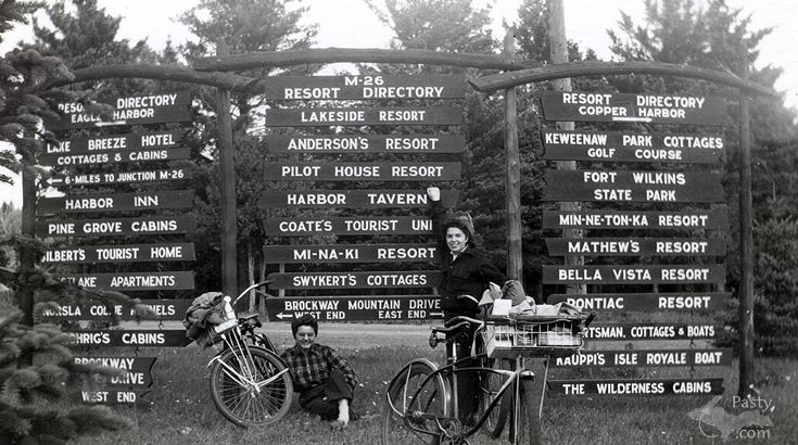
Photo from Richard Barclay


By
Charlie at Pasty Central (Chopper) on Sunday, October 16, 2005 - 08:34 am:

Betty Hainault and Rosella Lence are identified as the young ladies in this shot from September of 1949. Looks like they're loaded with provisions for the trip to Copper Harbor. Browsing the Guest Gallery this morning I re-visited Richard Barclay's album, and was fascinated by the names on the sign... some businesses active to this day, others just a memory. I would like to know just where this was (is?) located.

This weekend I'm finishing preparations for a presentation tomorrow at the "U.P. Cool Summit" in Marquette. I'll be joining a panel at the noon luncheon, with a visual review of Pasty.NET's Brockway Mountain broadband relay, which has an important part in bringing the Pasty Cam to you each day (it's how I connect to the 'net). Colors on Brockway were slow to change this year, but have remained quite beautiful just a little longer. If you're out in the Keweenaw this weekend, I'm sure it would be a worthwhile drive. And... what do you know... gas prices have eased a bit.

Have a good week :o)


By Vincent Vega (Theoneandonlykâ) on Sunday, October 16, 2005 - 08:42 am:

This sign "appears" to be on the corner of US 41 & the Eagle Harbor "shortcut" Road.


By E Neil Harri (Ilmayski) on Sunday, October 16, 2005 - 09:02 am:

This pic has to be in Esrey or Hebbard Park


By Vincent Vega (Theoneandonlykâ) on Sunday, October 16, 2005 - 09:15 am:

Aaah....but how could that be my friend, Mr Harri ? When if you look at the third sign down, on the left, it says "six miles to junction M 26" with a left arrow, when in fact both parks you mentioned are on M 26.


By Cindy Lee Maki (Cindylee) on Sunday, October 16, 2005 - 09:17 am:

I agree with Neil.


By Ahmeek_Native (Ahmeek_native) on Sunday, October 16, 2005 - 09:34 am:

Vincent is right, it has to be at the junction of US41 and the Eagle Harbor Shortcut. Based on the directional arrows and the fact that the junction to M26 is 6 miles. (The approximate length of the Eagle Harbor Shortcut).


By RD, Iowa (Rdiowa) on Sunday, October 16, 2005 - 12:32 pm:

How can it be on US-41, when the bottom of the sign indicates the east and west end of Brockway Mountain Drive are in opposite directions? It clearly must be between Eagle Harbor and Copper Harbor on M-26. Perhaps near Agate Harbor?


By Gordon Schmitt (Gordy) on Sunday, October 16, 2005 - 01:09 pm:

If you look at the sign, the very bottom sign on the left is for the west end of the Brockway Mountain drive


By Ahmeek_Native (Ahmeek_native) on Sunday, October 16, 2005 - 01:11 pm:

No, because if you take the Eagle Harbor Shortcut to Eagle Harbor, then go North on M26 you will get to the West end of Brockway Mountain Drive...if you continue north on US41 and enter Copper Harbor, you are at the East end of Brockway Mountain Drive.

That is how the directional arrows of the signs line up, if it was on M26 near Agate Harbor, the arrows would have to be reversed.


By elm (Grampy) on Sunday, October 16, 2005 - 01:26 pm:

It's on the corner of the Eagle Harbor cut off Rd. The sign says 6 mi to M26 Junction which is about right for getting from 41 to 26 on that rd.


By Mel, Kansas (Mehollop) on Sunday, October 16, 2005 - 01:49 pm:

Perhaps on *top* of Brockway?

Probably not, but it is a thought!


By Margaret, Amarillo TX (Margaret) on Sunday, October 16, 2005 - 02:24 pm:

Very interesting!


By Daveofmohawk (Daveofmohawk) on Sunday, October 16, 2005 - 02:39 pm:

I remember the sign well; it was at the junction of U.S. 41 and the Lac La Belle road. Notice Andersons resort is mentioned which is now Lac La Belle Lodge.


By Charlie at Pasty Central (Chopper) on Sunday, October 16, 2005 - 03:38 pm:

Greetings from the top of Brockway. I happen to be here working on our link back to Mt. Horace Greeley, which serves the Pasty.NET Keweenaw Broadband network. Users in Copper Harbor, Eagle Harbor, Eagle River, and Agate Harbor should find that their speed has returned to normal.

I passed the spot where the sign above used to be, on the way here. I believe it is in fact at the junction of US-41 and the Eagle Harbor cut through. The only thing that bothered me was the road behind the sign in the picture. The intersection in question has a seperate road which forms a triangle with US-41. thus the photographer is standing on one leg of the triangle, the other leg is behind it, and the last leg (US-41) is to the right of the photographer. All of the arrows and mileages fit.


By Daveofmohawk (Daveofmohawk) on Sunday, October 16, 2005 - 04:06 pm:

The one thing that puzzles me is the Anderson's Resosrt sign? Anderson's Resort was owned and operated in Lac La Belle by Jake Anderson; unless there was another Anderson's Resort?


By Helen (Heleninhubbel) on Sunday, October 16, 2005 - 06:41 pm:

Ahhhhhhhhh to have lived here then......what a different life than city life. It always amazes me the business' and people that lived here....It must have been a great place to grow up.....


By Butch (Butch) on Sunday, October 16, 2005 - 08:25 pm:

Google maps has an good image of the triangle intersection Charlie mentioned.Zoom in all the way to see the triangle.


By Richard L. Barclay (Notroll) on Sunday, October 16, 2005 - 08:37 pm:

Sorry I'm late weighing in here, we just made the trip back south to the Flint area today. My mother-in-law (the woman standing) said she and her friends rode their bikes up US-41 to Copper Harbor. They started their trip in the Lake Linden and Hubbell area. It was a last get together with the girls as Betty got married shortly thereafter. I do believe Charlie is right about it being US-41 and the cross-cut to Eagle Harbor.


By Charlie at Pasty Central (Chopper) on Sunday, October 16, 2005 - 09:40 pm:

Richard,

Was it your mother-in-law who appeared a little over a year ago on the Pasty Cam?

Lady in wading

By
WishingIWasInDaUP (Sur5er) on Monday, October 17, 2005 - 04:48 am:

Here is it. Just keep panning West a couple of times...and then South once, until you come to Phoenix. I was thinking that it was at Old 41. But the junction at Phoenix explains different arrows for the West End and East End of Brockway.

www.mapquest.com

Enter the address of 11627 Superior St., Lac La Belle, MI 49950 (Lac La Belle Lodge)...and then pan west a couple of times, and south...tracking route 41.


By Julwisc (Julwisc) on Monday, October 17, 2005 - 10:47 am:

I believe the sign was at the intersection of Hwy 41 and the Eagle Harbor Cutoff Road, which is lately referred to as the Eagle Harbor Road. However, I've noted that the Eagle Harbor Road is sometimes referred to as part of Brockway Mountain Drive on earlier maps.


By Richard L. Barclay (Notroll) on Monday, October 17, 2005 - 01:05 pm:

Charlie,
Yes to the mother-in-law question, also on the same topic my wife just talked to Laura or Jake Anderson and says:
There was an Anderson's resort run by George Anderson in the 40's and 50s. It's now called Eagle Resort and Lakeside Cabins on M26 outside of Copper Harbor.


Powered by:  
Join Today!
Each day the Pasty Cam has 2 areas to post messages: 
  • Cam Notes - comments related to today's picture and discussion
  • What'sUP - other topics, conversation and announcements
  • *** Please use the appropriate forum ***
    Here's a list of messages posted in the past 24 hours
    See our guest photo gallery for more great views from the U.P.

    Add a Message


    A user/password combination is now required to post messages to Cam Notes. Registration is free. Click here to register or maintain your I.D.
    Username:  
    Password:

    Home | Pasty Cam | Contest | Order Now | Bridge Cam | Past-E-Mail | GP Hall of Fame | Making Pasties | Questions