Aug 19-09

Past-E-Mail: Cam Notes - 2009: August: Aug 19-09
Manabezho Falls    ...scroll down to share comments
Photos by Gary Wood
River bottom potholes    ...scroll down to share comments
Photos by Gary Wood
Lake of the Clouds    ...scroll down to share comments
Photos by Gary Wood


By
Mary Drew at Pasty Central (Mdrew) on Wednesday, August 19, 2009 - 07:53 pm:

One of our regular viewers, Lisa Rowan (sisugirl), emailed me about a recent visit she and friends, Craig Spirko and Gary Wood made to the Porcupine Mountains. She said they took over 1700 photos, most of them (including the three we're featuring today) courtesy of Gary Wood. Lisa added some background for each photo, making my job today, quite easy:

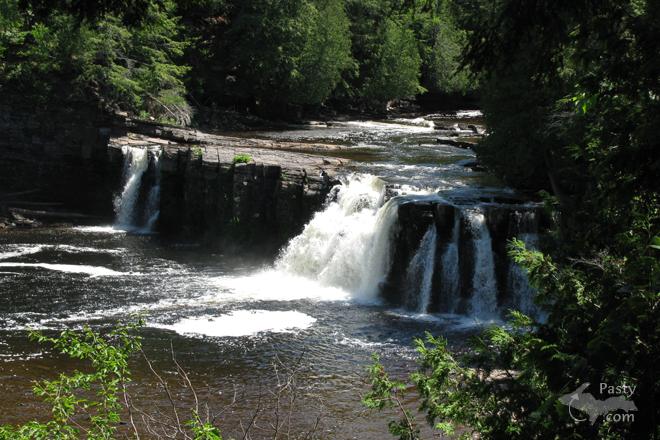
Manabezho Falls, Presque Isle River, western end of Porcupine Mountains State Park - The Presque Isle River is located on the western edge of Porcupine Mountains State Park. According to park signs posted, Manabezho falls is the largest, most powerful falls on the river and hence, the Ojibwa gave it the name of the powerful Ojibwa spirit god, Manabezho.

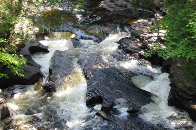
Presque Isle River bottom with "potholes" - The terraced rock over which the Presque Isle River flows is called the Nonesuch Shale. The potholes were formed in places where the eddy current continually swirled pebbles and sand grains in a circular path, scouring the shale to create the holes.

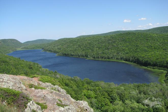
Lake of the Clouds, eastern end of Porcupine Mountains State Park - Lake of the Clouds is located near the eastern edge of the Porcupine Mountains State Park. It rests below an escarpment of basalt and conglomerate, an extension of the same spine that forms the back of the Keweenaw peninsula.
Our thanks to Gary for snapping the shots and to Lisa for being the "go-between" to share them with us.
By
Richard L. Barclay (Notroll) on Wednesday, August 19, 2009 - 08:45 pm:

The potholes look like somebody pushed cookie cutters into the riverbed. Nice. Amazing what the forces of nature can do.


By Capt. Paul (Eclogite) on Wednesday, August 19, 2009 - 09:39 pm:

I hate to be the bearer of bad news Lisa/Mary, but the geologic information is slightly incorrect. You have that the escarpment that makes up the overlook at Lake of the Clouds is the same formation as the spine of the Keweenaw Peninsula. Actually, the spine of the Keweenaw Peninsula is made up of the Greenstone Flow, which is a part of the Portage Lake Volcanics. The Greenstone Flow extends south to Ontonagon County, but passes to the south of the Porcupine Mountains through Mass City/Rockland and over to Copper Peak and beyond into Wisconsin. The rocks you are seeing in the Porkies are of the Copper Harbour Conglomerate and basalt flows called the Lakeshore Traps which are associated with a last pulse of eruptive activity between periods of sedimentation. Below is the geologic map of Michigan and a great little pdf from the DNR on the geology of the Porcupine Mountains.

http://geology.about.com/library/bl/maps/n_statemap_MI2000.htm
http://www.michigandnr.com/publications/pdfs/edopps/PMGEO.pdf

On the other hand, your description of the potholes is spot on!! Those are great photos of potholes too; they really show how they are formed. Beautiful photos today....


By Richard Staszewski (Staszski) on Thursday, August 20, 2009 - 03:59 am:

Oh my! The Porcupine Mountains have to be my favorite place in the whole wide world. I have been going there since about 1974 when I discovered them while riding my motorcyle with my girlfriend (now my sweet wife). Wow those pictures bring back many memories. I am torn between telling people here in Wisconsin about the rugged beauty of the UP and keep quiet so that the pristine silence will not be broken by "more visitors". If I can figure out how to post pictures of the UP and the Porkies, I will so all of you can see. In the mean time, I will be there in Sept. to record the fall colors.


By mickill mouse (Ram4) on Thursday, August 20, 2009 - 06:04 am:

My first trip to Porcupine Mountains, we saw a bear and it was close to the truck you could hear it pulling the grass out of the ground and eating it.


By Alex "UP-Goldwinger" (Alex) on Thursday, August 20, 2009 - 07:36 am:

It doesn't get much better than that!


By Marianne Y (Marianne) on Thursday, August 20, 2009 - 07:46 am:

Those are gorgeous pictures, particularly the ones of the falls & the river! :-)


By Janie T. (Bobbysgirl) on Thursday, August 20, 2009 - 08:18 am:

When Pasty Cam features pictures/places such as these, I use them as a "see and do" vacation planner for our vacatons UP there.


By Alex "UP-Goldwinger" (Alex) on Thursday, August 20, 2009 - 09:08 am:

Janie T...if you have not been to Porcupine Mountains, I highly recommend it. All of the places above are accessible by motorcycle and the roads are all paved and in good condition. You will have to do a little hiking in order to reach the falls. Stop at the visitors center for lots of good park information and be ready to spend an entire day there, at least.


By Janie T. (Bobbysgirl) on Thursday, August 20, 2009 - 09:17 am:

Alex...Thankyou! The Porkies. Our first trip and most impressionable time was in the winter by our snowmobiles...a real wintertime treasure!


By Thomas Baird (Thomas) on Thursday, August 20, 2009 - 11:26 am:

Beautiful waterfall photos. The Porcupine Mountain region is 1 of the U.P.'s most scenic areas.


Powered by:  
Join Today!
Each day the Pasty Cam has 2 areas to post messages: 
  • Cam Notes - comments related to today's picture and discussion
  • What'sUP - other topics, conversation and announcements
  • *** Please use the appropriate forum ***
    Here's a list of messages posted in the past 24 hours
    See our guest photo gallery for more great views from the U.P.

    Add a Message


    A user/password combination is now required to post messages to Cam Notes. Registration is free. Click here to register or maintain your I.D.
    Username:  
    Password:

    Home | Pasty Cam | Contest | Order Now | Bridge Cam | Past-E-Mail | GP Hall of Fame | Making Pasties | Questions