Oct 08-08

Past-E-Mail: Cam Notes - 2008: October: Oct 08-08
Breakfast Lake    ...scroll down to share comments
Photos by E. Neil Harri
Lake Addie    ...scroll down to share comments
Photos by E. Neil Harri
Pond on Montreal River    ...scroll down to share comments
Photos by E. Neil Harri
Location of the Lakes    ...scroll down to share comments
Powered by Google Maps


By
Mary Drew at Pasty Central (Mdrew) on Wednesday, October 8, 2008 - 06:09 am:

Unless you're new to the Pasty Cam, you're already familiar with the aerial photography of pilot, E. Neil Harri. Today he takes us over three bodies of water located on the tip of the Keweenaw. The first one is Breakfast Lake, the second is Lake Addie and the third is a pond that is upstream from the mouth of the Montreal River. I've included a map to show you where these bodies of water are located. The pond location is just a guess on the map though, so correct me if that's not the right location I've indicated for it. Along with the lakes, just feast your eyes on the colors Neil captured from above... quite the spectrum over the expanse of forested land.

Have you ever wished you could fly along with Neil on his fall excursions? Well, the opportunity is at hand. No, you aren't going to actually go up in Neil's airplane with him, but you'll get to enjoy the sights he sees while flying over the Keweenaw. Neil and his wife Susan have launched a new website, where they have a variety of items, including photographs, note cards and most importantly for those of you wanting to see more Keweenaw color, a DVD with over 175 large resolution images in a slideshow format for your viewing pleasure. As if that isn't enough, the DVD also includes full size images so you can print out your favorites.

For more information visit Neil's webpage: neilharriphotos.com . The new Autumn DVD of current color fall colors will be available October 10th. Ordering information can be found here: Autumn Aerial Tour of the Keweenaw Peninsula. Get yours today, it's the next best thing to being Neil's Co-Pilot!


By Smfwlk (Trollperson) on Wednesday, October 8, 2008 - 06:12 am:

Fantastic pictures!


By Jeff Kalember (Jeffkal) on Wednesday, October 8, 2008 - 06:23 am:

wow, Neil, I want a ride !!!!!!!!!!!!!!!!!!!!!!!!!!!!!!!!!!!!!!!!!!!


By mickill mouse (Ram4) on Wednesday, October 8, 2008 - 06:34 am:

The Breakfast Lake picture is fantastic. My favorite one.


By E. Neil Harri (Ilmayksi) on Wednesday, October 8, 2008 - 07:04 am:

I have been wanting to do something like this DVD for awhile. It should be out within a week. When I play in the pan and zoom mode on my computer, it acually looks like you are flying.
There are images of places that I have not done before, such as the Estivant Pines. I hope you all enjoy it.
It will be available locally too. Copper World in Calumet is one of the stores that will have it first. Thanks for comments.


By Janie T. (Bobbysgirl) on Wednesday, October 8, 2008 - 07:06 am:

"Come Josephine in my flying machine, Going up she goes, Up she goes". Great pictures as always Neil!!


By Deb S. (Usedtobeayooper) on Wednesday, October 8, 2008 - 07:39 am:

Geez, Neil gets to see some beautiful sites up there. I just hate planes so I'll just look at his pictures. Thank you Neil!! I just ordered the calendar with all your pictures by the way. Do you think that Copper World will have this DVD by this weekend????


By john mich (Johnofmi) on Wednesday, October 8, 2008 - 07:41 am:

Does anyone know if Breakfast Lake is man made? There appears to be a dam at the bottom. Or animal made by those eager beavers?


By Greg Burk (Gregburk) on Wednesday, October 8, 2008 - 07:42 am:

Neil,

Those are absolutely the best Fall U.P. color photo's I have ever seen.

It's all about the angle, and the timing of the season, eh ?

GB


By Serena Sturm (Serena) on Wednesday, October 8, 2008 - 07:42 am:

I love the pics today!! Makes me happy to see all those colors I know snow will come soon.


By Donna (Donna) on Wednesday, October 8, 2008 - 07:57 am:

WOW!! Neil...you reign!


By Alex "UP-Goldwinger" (Alex) on Wednesday, October 8, 2008 - 07:59 am:

Great photos and great information.


By E. Neil Harri (Ilmayksi) on Wednesday, October 8, 2008 - 08:00 am:

I have 175 new images on the DVD from within the last two weeks. I take a few of most places of interest.
When I am approaching Mt Baldy for instance, I have about 6 shots. Each one is closer so it appears you are in an airplane. I also have 3 showing panoramic view from the summit.
I do the same with the top of the Mt Drive. I am pleased with results but you all are the final jury.


By Kathyrn Laughlin (Kathyl) on Wednesday, October 8, 2008 - 08:09 am:

Hi
The terrain looks interesting; I bet Capt. Paul could tell us more (hint,hint, nudge, nudge).

DebS, I have a completly different view of airplanes. My dad used to be a private pilot and he used to take me up with him. I was the one other family member who didn't get airsick. As a toddler, I'd fall asleep up there.


By Dan (Ermigrant) on Wednesday, October 8, 2008 - 08:20 am:

That "pond" looks to me like Copper Lake. Back in the 60's there were plenty of small pike but a few years ago I didn't get a strike there. I've had the pleasure of taking an aerial tour with Neil; what a treat.


By Brooke (Lovethekeweenaw) on Wednesday, October 8, 2008 - 08:21 am:

Neil, you did a nice job on those. I can't wait to see the website.


By dotti caldwell (Dotti) on Wednesday, October 8, 2008 - 09:08 am:

Thanks Neil for the wonderful pics today! Good for the soul!


By Uncle Chuck @ Little Betsy (Unclechuck) on Wednesday, October 8, 2008 - 09:09 am:

Marty- we have to find these lakes/pond next month!


By JAD, Oscar, MI (Jandalq) on Wednesday, October 8, 2008 - 09:20 am:

From my Geo.Survey maps it looks like the 3rd picture is in section 23 of the Fort Wilkins Quadrangle and is "Copper Lake." The 2nd photo shows the smaller "Meadow Lake" near "Lake Addie." They are in sections 19 and 18 of the Fort Wilkins quadrangle. It looks like Neil was flying from SE to NW in those 2 shots. The top, or 1st photo looks like he was flying from east to west. "Breakfast Lake" is in section 17 of the Fort Wilkins Q. Looks like the Mandan road to the left, Addie and Meadow in the distance and Mt. Houghton, in sections 23-24 of the Fort Wilkins Q, popping up its head. I've skied and biked most of it except, of course, Copper Lake.


By JAD, Oscar, MI (Jandalq) on Wednesday, October 8, 2008 - 09:21 am:

BTW, do you all know that we are indebted to John Wesley Powell for our Geological Survey maps?


By Helen Marie Chamberlain (Helen) on Wednesday, October 8, 2008 - 09:25 am:

Neil, breathtaking photos! Love your aerial shots and thank you for sharing what most of us would not be able to enjoy except through you!
They used to have a hot air balloon company in the area years back,but they left. Shame. Now would be the perfect time for a ride, but we have Neil, so happy about that! ;)


By John W Anderson (Wd8rth) on Wednesday, October 8, 2008 - 10:18 am:

This is for E. Neil Harri. Where you up flying on Sunday morning Sept. 28 ?? If so, I have a picture of you at work. There was a small plane flying over Copper Harbor sunday morning. Made about four or five laps around the town the headed west over Brockway. If it was you and have any picture of the harbor boardwalk, I the one shooting back.


By E. Neil Harri (Ilmayksi) on Wednesday, October 8, 2008 - 10:44 am:

John, yes that was me. I shot photos from Sept 28 through Oct 6th for this project.


By John W Anderson (Wd8rth) on Wednesday, October 8, 2008 - 12:10 pm:

Here is a picture of E. Neil Harri at work.

E. Neil Harri


By Sharon I. Smith (Sharons) on Wednesday, October 8, 2008 - 12:14 pm:

I didn't see Neil, but I certainly heard him flying over my house, and I thought, ah, there's Neil taking more pictures of the Harbor! I wonder when we'll see them?


By FRNash/PHX, AZ (Frnash) on Wednesday, October 8, 2008 - 01:25 pm:

Ahhh, Neil has done it again!

Some years ago I spent quite a few hours flying over the ol' Copper Country with a camera in attempt to capture some fall color photos, but my pathetic attempts never quite as successfully conquered the haze factor so common in aerial photography!

Color me green with envy!


P.S:
Dan (Ermigrant) and JAD, Oscar, MI (Jandalq) are right on target in identifying the mystery "pond" as Copper Lake!


By Capt. Paul (Eclogite) on Wednesday, October 8, 2008 - 05:34 pm:

Kathyrn Laughlin (Kathyl):
The terrain looks interesting; I bet Capt. Paul could tell us more (hint,hint, nudge, nudge).


As a matter of fact, I can ;-)

What looks like ridges or lines in the Breakfast Lake photo are actually the ridges of each individual lava layer and interbedded conglomerate layers within the Portage Lake Volcanics. If you were to walk around the area (which I have), you would see several outcrops of rock which correspond to each particular layer. Also in that area are some cross-cutting fissure deposits mixed in the forest.

The second Lake Addie photo is also interesting for another reason. You'll notice the patches of colour and green vegetation patterns. My best guess (correct me if I'm wrong Neil) is that these are elevation differences where pockets of cooler air settles in and changes the leaves slightly quicker than the surrounding area. Another area where this happens is along M-26 by Lake Bailey. If you notice, the ridges almost always change quicker than the roadside. This has to do with the warming effect of the Lake.

JAD, Oscar, MI (Jandalq):
BTW, do you all know that we are indebted to John Wesley Powell for our Geological Survey maps?


Well, that's a bit misleading actually. JWP never mapped in the Upper Peninsula (he wasn't even the first director of the USGS; that was Clarence King from 1879-1881). JWP became director in 1881, but there were maps long before this time. Henry Schoolcraft and Douglass Houghton were some of the first to map in detail the geology of the Upper Peninsula. And then we have to figure out whether we're talking about topographic maps, bedrock geology maps, aeromag maps, gravity anomaly maps, etc...; confusing indeed!!

However in taking nothing away from JWP, he made several key discoveries during his 1869 expedition of the Green and Colorado River systems that we as geologists still use for reference today.


By E. Neil Harri (Ilmayksi) on Wednesday, October 8, 2008 - 10:18 pm:

Thanks for all of the kind comments today. The launch of our website has been a project we wanted for several years now. We are off to a good start with only a few glitches due to my learning curve.
We will have new products added in the coming days and weeks. We will also start the newsletter soon.
I agree with Cap't Paul on the color due to different elevations. There are also some Aspen mixed in that has not changed yet.


By mickill mouse (Ram4) on Thursday, October 9, 2008 - 06:08 am:

TO E. NEIL HARRI (ilmayski)
Did you ever do a show called, 'The Lighthouse Festival' in Alpena? I saw a book with beautiful pictures like you take and I seem to remember that they were of Michigan which is what caught my attention. I even got to talk to the person who put the book together. This was a while ago.


By E. Neil Harri (Ilmayksi) on Thursday, October 9, 2008 - 07:02 am:

I have seen the book but it is not mine. The idea of a slideshow is an electronic book. That is why I have included the rights to reproduce the images for non commercial use. I plan to do several lighthouse DVD's in the near future.


By Deb S. (Usedtobeayooper) on Thursday, October 9, 2008 - 07:39 am:

Oh my, being a lighthouse fanatic, I will definitely be looking forward to that particular DVD. Your pictures are certainly gorgeous shots!!


By walter torola (Centtinal) on Thursday, October 9, 2008 - 12:31 pm:

I NEVER SEE PICTURES OF CENTENIAL HIEGHTS.


By FRNash/PHX, AZ (Frnash) on Thursday, October 9, 2008 - 12:42 pm:

Centtinal, CENTENIAL, ... ?

Another vote for Centennial Heights; mom dad both lived there circa 1920.


By mark lambert (Chefmark) on Monday, October 13, 2008 - 08:40 pm:

anybody know what the hill or bump of land is in the background of the lake addie pic?? is that mt houghton??? just wondering


By Jacob Emerick (Jpemeric) on Tuesday, October 14, 2008 - 07:33 pm:

The bump of land on the very left of the Lake Addie picture (just starting to rise up) and in the background of Breakfast Lake is Mt Houghton. You can barely see Mt Bohemia behind Mt Houghton in the Breakfast Lake picture. Now I just hope that we're talking about the same hills...


Powered by:  
Join Today!
Each day the Pasty Cam has 2 areas to post messages: 
  • Cam Notes - comments related to today's picture and discussion
  • What'sUP - other topics, conversation and announcements
  • *** Please use the appropriate forum ***
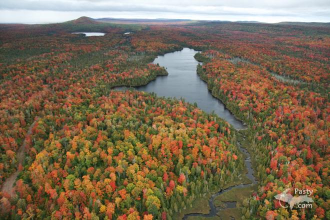
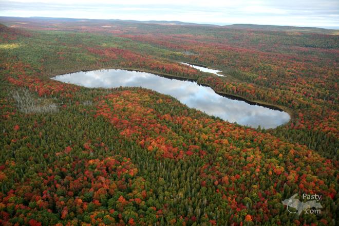
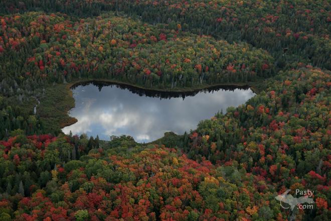
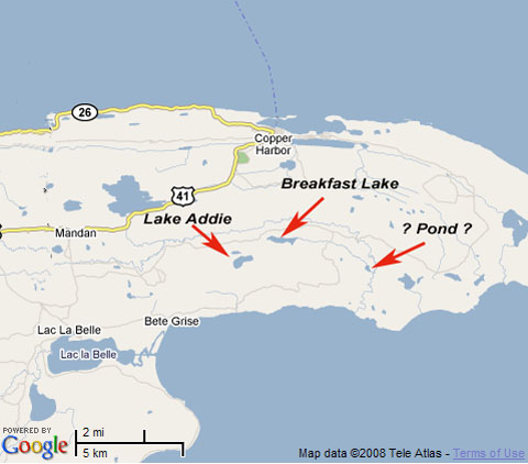
    Here's a list of messages posted in the past 24 hours
    See our guest photo gallery for more great views from the U.P.

    Add a Message


    A user/password combination is now required to post messages to Cam Notes. Registration is free. Click here to register or maintain your I.D.
    Username:  
    Password:

    Home | Pasty Cam | Contest | Order Now | Bridge Cam | Past-E-Mail | GP Hall of Fame | Making Pasties | Questions