Apr 25-08

Past-E-Mail: Cam Notes - 2008: April: Apr 25-08
Flying over Montreal    ...scroll down to share comments
Photos by E. Neil Harri
Rushing to the Big Lake    ...scroll down to share comments
Photos by E. Neil Harri
Raging and churning    ...scroll down to share comments
Photos by E. Neil Harri


By
Mary Drew at Pasty Central (Mdrew) on Friday, April 25, 2008 - 07:01 am:

If you've ever made your way to the mouth of the Montreal River on the Keweenaw Tip, you know how pretty the water flowing out into Lake Superior can be. But this time of year that beauty takes on a sense of urgency, as the river fills itself with the water left from the melting snow. Pasty Cam pilot E. Neil Harri gets up and over the spot where the Montreal empties herself into the Lake, to give us a unique perspective. It definitely looks like the surge of water entering the Big Lake is creating a current for quite a distance into the waters. The angle of the second photo shows what looks like a path underwater that's deeper than the lake bottom to the right of the flow. Like perhaps the force of that water rushing through is dredging out where the water pathway is flowing. Any science teachers tuned in to verify that's what we're seeing?


By Donna (Donna) on Friday, April 25, 2008 - 07:03 am:

AMAZING!!!


By Smfwlk (Trollperson) on Friday, April 25, 2008 - 07:11 am:

Great pictures!


By Brenda Leigh (Brownmoose) on Friday, April 25, 2008 - 07:33 am:

What spectacular shots Neil! A gorgeous spot indeed. Our hiking group enjoyed an outing there at the mouth of the Montreal. It was a windy day and the water at the mouth where the falls are was being blown up stream. It was a sight to see.
These photos allows one to see it from a unique perspective. THANKS.


By Justin Raddatz (Raddatz) on Friday, April 25, 2008 - 07:38 am:

Wow


By Alex "UP-Goldwinger" (Alex) on Friday, April 25, 2008 - 07:57 am:

Superior pics!


By E. Neil Harri (Ilmayksi) on Friday, April 25, 2008 - 08:00 am:

I think the warmer river water tends to float over the colder, denser lake water before it eventually mixes. It could also be the added air in water as it foams over the rapids on way to lake that lets it flow so far into Superior.Along with all that force but, hey, I'm no scientest.


By Marianne Y (Marianne) on Friday, April 25, 2008 - 08:01 am:

Those are wonderful pictures! Thank you, Neil Harri & Mary! There is some serious power in that water as it rushes into Mother Superior!


By JAD, Oscar, MI (Jandalq) on Friday, April 25, 2008 - 08:41 am:

Great photos. Neil, I wonder if the upper falls could some time be photoed. They must be spectacular this time of the year.

Ask and you shall receive...

Upper Falls
Thanks Neil!

By
dotti caldwell (Dotti) on Friday, April 25, 2008 - 09:17 am:

Really great shots - So interesting to see what's going on in mother nature from a different perspective! Loved em.


By Dunerat (Dunerat) on Friday, April 25, 2008 - 09:18 am:

Great photos, as always, Neil!

How do you get to the mouth of the Montreal? Do you drive the Mandan Road from Copper Harbor, or can you get there from the Bete Grise side? Do you park somewhere and hike in? I've always wanted to see it.


By kay Moore (Mskatie) on Friday, April 25, 2008 - 09:28 am:

What a wonderful view The Creater must have, hey?!!!!!!!


By Deb S. (Usedtobeayooper) on Friday, April 25, 2008 - 09:44 am:

Those are wonderful! Neil, your pictures just get better and better, if that's possible. Thanks!

Like Dunerat, I would like to know how to get there.


By Uncle Chuck @ Little Betsy (Unclechuck) on Friday, April 25, 2008 - 09:57 am:

Great Pic's Neil! Love to go boating out there. We get there with 4 wheel drives from both, out of Copper Harbor and from the Bete Grise side, great 4 wheeling country!


By D. Clark (Dcclark) on Friday, April 25, 2008 - 10:02 am:

Dunerat: my favorite way to get to the Montreal falls is like this. In Lac La Belle, follow the highway around towards Bete Grise. There will be a sign for "Smith Fisheries" on the left at a small dirt road. Follow that for a few miles -- but only in a Jeep or 4WD car! You'll come to the MNA's Bare Bluff nature sanctuary turnaround -- keep following the trail. Eventually you will come to a point where the road basically ends near the lake, with a little parking area. Park there, and hike in about another mile following the remaining trail.

It's a beautiful area, but the falls are rarely this amazing later in summer!


By Dunerat (Dunerat) on Friday, April 25, 2008 - 10:20 am:

D.Clark --

Thank you for the information. A couple of years ago I'm pretty sure I went in the raod to Smith Fisheries, but after a short while I came to some "no tresspassing" signs. I didn't know if they were legit or not, and but I didn't want to tresspass. There was another rough road that branched off to the north, then swung around to the east, and we followed that (4WD, for sure), but after a while it got a little too primitive for the amount of time we had that day.
Is the "Smith Fisheries" road private? Thanks for the help in advance.


By D. Clark (Dcclark) on Friday, April 25, 2008 - 10:28 am:

Dunerat --

According to this page, the trail is available for use to access the Bare Bluff sanctuary. Unfortunately, the official MNA page has gone away (they're updating their site), but I recall their description saying that "this road is marked private, but that is incorrect." So, you can take the road to the sanctuary, and then continue from there.

There are also occasional signs pointing towards the falls along the road, so I believe that it is OK to access. The road mostly goes through paper company land, so as usual, don't do anything destructive and you will probably be fine. :)


By doug 6540 (Cwo) on Friday, April 25, 2008 - 11:26 am:

Great photos...Brings back many wonderful memories of taking our small boat out to the mouth and sleeping on the beach in sleeping bags. We'd get up early and tie into many 8-10 lb steelhead trout most of which we released. Kept a few to prove we had been fishing instead of keeping BOSCH brewing co.in business at the Mosquito Bar..
GOD and ME, we luv the U.P.


By Alex "UP-Goldwinger" (Alex) on Friday, April 25, 2008 - 11:27 am:

Dunerat...D. Clark is correct. The road is open to the public even though there is a no trespassing sign. In case you have never been, the hike to Bare Bluff is in that same area and I highly recommend it. It is a medium intensity hike, but the view of Lake Superior is worth the effort.


By Richard L. Barclay (Notroll) on Friday, April 25, 2008 - 11:53 am:

Great photos! Could those be sand pockets reflecting the light in the water from the right side of the outflow as compared to clean swept rock to the left? If the lake level was lower at some point in the past the river could have run to the west or left and carved it deeper there? Could the river sand be deposited there by a clockwise current in the Keweenaw bay? Curious, where's our resident geologist or limnologist or whatever ?ologist is appropriate? We need help? (At least I'd like some!)


By Jerry Johnson (Jerryjohnson62) on Friday, April 25, 2008 - 12:10 pm:

Neil Great pictures


By Suzy Lofquist (Suzymn41) on Friday, April 25, 2008 - 12:26 pm:

Thank you for the great pics today and the info about getting to this pristine area. It's probably good that it's so hard to find so it doesn't get overrun. I must say I've tried several times and with the precise directions today perhaps it can become a reality!


By Brooke (Lovethekeweenaw) on Friday, April 25, 2008 - 01:03 pm:

Great shots and all the information on how to get there. My little car will not make it, must find 4wd.


By FRNash/PHX, AZ (Frnash) on Friday, April 25, 2008 - 01:24 pm:

"The road is open to the public even though there is a no trespassing sign."

Now that's a fine state of affairs!

If the road is open to the public, then why the "No Trespassing" signs?

Doesn't that encourage disrespect for all "No Trespassing" signs?


By D. Clark (Dcclark) on Friday, April 25, 2008 - 01:42 pm:

More than likely the sign was correct at some point. Then land changed hand and simply nobody has taken the sign down.


By Cindy Pihlaja Russell (Gone2long) on Friday, April 25, 2008 - 02:31 pm:

Limnology: The scientific study of the life and phenomena of fresh water, especially lakes and ponds. Kewl! Another new word today.


By Eugene Zuverink (Zube) on Friday, April 25, 2008 - 02:58 pm:

D Clark. The road ends near the lake. Why does it end "basically' near the lake?


By D. Clark (Dcclark) on Friday, April 25, 2008 - 03:05 pm:

Hi Eugene, what I meant was that it "basically ends" -- the road continues as a trail, not driveable. So, you have to park where the road "ends", which is near the lake, and continue on foot.


By E. Neil Harri (Ilmayksi) on Friday, April 25, 2008 - 03:24 pm:

The man with the correct access answers is workng out of town today. The river is on the state land aquisition on Keweenaw point. People used to be able to drive to it. There was a dangerous drop on the road where it ends now.
The road was bermed to prevent accidents on state land. You have to walk the last stretch in or go by boat. Either way, it is worth it.
I believe the Trespass sign was from the last owner of Smith fisheries who didn't want people crossing property.
It is an outstanding parcel of land for the state trust fund to buy to insure it stays in the public domain for future generations.If we are impressed, imagine what they will be saying about it in 100 years.


By Janie T. (Bobbysgirl) on Friday, April 25, 2008 - 04:17 pm:

These pictures are just outstanding! The different shades of blue water is beautiful. We are at the start of some serious flooding in eastern Iowa. Since 7 a.m. today alone we have recieved 5 in. of rain on top of the near 4 in. for the last 2 1/2 days. Farm fields won't be worked in for several weeks yet.


By Capt. Paul (Eclogite) on Friday, April 25, 2008 - 05:33 pm:

Your resident geologist was performing his civil duty by getting called to jury duty today; luckily I got out of it. It’s amazing what State employment will get you into/out of.......
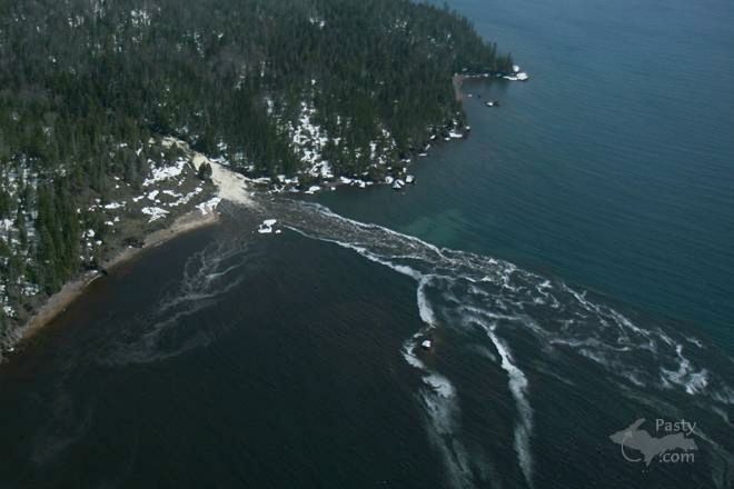
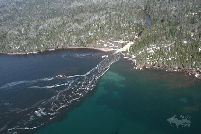
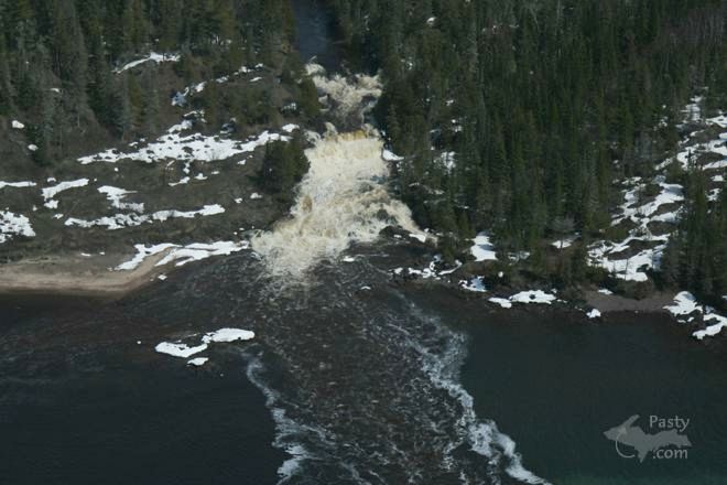
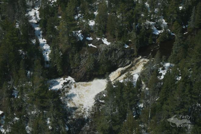
To the Montreal River! I will admit I’m no expert when it comes to river systems, but it would appear that the light coloured material under the foam in the second picture might be all the silt/sand that is dropping out of the current as the river slows into the Lake. Remember too, the river is much more powerful this time of year than at any other time of year, which would contribute to increased deposition. If you take a boat with a depth sounder over the mouth there is a small delta of sand and rock underwater from the river that has built up over time. However, it usually doesn’t stay in the same place as the winter ice likes to shift sand bars around.

Maybe I can convince my better half to come on later and post something even a little better??


By Walter P McNew (Waltermcnew) on Friday, April 25, 2008 - 05:43 pm:

beutiful ect.===i remain walter p.


By Keith in Kansas (Keithinks) on Friday, April 25, 2008 - 07:51 pm:

Great shots Neil!


Powered by:  
Join Today!
Each day the Pasty Cam has 2 areas to post messages: 
  • Cam Notes - comments related to today's picture and discussion
  • What'sUP - other topics, conversation and announcements
  • *** Please use the appropriate forum ***
    Here's a list of messages posted in the past 24 hours
    See our guest photo gallery for more great views from the U.P.

    Add a Message


    A user/password combination is now required to post messages to Cam Notes. Registration is free. Click here to register or maintain your I.D.
    Username:  
    Password:

    Home | Pasty Cam | Contest | Order Now | Bridge Cam | Past-E-Mail | GP Hall of Fame | Making Pasties | Questions