June 07-06

Past-E-Mail: Cam Notes - 2006: June: June 07-06
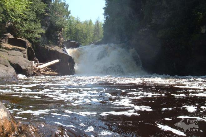
Sturgeon River Falls    ...scroll down to share comments
Photos by Grant Soehnel
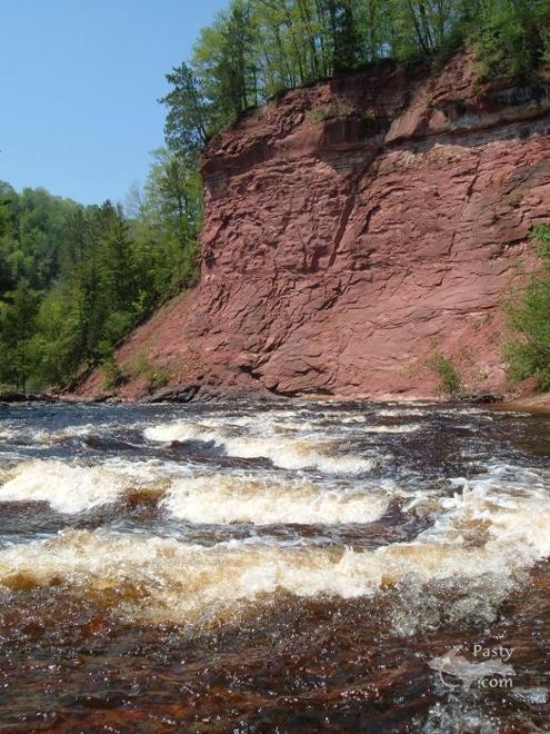
Sandstone wall    ...scroll down to share comments
Photos by Grant Soehnel


By
Mary Drew at Pasty Central (Mdrew) on Wednesday, June 7, 2006 - 07:05 am:

The Sturgeon River is located along the Baraga/Houghton County line between M-28 and M-38, just east of Pelkie. The falls pictured in the first shot sent in by Grant Soehnel is quite the geological setting, since the water flows over formations from volcanic rock outcrops. Just a short distance downriver from the falls you'll find these sandstone walls, shown in the second shot. They're nearly two stories high and seem to be sliced to form a narrow gorge. The gorges and canyons along this river are said to be up to 300 feet deep, which, according to Hunt's Guide to Michigan's UPPER PENINSULA, is the deepest valley in Michigan! Correct me if I'm wrong, Capt. Paul and feel free to add more details if you're so inclined! :->


By Deb S. (Usedtobeayooper) on Wednesday, June 7, 2006 - 07:10 am:

Oh Mary, those are so awesome. What a start to the day! Thank you Grant. There's nothing like standing next to some Falls (unless it's standing next to the lake). Anyway, these are absolutely breathtaking.


By Margaret, Amarillo TX (Margaret) on Wednesday, June 7, 2006 - 07:23 am:

Great pictures and it's sunny outside too.


By Marsha, Genesee/Aura (Marsha) on Wednesday, June 7, 2006 - 07:30 am:

Baraga County has the BEST falls!


By Eddyfitz (Eddyfitz) on Wednesday, June 7, 2006 - 08:00 am:

When I was a student at LAKE LINDEN-HUBBELL HIGH we would help Mr Graham with weeding his strawberry patch and he in return would take us on a "fishing trip" down on the Baraga Flats. As we fished the small streams we could hear the water rushing over the Sturgeon River Falls and they were always number one on our to do list to view that weekend.
Hope all is well in the Copper Country as we move into the summer season.


By Capt. Paul (Eclogite) on Wednesday, June 7, 2006 - 08:32 am:

Well, with that kind of an invitation........ ;-)

I would actually call the Sturgeon River there a gorge since it does have steep sides, so deepest gorge in Michigan yes. Deepest valley, well, I can think of several valleys that are deeper; back side of Brockway looking towards Lake Medora for example.

The sandstone wall in the second shot is our good friend the Jacobsville. The rocks in the first picture, believe it or not, were at one time also sandstone!! Early in the Precambrian (Huronian to be exact), a large shallow sea covered the Lake Superior region. During that time thick sediments (sands, silts, muds, pure lime, etc...) were deposited which were then metamorphosed into quartzites, slates, and marble. The rocks that make up the actual Sturgeon Falls are a muddy quartzite/slate mix, with a little iron formation thrown in.


By Debra J McCumber (Debrajean) on Wednesday, June 7, 2006 - 08:34 am:

WOW! These pictures are gorgeous!! Hey Nate, is this where you were going to take us when we were up there? If so, we'll have to make it a point to make it there next time.


By JanieT (Bobbysgirl) on Wednesday, June 7, 2006 - 09:02 am:

Awesome pics of undisturbed nature!


By WishingIWasInDaUP (Sur5er) on Wednesday, June 7, 2006 - 10:13 am:

Wow! Beautiful pics :) What I would give to be sitting there, sticking my feet in the cold water ;)


By Michael Du Long (Mikie) on Wednesday, June 7, 2006 - 10:41 am:

I know this is a stupid question but can you get close to where the pictures were taken with a car. Can't walk far any more, but would like to see this in person.


By dlp (Babyseal) on Wednesday, June 7, 2006 - 10:55 am:

Mikie, I know you can drive fairly close to the Sturgeon, but you do have to walk a little. It is a nice pathway. Downhill to get there and uphill back to the car. Sorry, but I do not recall exactly how far a walk it is. I wonder if one of those motorized scooters would work for ya?


By Ms. Katie (Mskatie) on Wednesday, June 7, 2006 - 10:56 am:

Wow Great scenes. Now I'll have to change my background in a few more days. Our world has so much magic big and small. We just have to stop and look once in a while. Sometime stop and take a close look at the bark on any tree.Or the shape of the petals on a flower. Magic


By Michael Du Long (Mikie) on Wednesday, June 7, 2006 - 11:22 am:

I used to laugh at my dad when he would complain about his hip hurting and how he couldn't walk long distances. I would say to him I will never get that bad that I can't walk any where I want to. Some people should learn to keep their mouths shut. Now I am being paid back for everytime I made fun of the old man. Boy genetics sure work, don't they?


By Budone (Budone) on Wednesday, June 7, 2006 - 11:37 am:

Wow, with the falls pictures, I am so ready to head north.

Now that I own my own business in Traverse City, my every six week visits to the UP are sadly missed.

However, July 4 week I will be up there campin and hikin and finding new falls to explore.

I can't wait, Neither can a buddy from TN who is visiting for the first time 'God's Country'!

Bill


By Steve Weis (Weezer) on Wednesday, June 7, 2006 - 11:48 am:

I can also think of some larger valleys, including some in the lower, an example being the Jordan River Valley - the view from Deadman's Hill is the best way to take in the size of that particular valley.


By Erica - Florida Keys (Erica) on Wednesday, June 7, 2006 - 12:15 pm:

From here(temp. is 85--heat index 95)those falls and the water look soooo refreshing! We are busy now trying to secure our home and property for the hurricane season. Hope this season is not a rerun of 2005. Anyway,first sign of a storm and we head UP!


By Dr. Nat in Texas (Drnat) on Wednesday, June 7, 2006 - 01:36 pm:

I wish I was there right now, sitting by the river. I think the hardest part of being a geology professor in east Texas is the fact there aren't any rocks to look at. Just swamp and urban sprawl.
Erica's post made me think of something I wrote in one of the books I'm writing. I was reflecting on fleeing Houston in the event of a hurricane. Then I thought, why wait for a hurricane? Any day is a good day to flee Houston. Especially if your destination is the U.P.


By Michael Du Long (Mikie) on Wednesday, June 7, 2006 - 01:50 pm:

Nat, Come on back to paradise, if not to UP try the lower there are places there that are almost as beautiful.


By Marsha, Genesee/Aura (Marsha) on Wednesday, June 7, 2006 - 02:37 pm:

Mikie: Click on the link to Hunt's in Mary's post and it'll give you all the info you need. Also talks about an area that is wheelchair accessible. I can't do much walking or climbing either. I'm going to have to make one last search for my waterfall book and if I can't find it, buy a new one. It had all my handwritten comments in it, too!


By Lynn White (Lynndeepoo) on Wednesday, June 7, 2006 - 02:56 pm:

Actually, this spot brings a lot of saddness to me today. These are the falls that an MTU geology student fell over and was killed July 29, 1981. There was a tree planted near the MTU geology building in Al's memory. Does anyone know if it is still there?


By Capt. Paul (Eclogite) on Wednesday, June 7, 2006 - 03:26 pm:

Trust me Mikie, if there was a way, ANY way, we could get back to the UP, we would in a second!!


By Dean Woodbeck (Dwoodbeck) on Wednesday, June 7, 2006 - 05:10 pm:

All you Pasty Cammers:
Don't forget to vote for your favorite photos. In recognition of Pasty Central's 10th anniversary, our annual Pasty Cam Calendar will include the best of the best photos -- and your votes will determine which photos we use.

Just send a link to your favorite(s) (no more than four, please) to 2007Calendar@pasty.com

Dean


By Grant Soehnel (Soehnelg) on Wednesday, June 7, 2006 - 05:24 pm:

For those of you wondering about access to this site here goes. The way I know is if you're heading from M38. About 7-8 miles west of Baraga is a dirt road heading south, and there will be a brown sign saying Sturgeon River Wilderness and/or Silver mountain. Heading west from Baraga you cross the Sturgeon on M38 first in a wide valley. Then about 2-3 miles further west you'll find the brown sign just as you drive over the top of a hill. It might say something about Pricket Dam Road there too. Head south on that road and it will come to a T after about 3 miles. Take a right. The road will wind around for about another 6 miles before crossing the sturgeon river. About another 2-3 miles and the trailhead parking is on the left. If you reach another T in the road you went too far by just about a half mile. From the trailhead it is about a 3/4 mile hike to the falls, and you have the option of taking a long switchback or if you keep walking along the rim past where the switchback starts the trail will head straight down the valley. It is a big descent either way, but the switchback should be managable for most people. If you get to the falls, I really encourage you to walk about 1/4 mile downstream to where the big sandstone cliff is in the second picture. There isn't much of a trail, but it's pretty easy walking along the river. If you noticed a trail branching off to the right just before you started hearing the waterfall, I believe that trail might take you to the sandstone cliff as well, but I just follow the river.

Grant


By Walter P McNew (Waltermcnew) on Wednesday, June 7, 2006 - 05:43 pm:

fantastic falls not very far from da alimi camp on the south laid road really great picts.


By eugenia r. thompson (Ert) on Wednesday, June 7, 2006 - 06:09 pm:

Can't wait to explore Hunt's Guide website. I didn't even know it existed. What fun that's going to be. Thanks, Mary.


By Michael Du Long (Mikie) on Thursday, June 8, 2006 - 01:07 am:

Grant, I love these pictures. I am going to try to visit them this year. If I take my time and rest along the way I should be able to make it. I am trying to talk my son into going UP with me and I know with him I can make the walk.


By Michael Du Long (Mikie) on Thursday, June 8, 2006 - 01:19 am:

My grandmother DuLong was born on the Sturgeon and would tell me about it when I was a kid. She lived in an area that was mostly French Canadian. She said the fishing was great when she was little so they are a lot of fish and had a lot of game to eat. Her favorite treat was peanut butter and strawberry jam on homemade bread. Also loved pancakes with a lot of butter and maple syrup. Remember when the maple syrup came in those little tin cabins? I would save them and have a little town of the cabins, and also small pieces of wood that were cars or whatever my mind wanted them to be.


By Bob Cunningham (Cunningham51) on Thursday, June 8, 2006 - 12:40 pm:

This is still my favorite spot to backback and camp. It is pretty much unchanged from when I first went there in the early 70's. A couple of times we waded accross the river in early fall when the water was low and camped on the emerged beach right accross from the sandstone cliffs. The river is beautiful to follow as it winds and drops with many other smaller rapids. Back in the 70's I had heard that a coed from NMU had also fallen from the cliff and perished. The North Country Trail now comes through this area.

BTW, Welcome home Dean


By Norm Bishop (Riverdog) on Friday, June 9, 2006 - 10:16 am:

Wonderful location. It has been years since I
was on the sturgeon.


By Capt. Paul (Eclogite) on Friday, June 9, 2006 - 10:57 am:

It would seem to me that the river route would be a much better way, especially for a geologist looking for the quartzite/sandstone contact. A great area to visit none the less.......


Powered by:  
Join Today!
Each day the Pasty Cam has 2 areas to post messages: 
  • Cam Notes - comments related to today's picture and discussion
  • What'sUP - other topics, conversation and announcements
  • *** Please use the appropriate forum ***
    Here's a list of messages posted in the past 24 hours
    See our guest photo gallery for more great views from the U.P.

    Add a Message


    A user/password combination is now required to post messages to Cam Notes. Registration is free. Click here to register or maintain your I.D.
    Username:  
    Password:

    Home | Pasty Cam | Contest | Order Now | Bridge Cam | Past-E-Mail | GP Hall of Fame | Making Pasties | Questions