Nov 24-02

Past-E-Mail: Cam Notes - 2002: November: Nov 24-02
The way we were    ...scroll down to share comments
Photo courtesy of Paul Meier

By
Paul Meier, Illinois on Sunday, November 24, 2002 - 09:18 am:

Here's a B&W of tailings being discharged into Lake Superior from the Champion Mill at Freda in 1963. I made the photo with an Argus C-3, my first "real" camera. This might make some of the present day environmentalists cringe, but it was the way things were.

Best wishes for the coming Holidays,

Paul Meier


By Charlie H, on the road in MN on Sunday, November 24, 2002 - 09:19 am:

This week we will be thinking about some of the things for which we are thankful. Lake Superior is one gift which comes to mind. Thanks to Paul M. for reminding us historically of the constant need to keep it clean.

Edie and I are still in Minnesota at the Women's Hockey Tournament where the MTU Huskies are competing. Last night they defeated the Madison Lightning 4-0, after loosing a close one to Fox Valley earlier in the day. This afternoon they have a shot at the consolation championship, we'll let you know how they fare.

UPDATE: The MTU Women Huskies defeated a tough Milwaukee Team 2-1 in overtime for the trophy.


By JoeBob, Dallas Texas on Sunday, November 24, 2002 - 09:42 am:

Great picture of the mill, I thought it stopped running much earlier.

Question: does anyone know where the tailings at the Houghton breakers/North Entry (old Stantion Township park) came from a few miles to the north? I can't find a mill around the breakers area in historical records.

A local history professor speculated that maybe they shipped the tailings from the Quincy or the Isle Royale mines to the Houghton breakers/North Entry to keep the Portage Lake channel clear for shipping. He also said that maybe the Freda sands drifted north to the North entry area (I doubt that, we are talking a few miles to the north).


By Jim California on Sunday, November 24, 2002 - 09:51 am:

I believe the sands have shifted North as there is a current which runs across Lake Superior against the Keweenaw Peninsula. The sands at Gay have also shifted south from a similar current.Out here in California massive amounts of sand can shift many miles in a few short stormy years. Santa Barbra harbor is a good example.


By MTU geo-grad, now at GSO-URI on Sunday, November 24, 2002 - 10:42 am:

What you're talking about is a fundamental beach process called "longshore drift". This website has some good pictures that might help explain: http://www.gvsu.edu/videticp/longshore.htm


By Sue,Lake Linden,MI on Sunday, November 24, 2002 - 11:55 am:

3 to 6 inches today. 8 to 12 tonight. Time to get the snow blower to the front of the garage today.


By Daryl Laitila (Daryl) on Sunday, November 24, 2002 - 12:29 pm:

You may purchase the new Pasty Cam 2003 calendar along with other gift ideas here, Pasty Softwear. You may also include a calendar with your pasty order. This year's calendar is full size, 11" x 8.5", full color and printed on glossy paper.
Some of this year's photos


By Dale from Florida on Sunday, November 24, 2002 - 02:39 pm:

In regard to the man on the bike carrying the deer. I think you must be right Sarah, the deer must have been shot earlier, cause hes not wearing the right colors. Come to think of it, wearing brown, sitting on a bike with a deer on your shoulders is a good way to get shot anyway, if the weight of the deer don't get ya!


By finkin - MI on Sunday, November 24, 2002 - 09:16 pm:

The deer cyclist is becoming a legend in his own time!

Re: Sue - Looking forward to some Keweenaw snow pictures.


By Alice, Ventura, CA on Sunday, November 24, 2002 - 09:22 pm:

Hey Jim, California-
Are you in Santa Barbara? I lived there for quite a few years. That channel was always closing because of the sand drift.


By Alex Tiensivu, Georgia on Sunday, November 24, 2002 - 09:22 pm:

Jim, California said:

The sands at Gay have also shifted south from a similar current.

Alex says:

I hope not too much! I wonder, after all these years, what the shoreline in Gay looks like now! I used to swim there and remember it well, but it's SO long ago!

My Grandmother, Hilda Tiensivu, used to work something in that location having to do with coal. I can't remember what it was... I think a coal dock, or something like that? I'm speaking of an area you can walk to from The Gay Bar. (My dad was born in the house across the street from The Gay Bar!)

Somehow, I just have this image in my mind that when I bring my family up to the U.P., nothing will have changed. I hope I'm right!

It's just the ONE place one figures will never change! :)

Alex


By Ed Chaput on Sunday, November 24, 2002 - 09:57 pm:

http://www.skypixs.com/KEWEENAW_WATERWAY/Dscf3937.jpg

This is the Keweenaw waterway where it enters Lake Superior enroute to Isle Royal..On the right would be Mcleans State Park and on the left would be stamp sand from unidentified stamp mill..By my maps it looks like Redridge and Freda are about 8 to 10 miles to the west. I do show a little site of EDGEMERE that was the stamp mill for the ADVENTURE CONSOLIDATED MINING COMPANY and i think it may have been in that area where the sands originated.


By Fran,Ga. on Sunday, November 24, 2002 - 10:21 pm:

Alex, how long has it been since you were home?I was out there this summer. It looks pretty much the same to me.We found the spot where the pipe or tunnel goes under ground. It is to the left of the path. It was so beautiful! We enjoyed just listening to the waves lapping and looking at the scenery. Heaven on earth!


By Gary, CO on Sunday, November 24, 2002 - 11:02 pm:

The mill at Edgemere only operated for a few short years in the early 1900's, so most of the stampsand must have come from the mills at Freda, Beacon Hill, and Redridge. At times there was a continuous "beach" from Freda to Redridge and then on to the northeast and at other times, the sands would drift and it would be gone.


By Mike Mehrman, MI on Monday, November 25, 2002 - 08:21 am:

I hope the snow forecast isn't to severe, I feel sorry for my poor aging aunt whom lives in Bootjack.


By Phyllis from WA on Tuesday, November 26, 2002 - 02:49 am:

The Freda Mill closed on Saturday, November 4, l967. It was a sad time for many. My dad worked there and he still talks about that place. I remember touring the mill with the kids from Redridge School.


By Paul in Illinois on Tuesday, November 26, 2002 - 10:00 pm:

I, too, have been in Minnesota. Thanks for the comments. As to the sands appearing at the North Entry, Champion, Trimountain, Atlantic, Baltic, and Adventure all had mills to the west. Superior being what she is could well have moved some sand there. Quincy had to barge some sands from its old mill at Hancock out to the big lake, they were starting to encroach on the shipping channel.
Champion didn't dump all its stamp sand into the lake. Because of the very steep dip of the Baltic Lode, they actually hauled quite a bit back to the mine and dumped it back in. They used it to fill in stopes so the miners would have a place to stand while working.


By Steve, MI on Sunday, December 8, 2002 - 09:54 pm:

We live on Superior, about two miles south of the North Entry. The stamp sand from the mills mentioned by Paul are still moving around a lot. Our beach varies from a sheer cliff of sand when the ice melts, to a long slope after the August winds.

Some of the lifelong residents around here (I am a transplant) remember looking out from the schoolhouse at Redridge and seeing sand WAY out into the lake. One neighbor tells me the water used to be very red. It is still quite brown when agitated, but I don't know how much is from the stamp sand.


By Bob Brown, Alabama on Sunday, December 8, 2002 - 11:34 pm:

One of the old stories was how the Freda mill avoided the dreaded wooden "launders" which were large wooden troughs that "tailings" flowed through on their way to a final resting place. The Isle Royale Sands (grey) and the red sands from the many mills on the north side of Portage lake and some on Torch Lakewere handled this way. Most of the mills had to keep repairing and extending the launders while the Freda mill let the lake take away the tailing. Later, when better processing methods were developed, the Quincy and C&H used dredges to reclaim the tailings and modern mills to reclaim the copper. Reclamation kept several of the companies in business for many years, while the Copper Range tailings from Freda Mill, and the copper they contained, were long gone. My grandfather, John Berry, lived in West Houghton and worked at the Copper Range Smelter on the Canal Road and used to tell many of these stories.


By mike in zeeland on Tuesday, December 10, 2002 - 11:55 pm:

Can anyone tell me why the mines closed down? My dad told me it was because of the unions trying to come in in the late 50's. The companys said they would shut down if they voted the unions in and they did. So what's the story? I've heard different things so any info would be helpful.


By ed on Friday, December 13, 2002 - 11:34 pm:

Mike, the companies were union and my father was a minor official in the Mine Workers & Smelters Union in the 50's & 60's. The C & H was purchased by Universal Oil of Chicago at about that time and they were bean counters and the little operation in Calumet area meant nothing to them on thier bottom line. It is my understanding that the strike started in 1967 and lasted one year and when they finally had a vote to continue the strike the company feared it would cost too much to re-open the mines and then shut them down. The copper is still down there but too expensive to remove now days.


By Carolyn, Maryland on Tuesday, February 18, 2003 - 11:30 pm:

Regarding the sands that used to extend beyond the
Freda cliffs. My grandmother related that there did
used to be huge stamp-sand beaches below the Freda
cliffs until a dredge came and hauled it away.

I used to have a picture of the dredge in action. I still
have pictures of the expanses of stamp sand at the
base of the Freda cliffs. It is hard to believe that the
residents climbed down those steep cliffs to get to a
beach.


By Herb_NW.Wis on Tuesday, October 21, 2003 - 01:17 pm:

I just found this site and it looks good. Are
people still posting?

I live in NW Wisconsin and love going up the UP
to Keweenaw Point to look for copper. The
spooky sense of history hanging over the place
is incredibly vivid and tangible.

I love it...

Didn't get up there this year so I ordered a
couple of new books about the copper mines.

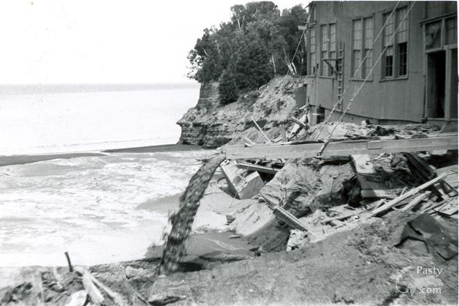
I've camped out on the Freda stampsands. Way
to the end (west?) where they pinch out at a low
sandstone cliff. That night there was a big
electrical storm and my tent collapsed, but I
couodn't get out or the "green biters" (flies)
would eat me alive! Had my motorcycle out
there. Took a bath in the lake but the water was
COLD. Remember passing the old Redridge
steel dam. I think that was the last time I was out
there.....


Powered by:  
Join Today!
Messages can no longer be posted to these older discussion pages, but you are welcome to join the conversation on Today's Pasty Cam

Here's a list of messages posted in the past 24 hours

See our guest photo gallery for more great views from the U.P.

While in the Copper Country be sure to visit
On US-41 north of Calumet
on US-41 in Kearsarge, a mile north of Calumet.
(The home of Pasty Central)

Home | Pasty Cam | Contest | Order Now | Bridge Cam | Pasty.NET | GP Hall of Fame | Making Pasties | Questions