Nov 22-02

Past-E-Mail: Cam Notes - 2002: November: Nov 22-02
Getting UP in the U.P.    ...scroll down to share comments
Photos by Jonathan Hopper
Closer look    ...scroll down to share comments
Photos by Jonathan Hopper

By S. Parks Cromartie, California on Friday, November 22, 2002 - 01:56 pm:

My brother (from Marquette) send me the link to the "deer on the bike" photo from November 20 (which was hilarious). From there, I started looking at your site and the photographs are incredible. Absolutely made me home sick!! God Bless the U.P.!


By Shelly, Las Vegas on Friday, November 22, 2002 - 05:49 pm:

This Finlander has been gone from dem dare Northwoods for twenty years. This photo made me so homesick. Thank goodness for disposable cameras and quick thinking! Just awesome! Thanks from Las Vegas.


By Charlie H., on the road again on Saturday, November 23, 2002 - 01:03 am:

Our deer hauling Yooper on Wednesday's shot was a hard act to follow. Friday's view of the highest point in Michigan will hopefully elevate the discussion to the next level. But I must say, I'm still laughing.

Edie and I are in Blaine, Minnesota, cheering on the MTU Women's Hockey Team at the tournament this weekend. Go Huskies!


By JAC, CO on Saturday, November 23, 2002 - 06:30 am:

Does anyone know what the elevation is at Mt Arvon?


By Kevin E. Musser on Saturday, November 23, 2002 - 06:44 am:

Mt. Arvon is 1,979 feet above sea level.


By jad, Oskar on Saturday, November 23, 2002 - 07:02 am:

Mt. Arvon = 1,979 ft. Interestingly: the Copper Country Vacationist League Pleasure Map pinpoints Mt. Arvon as the highest point in Michigan but gives no elevation. The Lake Superior Travel Guide put out by Lake Superior Magazine shows Mt. Curwood but not Mt. Arvon. Maps of Baraga County (but not Geol.Survey maps) show the Arvon Slate quarries but not the "mountain." Tsk on the mapmakers.


By think about it/michigan on Saturday, November 23, 2002 - 07:45 am:

I didn't think that the photo of the deer was funny at all. Why would you all laugh at the sight of a dead animal? Shouldn't there be a tribute to the animal that is giving his life so that you can have meat to eat? In the past, didn't the Indians say a prayer for the soul of the animal they killed?


By Kevin E. Musser on Saturday, November 23, 2002 - 07:56 am:

Mt. Curwood is 1,978 feet above sea level, close but no cigar.


By Deer Hunter on Saturday, November 23, 2002 - 08:19 am:

Praise the Lord, Pass the Potatoes !


By Marcia, Seattle WA on Saturday, November 23, 2002 - 08:28 am:

I also discovered this site through the deer photo. Though I am a troll from the Lower Penninsula, it still made me say "how Michigan". After looking at some of the other photos, I said "how I miss Michigan".


By Mary on Saturday, November 23, 2002 - 09:06 am:

Come on folks, Charlie wanted these Mt. Arvon pictures to "elevate the discussion to the next level."

Everyone has an opinion, as they should, let's not make this another argument over who thinks what's right and what's wrong.....let's just be Thankful that we have the right to have an opinion! :) Thanks!


By bob somewhere in the u.p. on Saturday, November 23, 2002 - 09:07 am:

Hey, I know that guy on the bike. I saw him making crop circles in my dads yard, last year. When we confronted him he disappeared. About 2 weeks ago we saw him making snow angels on the main drag in Ironwood. When i grow up I want to be just like him.


By Jeff,VA. a non hunter on Saturday, November 23, 2002 - 09:14 am:

I don't think anyone is laughing at the dead dear.To me it is showing how determined the hunter is to get it home so it doesn't rot in the woods,and feed someone who would be greatful for it.A very enterprizing young man.


By Abbey, North UP on Saturday, November 23, 2002 - 09:15 am:

How do I get to the summit of Mt Arvon?


By A Yooper in Wyoming on Saturday, November 23, 2002 - 09:17 am:

To think about it,as far as I've seen most hunters have more respect for the animals they hunt then humans have for each other.The way nature deals with over population is not as humane as a hunters bullet or arrow


By Uncle Bud/old Mohawk on Saturday, November 23, 2002 - 09:27 am:

What is that hovering just at the tree tops above the sign?
Humm looks like their back again.
Time for someone to take a wild ride??
Circle circle circle, I'm going round and round again. eh eh.


By Alex Tiensivu, Drooling in Georgia on Saturday, November 23, 2002 - 11:41 am:

I have officially determined that the U.P. is a world of its own. I look at these pictures and drool. There is simply no other place like it on Earth, and we ARE still looking to move up there.

I can't thank Charlie enough for this site.

Alex


By Katherine D. in G.R. on Saturday, November 23, 2002 - 11:53 am:

Dittos, Jeff and A Yooper,well said.


By Mike Mehrman on Saturday, November 23, 2002 - 12:29 pm:

Is Mt. Arvon located around the Huron Mountains??


By Mike Mehrman on Saturday, November 23, 2002 - 12:33 pm:

Looks like a bigfoot at the left of da photo of Mt Arvon.


By Lori A, wanna be home in MQT on Saturday, November 23, 2002 - 12:34 pm:

Charlie H...I'm in Blaine, Minnesota too! Do you suppose it's got a yooper magnet?


By Lyn R. on Saturday, November 23, 2002 - 01:50 pm:

Abbey,
I can send you directions by e-mail or fax.
The directions I have are my own and like some will not get you lost on all the logging trails. E-mail me if you still need them.


By Lowell MO on Saturday, November 23, 2002 - 03:10 pm:

You have to give the guy on the bike credit for at least getting his deer home. In the old days before all the motorized vehicles the hunters carried them home on their back.
Nice picture again. have always wondered where the highest point in the U.P. is.
Always enjoy all the discussion on various things.


By Lowell Mo on Saturday, November 23, 2002 - 03:17 pm:

For anyone who is interested I have the web site for the Ogden Newspapers which own the papers in 4 of the major towns in the U.P. Will gladly send you the web site just e-mail me at beaver@socket.net
The papers are from Marquette, Escanaba, Houghton,and Iron Mountain.


By Sue on Saturday, November 23, 2002 - 03:50 pm:

Where is Mt. Arvon? My father-in-law has always said that Calumet,Mi was the highest point in Michigan. Guess he is wrong. Anyone hear that one?


By Jim Mich UP on Saturday, November 23, 2002 - 04:34 pm:

Mt Arvon is Michigan's highpoint for now....officially 11" higher than Mt Curwood, which used to be the highpoint. From the 1950s to the 1970s, the survey maps indicated Mt Curwood was the Michigan highpoint, with an elevation a few feet higher than the now-reported 1978' for Curwood and 1979' for Arvon.
Interestingly, up into the 1950s, Government Peak (over in the Porcupine Mtns) was Michigan's designated highspot...at about 2023' above sea level. The situation was resurveyed and Curwood came out on top, only to be resurveyed again with Arvon now the state highspot. Wonder when another survey will move the highpoint again....perhaps Michigan is a unique state with its moving highspot!Jim


By AJR--ELMHURST,IL on Saturday, November 23, 2002 - 05:55 pm:

I was up there about 4 years ago on my snowmobile As you can see there is a mailbox on the back side of the sign post. A log book and pencil are available for you to sign in. I think it is provided by the local boy scout troop


By FRNash/PHX, AZ on Saturday, November 23, 2002 - 06:32 pm:

Mike Mehrman:
Is Mt. Arvon located around the Huron Mountains??
Yes, both Mt. Arvon & Mt. Curwood are among the Huron Mountains.

Western Huron Mountains

By
FRNash/PHX, AZ on Saturday, November 23, 2002 - 07:14 pm:

Abbey, North UP and any other interested parties,
As you can see from the above map, roads in the Huron mountains are a "maze of twisty passages, all different". So if you really don't want to "get lost on all the logging trails" (many of which aren't even shown on the map) maybe you really should take Lyn R. up on the offer of directions!


By Catherine--Holland, MI on Saturday, November 23, 2002 - 10:49 pm:

Is it within HMC borders? Will we all be chased off big big guys in SUVs?


By Lisa, Ypsilanti, MI on Sunday, November 24, 2002 - 04:29 pm:

bob somewhere, you crack me up.


By bob somewhere in da up on Sunday, November 24, 2002 - 05:01 pm:

are those mountains on that map really square like it shows them, and is there a big red fence around them, if so I won't have any trouble finding them. Thank you for the detailed map.


By Jim UP on Sunday, November 24, 2002 - 05:07 pm:

More High Point info.....Mt Arvon is easy to find; someone has conveniently posted the route with blue diamond signs all the way from the Swedish Luth Church corner on the Skanee Road )blacktop). Just follow the Roland Lake Road south. As you swing around the west end of Roland Lake, you really enter the bush...and the roads get progressively worse....but not THAT bad, as even a Yugo can make it. Just keep following the blue diamond "Arvon" signs. It's about 4 or 5 miles southwards from Roland Lake that you are directed to turn onto the Mt Arvon access road...after c. a mile of this, you walk the last third of a mile to the top. Enjoy the nonview!
As for Mt Curwood (complete with yellow birdhouse style log book holder, dating back to when THIS was Michigan's highpoint)....the trek there is very doable, but likewise very hard to explain (the oft' mentioned maze of poor roads and the lack of any credible landmarks, etc). Best bet is to have someone locally escort you there the first time.
To answer an earlier question: NO, neither is within Huron Mtn Club property. Only the flies and mosquitoes might chase you away!


By Catherine--Holland, MI on Tuesday, November 26, 2002 - 08:29 pm:

Blue diamond signs in the UP generally indicate you are on the North Country Trail, which will eventually continuously run from (I think) Maine to the WA peninsula.

I enjoy hitting small bits of it here and there in Ont. county whenever I go up north.


By Yoopergearle, MI on Wednesday, November 27, 2002 - 02:47 pm:

a little North Country Trail (NCT) info... not certain if these blue diamonds are in fact marking the NCT, but is very possible. The NCT will someday stretch more than 4,000 miles. When complete, will be the longest hiking trail in the United States. The trail runs from New York to North Dakota. Of the seven states that the trail passes,Michigan contains the longest percentage of trail. The UP contains close to 500 miles of NCT :) I sure hope this really is part of it - looking forward to exploring there!


By Wish I was a yooper, MI on Thursday, November 28, 2002 - 09:40 am:

I can't wait to get up there.


By Lisa, Ypsilanti, MI on Friday, November 29, 2002 - 04:26 am:

LOL again at bob.

Yeah, I am easily amused. ;-)


By Christian Rammazzoti on Wednesday, January 29, 2003 - 02:35 am:

AAAAAA....read your e-mail dearest...Cristi Popescu din indepartata Romanie!


By Jon Eastport, Mi on Saturday, July 26, 2003 - 09:01 pm:

Does anyone know what the highpoint for the lower peninsula of Michigan is?


By Ron, Reed City, MI on Monday, September 15, 2003 - 06:31 pm:

Does anyone know ehre the highest point in the lower is? It is around Cadillac somewhere, but have not been able to locate it.


By bonnie, IL on Tuesday, October 14, 2003 - 01:36 pm:

Does anyone know the elev of Mt Houghton? I was up there this weekend and saw a survey marker but no elev was on it.
Thanks


By fy on Tuesday, October 14, 2003 - 05:45 pm:

Mount Houghton 1466
Mount Bohemia 1465
Gratiot Mountain 1490


By fy on Tuesday, October 14, 2003 - 05:46 pm:

Briar Hill 1706 Wexford, LP


Powered by:  
Join Today!
Messages can no longer be posted to these older discussion pages, but you are welcome to join the conversation on Today's Pasty Cam

Here's a list of messages posted in the past 24 hours

See our guest 
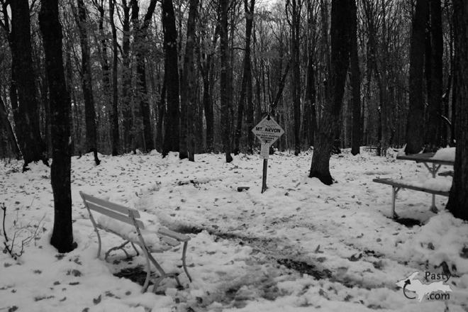
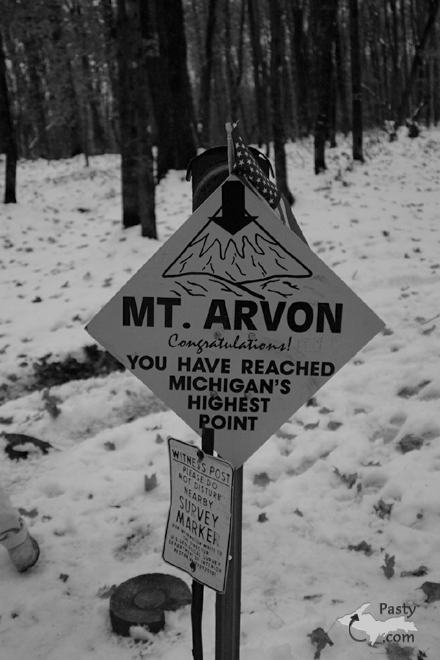
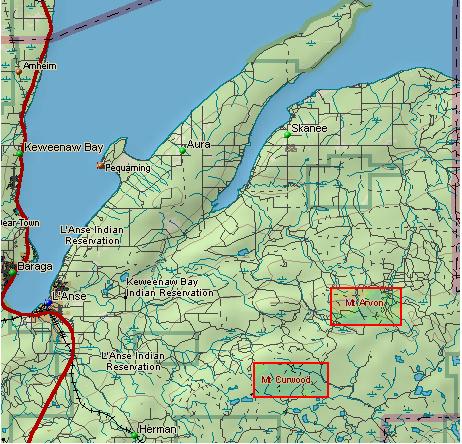
photo gallery for more great views from the U.P.

While in the Copper Country be sure to visit
On US-41 north of Calumet
on US-41 in Kearsarge, a mile north of Calumet.
(The home of Pasty Central)

Home | Pasty Cam | Contest | Order Now | Bridge Cam | Pasty.NET | GP Hall of Fame | Making Pasties | Questions