Sep 01-01

Past-E-Mail: Cam Notes - 2001: September: Sep 01-01
More SkyPix Aerials    ...scroll down to share comments
photo by Rick Anderson

By Jerry J, NH on Saturday, September 1, 2001 - 11:20 pm:

Is the town in the upper right hand corner of the picture Calumet?


By Mark on Sunday, September 2, 2001 - 12:46 am:

is this the new treatment plant heading south on 203 from Calumet?? Looks like Tamarack Location in the background.


By Toivo Keskimakillainen on Sunday, September 2, 2001 - 06:47 pm:

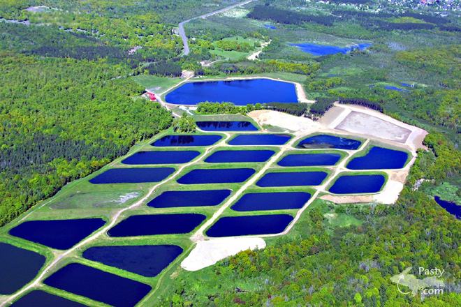
Sure does look like the Calumet area sewage ponds. From the way M 203 curves before the cemetary, past Lakeview Cemetary, to the way it curves again before the road to Bucky's. Backs when I was growing up in Calumet, the wetlands in the upper right corner were always marshy. But, one question. Are these wetlands affected every time I hear about a "Discharge" from the plant ? Like, when the area gets heavy rains ?? Maybee that's a good question for Keweenaw Issues.


By Charlie at Pasty Central on Tuesday, September 4, 2001 - 05:53 pm:

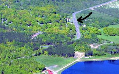
I just had to drive out to see this for myself. If you zoom in on the curve, you can actually see the entrance to Lakeview Cemetery. Look even more closely and you might see some of the monuments.

close-up
Personally, I had no idea such a large drainage area was located at that spot. Thanks, Rick, for enlightening us with your "eye-in-the-sky".

Powered by:  
Join Today!
Messages can no longer be posted to these older discussion pages, but you are welcome to join the conversation on Today's Pasty Cam

Here's a list of messages posted in the past 24 hours

See our guest photo gallery for more great views from the U.P.

While in the Copper Country be sure to visit
On US-41 north of Calumet
on US-41 in Kearsarge, a mile north of Calumet.
(The home of Pasty Central)

Home | Pasty Cam | Contest | Order Now | Bridge Cam | Pasty.NET | GP Hall of Fame | Making Pasties | Questions