Jun 23-03

Past-E-Mail: Cam Notes - 2003: Jun: Jun 23-03
View from Mt. Baldy    ...scroll down to share comments
Photo by Mary Drew
View from even higher (Skypixs)    ...scroll down to share comments
Photo by Rick Anderson

By
Mary Drew, Lake Linden on Monday, June 23, 2003 - 07:29 am:

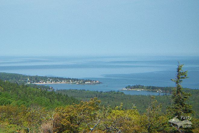
Another shot from a mini-vacation in the Harbor areas. One of the days was a perfect hiking day.... so up Mt. Baldy (Lookout) I trekked. A good hike, I've been told it's about 3.5 miles one way. Of course it was uphill both ways!!!! No, really it was a nice hike. The bugs stayed away, thanks to the Deet I was wearing and the view from up the top was fantastic. Spirit renewing for me anyway!


By Charlie at Pasty Central on Monday, June 23, 2003 - 07:31 am:

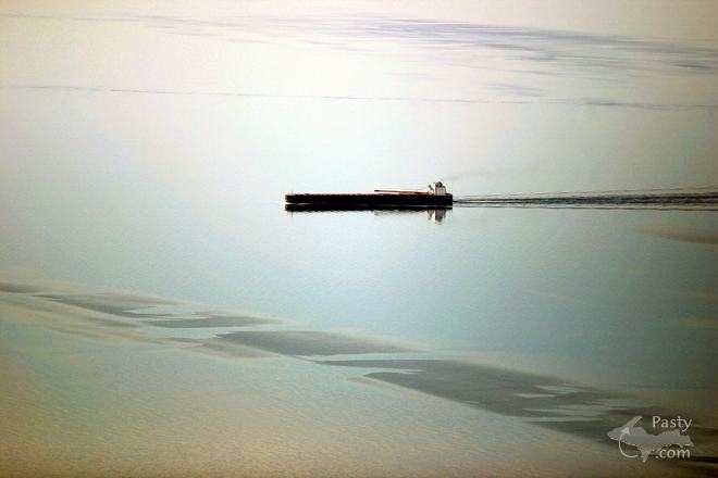
Great shot, Mary. Also, this week we are being treated to some lofty scenes around the Keweenaw Peninsula, thanks to the aerial lens of Rick Anderson. Love the way the wind plays across the water in the today's second shot. see skypixs.com for more.

By the way, you can see some other shots which Mary uploaded along with the Eagle Harbor scene... Pasty Central announces a brand new feature for guest Pasty Camists: their own personal Pasty Cam Gallery. Anyone desiring to upload pictures for possible use as the photo of the day may have their own webspace, which is also enabled with upload capability, with dynamic resizing and discussion features. Just email me if you have some shots you would like to upload and we'll send you a username and password.

To see more shots from Mary Drew, click here.


By Julie B. Holland The Netherlands on Monday, June 23, 2003 - 10:05 am:

Beautiful ......... where does the water end and
the sky start.... Julie B.....


By froggy on Monday, June 23, 2003 - 10:06 am:

The size and beauty of Superior still impresses me every time I see it, especialy when I see it from the mountain. Puts it in a perspective you dont get from the shoreline.


By yooperspud, coeur d alene, id on Monday, June 23, 2003 - 10:59 am:

where was the ore frieghter located at and how far offshore was it, and i want to know if those are sand bars in the picture, because they're really close to the ship


By Scott, Grand Rapids, MI on Monday, June 23, 2003 - 11:02 am:

I believe the horizon is about 2.5 cm down from the top of the picture, although with the diffused sunlight it's difficult to see. Also, based on the profile, I would venture a guess that the ship is the Paul R. Tregurtha, the biggest ore freighter on the Great Lakes at 1,013 feet (311.7 meters). Great picture that makes you realize just how vast and "ocean-like" Lake Superior really is.


By UP SLIM on Monday, June 23, 2003 - 12:18 pm:

Dont think those are sandbars. If they are, that captain has just bought the farm, as it takes quite a distance to stop or turn one of those big guys I am told. I think he'd be lookin for new employment if he grounded a loaded 1,000 footer.


By Martha L., Mishawaka, IN on Monday, June 23, 2003 - 01:03 pm:

The area that looks like it could be a sand bar is still deep water. I have seen this phenomenon on Lake Superior many times and also in Copper Harbor, where I grew up. I think it is probably caused by the wind and/or currents in the water, but I'm no expert.


By Cousin Jack on Monday, June 23, 2003 - 01:26 pm:

Ahh, one of my favorite spots. Great shot, Mary!
Here's how it looked from nearly the identical location after a hike I took up there last May 19th:


By Troll in E.H. on Monday, June 23, 2003 - 01:29 pm:

If you look REAL close you can see my home about 1.125 inches to the left of the lighthouse.


By MjN03, Arizona on Monday, June 23, 2003 - 02:13 pm:

Well I am back from my vaca in the U.P. I forgot just how beautiful it is and how much I miss it there. I will get some of the many pictures I have to Charlie and hopefully see some of them on the cam.

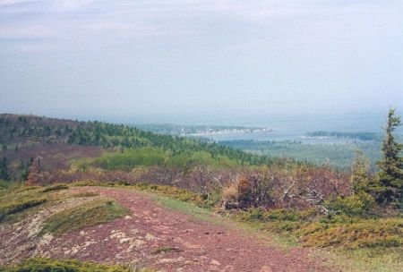
Here is a shot I took last Tuesday from Brockway. the fog settled over the harbor as the front moved in off of the lake.

http://members.cox.net/mjn03/temp/fogharbor.jpg


By Fran,Ga on Monday, June 23, 2003 - 02:57 pm:

MjNO3,Arizona,
A very pretty shot! Thanks


By bt,tc on Monday, June 23, 2003 - 03:28 pm:

Never been to Mt. Baldy...but it looks awesome. Hopefully someday I'll be able to make the trek. George from EH has mentioned it many times on his page. Thanks for the great pic....wish I was there. :-)


By Connie, Ft. Belvoir VA on Monday, June 23, 2003 - 03:54 pm:

Gorgeous pictures! Can you tell me how to get to Mt. Baldy? My uncle took me about 10 years ago and I can't remember.
Thanks.


By Troll in E.H. on Monday, June 23, 2003 - 04:14 pm:

CONNIE....Take the first 2 track on the left as you're leaving E.H.via the Cut Off Rd.Follow the trail up the hill and keep going.Cross the creek(feels kind of nice on the feet) and continue uphill. Kind of hard to get lost unless you're prone to wandering through the bush.Follow the creek down stream a ways and treat your eyes to some fanastic rock cliffs,cascades and waterfalls.Good luck!


By Wonderin' on Monday, June 23, 2003 - 05:18 pm:

Do you drive up the 2-track or park out on the cut-off road?


By misplaced yooper on Monday, June 23, 2003 - 09:44 pm:

Heard there was a big fire in Calumet last night...geez at the rate its going there aren't going to be any historic buildings left! I guess you could see the flames shooting up into the sky all the way in Mohawk! Does anyone have any pictures of it?


By Jim Copper Country on Monday, June 23, 2003 - 11:09 pm:

I thought MT LOOKOUT was the name of the place...and maybe way before, Mt Wilderness.....how did the name get changed to Mt Baldy????


By Fran,Ga on Monday, June 23, 2003 - 11:29 pm:

The bridge Cam has a beautiful picture tonight.Don't know why I just love that bridge!!!


By Mary Ann, WY on Monday, June 23, 2003 - 11:31 pm:

Just had to say what beautiful pictures. It makes me miss the water more. Hope to be living by water again some day.


By Ken from da UP on Monday, June 23, 2003 - 11:39 pm:

Is that just a reflection of the line of clouds that we see in the skypix? Is he going east or west? Did Rick take the pic going north or coming back? You can make out the horizon if you look close enough. I can't imagine that it's sand bars.


By Ken from da UP on Monday, June 23, 2003 - 11:44 pm:

Hei, Troll in E.H. I see it! But I think you should mow the lawn. :>) Just kiddin'.


By missouri on Tuesday, June 24, 2003 - 12:02 am:

What I love about this time of the year is that you can check out the bridge cam at 11:00 at night and it looks like the time is early evening rather than late. How awesome to live in a place where the sun stays out like that.


By Mike, North Sea-Norway on Tuesday, June 24, 2003 - 12:20 am:

All I've got to say is thanks..Pasty.com is the only way I get to see much of home this summer. Left June 2nd and won't get back until end of July, then leave again before August is finished. For all those that don't get up to the great UP often, I can really feel your pain!


By Troll in E.H. on Tuesday, June 24, 2003 - 02:15 am:

Ken- Lawn? What Lawn? It's all weeds,sand flowers and trees.Can't wait for the snow to come back and hide all that stuff again.


By Mary Drew on Tuesday, June 24, 2003 - 09:15 am:

Jim Copper Country:
Someone can correct me here, if I'm wrong, but I think the name "Mt. Baldy" is just a "local" name. Mt. Lookout is the name on the
topographical map.


By Connie, Ft. Belvoir VA on Tuesday, June 24, 2003 - 09:34 am:

MISPLACED YOOPER~Yesterday's online Daily Mining gazette had pictures of the fire in Calumet.


By Cousin Jack on Tuesday, June 24, 2003 - 11:42 am:

Eagle Harborites have always called it Mt Baldy. Mt Lookout is one of those generic USGS names surveyors give to a mountain which seemed to have no local designation at the time the maps were made. You'll find 5-10 Mt Lookouts within many western states.
Since Eagle Harbor looks like an iconic eagle from Mt. Baldy(with the head near the mouth of Cedar Creek), Mt Baldy makes some poetic sense.


By CJ on Tuesday, June 24, 2003 - 11:48 am:

Double poetic sense, I should add in honor of all the hair-impaired out there.
;o)


By Rick Anderson on Tuesday, June 24, 2003 - 11:56 pm:

This particular aerial photo was taken with the
camera lens pointed 360 degrees.If you like ore freighters then check this link out!
http://www.boatnerd.com


By Dave the River Slave on Wednesday, June 25, 2003 - 01:40 am:

Rick, interesting site. Have added it to my
"bookmark" collection of sites to surf when
insomnia kicks in (great time to surf and
enjoy what other people are interested in and
photograph. Take care and best wishes for a
mild summer, Dave.


By ric, WI on Wednesday, April 28, 2004 - 11:37 am:

Can one still get to the overlook taking the dirt road past the Owl Creek Fissure? Just curious...or have they blocked THAT road, too?


Powered by:  
Join Today!
Messages can no longer be posted to these older discussion pages, but you are welcome to join the conversation on Today's Pasty Cam

Here's a list of messages posted in the past 24 hours

See our guest photo gallery for more great views from the U.P.

While in the Copper Country be sure to visit
On US-41 north of Calumet
on US-41 in Kearsarge, a mile north of Calumet.
(The home of Pasty Central)

Home | Pasty Cam | Contest | Order Now | Bridge Cam | Pasty.NET | GP Hall of Fame | Making Pasties | Questions