Oct 22-07

Past-E-Mail: Cam Notes - 2007: October: Oct 22-07
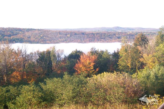
Foggy canal    ...scroll down to share comments
Photos by Brooke Gubacz
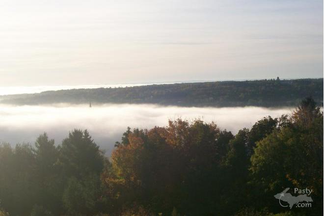
Water fogged    ...scroll down to share comments
Photos by Brooke Gubacz


By
Mary Drew at Pasty Central (Mdrew) on Monday, October 22, 2007 - 03:10 am:

Now that fall is here in the Keweenaw, we have cooler mornings that make for interesting changes in the atmosphere around us. Brooke Gubacz was out and about in the early morning hours recently and was able to capture the fog settled over the Portage Canal, hiding everthing between the cities of Houghton and Hancock. With the white cloud hanging over the water like that, I'd venture to say that the only tough part of the drive to work on a morning like this, would have been crossing the Portage Lake Lift Bridge. I'm guessing it also was hiding in the midst of the fog.


By Gordon Schmitt (Gordy) on Monday, October 22, 2007 - 04:53 am:

Those are nice photos, I think I have something like that from years ago.


By Deb S. (Usedtobeayooper) on Monday, October 22, 2007 - 07:04 am:

They are very nice photos indeed. Great job capturing the beauty and serenity.


By Alex UP-Goldwinger (Alex) on Monday, October 22, 2007 - 07:45 am:

No sign of civilization. They looks like photos from the 1800's.


By Paul LaVanway (Ranger) on Monday, October 22, 2007 - 08:32 am:

In the top or first picture, there is that round (glacial?) hill down near South Range that has a bit of a slice in the side of it---it is a cut which appears to run from the bottom of the hill on up to the top. It almost looks like a clearing in the forest vegetation for a pole line/power line, but somehow, it doesn't intuitively make sense that someone would run a line right over the very top and highest part of a hill. Does anyone know what the "clearing" or "cut" is for &/or why it is there?


By Lorelei (Lorelei) on Monday, October 22, 2007 - 09:14 am:

Paul,
You are looking at Whealkate Bluff. For several years, there were motorcycle races to see who could make it up the hill the quickest. That event used to take place on or around the 4th of July in South Range. Lots and lots of fun.


By dlp (Babyseal) on Monday, October 22, 2007 - 09:15 am:

Paul, The hill in South Range is called Whelakate Bluffs. The clearing down the front that you are referring to was used for hill climbs. I used to walk the clearing picking rocks before the events. I don't think they hold sanctioned hill climbs there any more. Snowmobiliers try to climb the front as well as ATV's in the summer. Tte view from the top is awesome.


By Marianne Y (Marianne) on Monday, October 22, 2007 - 09:59 am:

I love your Portage fog pictures, Brooke! I remember the day you must have taken those pictures because you mentioned how foggy it was on What's UP, so I looked at Mich Tech's web cams. You could not see any evidence that there was a Lift Bridge anywhere that morning. It was really spooky. I also love the sunlight on the autumn trees in the first picture! I am really glad that you had your camera and got pictures of it. Thank you, Brooke and Mary.


By Paul LaVanway (Ranger) on Monday, October 22, 2007 - 10:34 am:

Thanks for the information Lorelei and Babyseal.

Interestingly, after you gave me the name of the hill, I did a "Google" on it & came up with a bit of fascinating history on the name. It turns out "Whealkate" is derived from an 1850's era mining venture at the (same) location. Evidently, "Wheal" is Cornish for "mine", while "kate" was derived from the name of Kate Walback, wife of one of the investors, a Dr. S. S. Walback.

Again, I very much appreciate you sharing your knowledge and insights.


By Brooke (Lovethekeweenaw) on Monday, October 22, 2007 - 12:26 pm:

While crossing the lift bridge there wasn't much evidence of it either! Yet totally clear all around.


By Mr. Bill (Mrbill) on Monday, October 22, 2007 - 12:35 pm:

Here's a brief bio on the Whealkate:

"The first mine opened in the Portage Lake District is claimed to have been the Whealkate Mine, it's location marked by the Whealkate Mountain rising prominently off to the southwest of Houghton. At the time, this upthrust was considered to be the highest point in Michigan.

Being a first, however, was a dubious distinction, for the Whealkate never produced any copper even though considerable shaft sinking and drifting was done over a period of nearly two years. It was finally abandoned in 1853."

In 1902 another failed attempt was made to mine at a cost of $50,000.


By paul (Pungvait) on Monday, October 22, 2007 - 02:39 pm:

the IMpala has been known as the finnlander cadillac for many years now


By paul (Pungvait) on Monday, October 22, 2007 - 02:40 pm:

oops - i posted to the wrong side somehow


By Richard Wieber (Dickingrayling) on Monday, October 22, 2007 - 10:09 pm:

In the first picture, left of center, there is a "v" in the forground tree line. Right above it there seems to be a church steeple sticking out of the fog. Photos are strange and nice.


Powered by:  
Join Today!
Each day the Pasty Cam has 2 areas to post messages: 
  • Cam Notes - comments related to today's picture and discussion
  • What'sUP - other topics, conversation and announcements
  • *** Please use the appropriate forum ***
    Here's a list of messages posted in the past 24 hours
    See our guest photo gallery for more great views from the U.P.

    Add a Message


    A user/password combination is now required to post messages to Cam Notes. Registration is free. Click here to register or maintain your I.D.
    Username:  
    Password:

    Home | Pasty Cam | Contest | Order Now | Bridge Cam | Past-E-Mail | GP Hall of Fame | Making Pasties | Questions