Jul 15-20

Past-E-Mail: Cam Notes - 2020: July: Jul 15-20
Jacobsville Sandstone    ...scroll down to share comments
Photo by E. Neil Harri
Lake Superior Shoreline    ...scroll down to share comments
Photo by E. Neil Harri
Sandstone Cliffs    ...scroll down to share comments
Photo by E. Neil Harri
Jacobsville Lighthouse    ...scroll down to share comments
Photo by E. Neil Harri
Kayaking Jacobsville Sandstone    ...click to play video
See July 15 in the previous 22 years of the Pasty Cam
2019   2018   2017   2016   2015  
2014   2013   2012   2011   2010   2009  
2008   2007   2006   2005   2004  
2003   2002   2001   2000   1999   1998  

By
Mary Drew at Pasty Central (Mdrew) on Wednesday, July 15, 2020 - 08:00 pm:

Retirement hasn’t slowed down the flights and photos that E. Neil Harri, snaps and shares, thanks goodness! He has his own personal plane and was out flying this past week, snapping these photos of the Jacobsville Sandstone cliffs along the Lake Superior Shoreline. You can see the Portage Lower Entry Lighthouse in the upper left of the first three photos, to give you a landmark to locate where these shots were taken.

In the fourth photo you can see the Jacobsville lighthouse with the red roof. It was operated as a Bed and Breakfast until 2019, when one of the owners passed away. I’m not certain of the status at present, but I think it is a private residence now. If anyone has info, please feel free to share.

Two years ago, Jim and I kayaked along the Jacobsville Sandstone cliffs, where I made today’s video. It’s a bit shaky or jumpy in spots, as it was difficult to hold the phone and paddle to stay away from the walls. The layers of sandstone there are quite amazing.


By Capt. Paul (Eclogite) on Wednesday, July 15, 2020 - 08:33 pm:

Copied from yesterday's Cam:

I have a question for Pastyland. Nathalie and I are in the Keweenaw for a few days and are creating little videos called "90 second geology" that will be used for our students, but may also be posted for public viewing. One of the places we are trying to get to is the La Roche Verte (the green copper oxide vein that leads out into the Lake) near the Copper Harbor lighthouse. The issue we're having is gaining access to get photos and create the video. We were up there today, but the access road was posted "private road". I was wondering if anyone knows how we can get access to the vein? You can leave a message here, or send me an email at eclogite@pasty.com

Thanks! ;-)


By Deb S. (Usedtobeayooper) on Wednesday, July 15, 2020 - 09:06 pm:

Beautiful pictures. I love that area. The video
reminds me something of the Apostle Islands and the
kayaking through the tunnels. It looks like so
much fun, but I'm too big a chicken to do that. I
do like kayaking familiar territory, though.


By D. A. (Midwested) on Wednesday, July 15, 2020 - 09:17 pm:

Capt Paul,

The things come to mind if you have time to investigate. Check with the County Treasurer in Eagle Harbor. They can share the public documents regarding who owns the property and access route property. First step to know who to contact. Also I read that the A.E. Seaman Museum did some geographical mapping of the area by land and using scuba teams. Hopefully they can look up or remember their process. Or maybe they will share their results if they are suitable for your needs.

Lastly, as jbuck earlier pointed out, maybe your best shot is by water. Is the lighthouse tour still operating? Even if so, the land from that direction is probably also posted. But maybe you can make friends with another boater or rent a boat or paddle to the area. Can you get anything you want from the water or shoreline? Or maybe enlist a drone? Just don't go over anyone's house.


By D. A. (Midwested) on Wednesday, July 15, 2020 - 09:34 pm:

Capt. Paul,

Or the County Tax Office might now be in Mohawk.


By D. A. (Midwested) on Wednesday, July 15, 2020 - 09:46 pm:

Jacobsville shoreline, the Keweenaw's own Pictured Rocks. Take care of the weather when paddling because there might be nowhere to land.

The sandstone actually extends all the way to the southern side of Bete Grise although there are no spectacular cliffs as further south. Here is a picture of the sandstone shoreline at Brunette Park just south of Point Isabelle.

Brunette Park


By FRNash/PHX, AZ (Frnash) on Wednesday, July 15, 2020 - 10:19 pm:

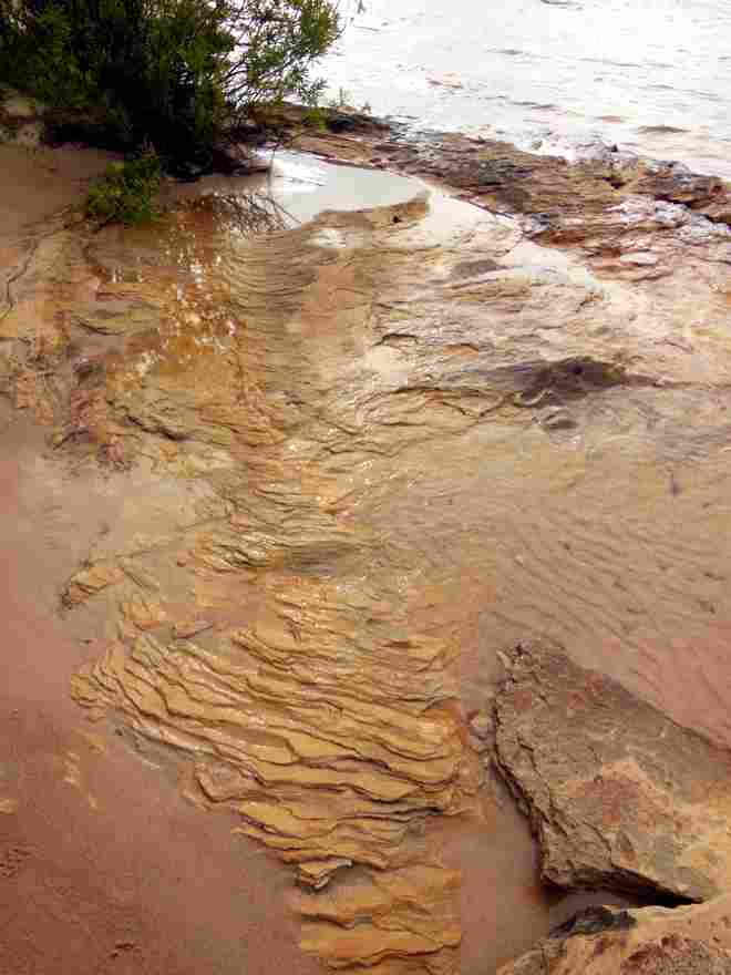
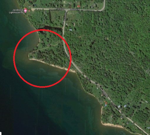
Speaking of Jacobsville Sandstone, does ye olde Pasty Cam have any pictures of any of the “… thirty-two quarries(!) throughout the Upper Peninsula approximately between 1870 and 1915.” (Wickedypedia) where all the sandstone was mined/excavated for all of the buildings that were made of it, like:

  • The Calumet Theatre
  • St. Ignatius Loyola Church in Houghton
  • The Quincy Street Historic District in Hancock
  • The Waldorf Astoria Hotel
and many others?

I don't remember ever seeing any of those quarries!
By
Alex "UP-Goldwinger" (Alex) on Thursday, July 16, 2020 - 06:20 am:

Sweet pix, Mr. Harri...and an excellent video, Mary...you go, girl.


By Bob Williams (Wabbit) on Thursday, July 16, 2020 - 11:09 am:

Capt Paul..I think you could rent Kayaks from
Keweenaw adventure in copper harbor. If I remember
that is near the Copper harbor Light House.


By jbuck (Jbuck) on Thursday, July 16, 2020 - 12:01 pm:

Bob Williams (Wabbit),
That's what i was thinking about too - if the weather cooperates, you could kayak over.


By jbuck (Jbuck) on Thursday, July 16, 2020 - 12:04 pm:

Here's the website:
http://exploringthenorth.com/adventure/company.html


By Capt. Paul (Eclogite) on Thursday, July 16, 2020 - 12:15 pm:

Thanks to all who have replied. I was thinking about the kayak option as well, but I would much rather get land access is possible.


By jbuck (Jbuck) on Thursday, July 16, 2020 - 01:39 pm:

Mary, it appears the lighthouse is now for sale.

Thanks Neil - your pictures are the best! In the first picture, where is that point of land which juts out?


By FRNash/PHX, AZ (Frnash) on Thursday, July 16, 2020 - 04:29 pm:

Cap'n Paul: check your email!


By FRNash/PHX, AZ (Frnash) on Thursday, July 16, 2020 - 04:55 pm:

jbuck (Jbuck):
"… Thanks Neil - your pictures are the best! In the first picture, where is that point of land which juts out?"


Not Neil, but I'm sure this is the point in question:
Jake's
By
jbuck (Jbuck) on Thursday, July 16, 2020 - 05:04 pm:

Thanks Frnash,

And related to your question, it appears that was a dock for one of those quarries:

"http://www.geo.mtu.edu/KeweenawGeoheritage/Sandstone/JVille_Quarries.html"


By FRNash/PHX, AZ (Frnash) on Thursday, July 16, 2020 - 05:22 pm:

Thanks Jbuck, that's a great link!


By D. A. (Midwested) on Thursday, July 16, 2020 - 06:34 pm:

This has been a great discussion. The docks in the Jacobsville area were actually quite long and large. It seems sandstone quarrying has always taken second place to the other mining ventures but the White City/Jacobsville area is rich with history. Unfortunately, the red stone was not immune to the same types of style preferences that come and go that we still see on the HGTV channel. The red stone soon gave way to the grey version found in the quarries of the central U.P. That lasted only until preferences for even lighter tones trending toward yellow and white took over. When the original Waldorf Hotel was torn down (to make room for the Empire State Building) it's replacement standing today ignored it's "red roots".


Powered by:  
Join Today!
You are welcome to comment here or on 
Pasty Central's Facebook page
Here's a list of messages posted in the past 24 hours
See our guest photo gallery for more great views from the U.P.

Add a Message


A user/password combination is now required to post messages to Cam Notes. Registration is free. Click here to register or maintain your I.D.
Username:  
Password:

Home | Pasty Cam | Contest | Order Now | Bridge Cam | Past-E-Mail | GP Hall of Fame | Making Pasties | Questions