Sep 08-16

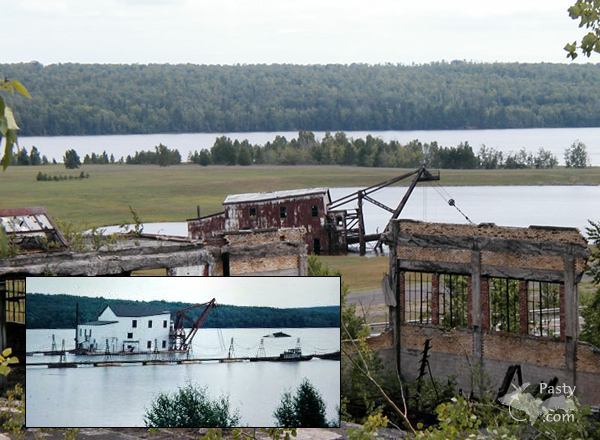
Past-E-Mail: Cam Notes - 2016: September: Sep 08-16
Learning about Jacobsville Sandstone    ...scroll down to share comments
Photos by Don Afman
Tech's Transportation    ...scroll down to share comments
Photos by Don Afman
Jacobsville Sandstone up close    ...scroll down to share comments
Photos by Don Afman
You are Here    ...scroll down to share comments
Photos by Don Afman
The old Lighthouse    ...scroll down to share comments
Photos by Don Afman
More Jacobsville Sandstone    ...scroll down to share comments
Photos by Don Afman
Exploring the shore    ...scroll down to share comments
Photos by Don Afman
Man overboard?    ...scroll down to share comments
Photos by Don Afman
19 years of the Pasty Cam on this day, 1998-2016
1998 1999 2000 2001 2002
2003 2004 2005 2006 2007
2008 2009 2010 2011 2012
2013 2014 2015 2016
Also find us on
facebook
yes Printed on Recycled Internetyes

By
Mary Drew at Pasty Central (Mdrew) on Thursday, September 8, 2016 - 08:23 am:

Don Afman spent two weeks visiting and exploring the Keweenaw and he said the highlight of his trip was the MTU Geo Heritage tours. This is the 3rd year that retired geology Professor Bill Rose has put this together with the help of Erika Vye, a newly minted PhD. Bill is the one in the very colorful and flowery hat and suspenders. It was Don's first time and he did all 4 days.

Today's photos are from day 3, where they examined the area to the east and south of the Keweenaw fault line, which is home to all the famous Jacobsville Sandstone. The participants were given an introduction to the sandstone rock and then they boarded the MTU vessel for the tour of the sandstone cliffs, with a bonus view of the old Jacobsville Lighthouse.

Don said one interesting stop on day 3 was Traverse Island, now commonly called Rabbit Island. When the tour group neared the Island, they were greeted by the new owner of the Island, Rob Gorski and three of the "resident artists" that stayed on this secluded spot out in Lake Superior. They boarded the MTU vessel for lunch and a talk about the Island Resident Artist program. Two of the gentlemen pictured were woodworking craftsmen from New York. Rob has a visiting artist program where they rotate in and out, staying on the Island for a period of time while working on their artistic craft and living quite primitively with no modern conveniences, just a three sided shelter they call home for their time on the Island. This year there were 177 applications from 31 countries to fill the six available slots. Don added that last year an opera was composed on the Island that will be performed by the Helsinki Chamber Choir on September 29th in Marquette. You can learn more about Rabbit Island and the Artist in Residence program by clicking here: RabbitIsland.org.


By jbuck (Jbuck) on Thursday, September 8, 2016 - 08:46 am:

This would be an interesting tour to take! Thanks for the ride and great pictures along the way.


By Deb S. (Usedtobeayooper) on Thursday, September 8, 2016 - 08:46 am:

Very nice pictures. Sounds like a very interesting
way to spend the day.


By Alex "UP-Goldwinger" (Alex) on Thursday, September 8, 2016 - 09:12 am:

What a great way to explore! I'm impressed with all of the senior citizens walking around and enjoying themselves...way to go!


By Greta Jones (Urbanescapees) on Thursday, September 8, 2016 - 01:52 pm:

Interesting stuff here. I especially like the idea of the Island Resident Artist program on Rabbit Island!
A lot of nice shots in the review too.


By D. A. (Midwested) on Thursday, September 8, 2016 - 09:14 pm:

Each of the 4 days of the tour was very interesting. The last two pictures were at Rabbit Island. There is no dock there so our boat had to anchor off shore while the 4 residents came over in their inflatable boat. The 2 guys on the left are the resident artist wood craftsmen. Rob Gorski is next in glasses and his partner Andrew Ranville on the far right. We stopped there to have lunch with them while they explained their program and living conditions.

Later we stopped at the old school house in Jacobsville for coffee and pie while we listened to a very interesting presentation of the history of John Henry Jacobs, Jacobsville and White City by the local historian and one of the few remaining residents (I wish I could remember her name, a little help maybe?). Taking one's boat or catching a ferry from Houghton to White City amusments on the weekend was a favorite leisure pastime back in the day.

It's too bad the several old quarry pits are still closed to the public.


By D. A. (Midwested) on Friday, September 9, 2016 - 02:43 pm:

In the last picture, in addition to the 4 guys
from Rabbit island, the fellow on the far right
with his back to us is Captain Stephen Roblee who
operates the MTU research vessel Agassiz.


By Douglas Johnson (Pixelpaddler) on Saturday, September 10, 2016 - 03:19 pm:

Wish I could have joined this excursion. Several year's ago, launched
at White City Park, paddled around the Lower Entry light and the old
Jacobsville light to the quarry just to its east. Landed and examined
the water-filled hole. Didn’t know it was not “open”! Will post photo
in the Guest Photo Album Gallery.


By D. A. (Midwested) on Saturday, September 10, 2016 - 05:32 pm:

Douglas,

Thanks for the additional info and great picture.

Unless there is a huge section different from this photo, this looks like it was most likely a cutout made to accommodate one of the very large docks and landings for the large ships and barges used to haul the stones. I say this for two reasons. The main one is the quality of rock here is not what they quarried. It has too much of the white sandstone layers. They went after the more solid red stone. Plus it is so close to the shore.

I'm almost certain they will be scheduling similar excursions next year.

Since you're a paddler, here's some interesting paddling links at the Geoheritage website.


By Douglas Johnson (Pixelpaddler) on Sunday, September 11, 2016 - 02:11 pm:

Midwestted,
Thank you for the terrific lead to the Geoheritage website. Many
hours of fruitful exploration ahead! Am familiar with many sites
included but eager to learn more about them and find other places
to visit.

I've uploaded additional images to better show the extent of the
quarry. Agree that the visible stone would have been considered
overburden and removed to gain access to the higher quality
material.

My authority for believing this a quarry is primarily a 1905 War
Department - Corps of Engineers Chart of Portage Entry and River
Lake Superior. I downloaded it from the Library of Congress and
have seen it used elsewhere, for instance on the Geoheritage site
for Jacobsville. It shows a quarry located where I landed and took
the photos.

Clarence Monette in his "History of Jacobsville and its
Sandstone Quarries" (1976) refers to the Portage Entry Quarry and
has numerous photos. It seems to me that what I could see was
only a limited portion of the entire quarry shown in the photos.
Monette refers to this as the earliest quarry, opened in 1883.

Remnants of the Jacobsville Dock also mentioned on the 1905
chart can still be seen in the form of pilings in the water off the
end of the small peninsula. Placement of the dock on the 1905
map and location of the label marking the quarry also seem to
suggest a larger operation than is visible today.

So far, I have not seen any indications of a dock at the location I
landed and photographed but I am always learning.


By D. A. (Midwested) on Sunday, September 11, 2016 - 03:24 pm:

Douglas,

Thank you for the additional photos.
Can you provide the GPS coordinates of this
location?


By Douglas Johnson (Pixelpaddler) on Sunday, September 11, 2016 - 05:14 pm:

Midwested,
First, sorry for misspelling your name.

Second, I make the quarry wall to be 45 deg 58 min
43 sec N; 88 deg 24 min 45 sec W. Sorry I don't have the
decimal form handy.

Finally, browsing the Geoheritage link you gave me, found
several relevant blogs from Copper Country Explorer with
photos and maps. His presentation is that this was indeed
a tiny tip of the Portage Entry Quarry. He has a photo
showing it extended far north of today's Red Rock Rd.
Great info. Thanks again!

Am struggling to learn how this message board works with
line lengths. I'll get it eventually. ;-)


By Douglas Johnson (Pixelpaddler) on Sunday, September 11, 2016 - 05:16 pm:

Grr. My messages look fine in the preview
window but are not displayed online the
same way.


By D. A. (Midwested) on Sunday, September 11, 2016 - 05:54 pm:

Douglas,

Thank you very much. I saw that same area just adjacent to the lighthouse but wasn't sure it was what you referenced. I think you have a typo and the latitude is actually 46 deg. Here is the decimal equivalent: 46.978611 -88.4125

Google Chrome is my preferred browser but it does not work well with this site as it inserts extra line feeds.

As for other other formatting features that work here check this reference.


By Douglas Johnson (Pixelpaddler) on Sunday, September 11, 2016 - 10:30 pm:

Midwested,

Duh. 45 deg couldn't possibly have been right, eh?
Worried about carriage returns and line feeds and
overlooked content. Thanks for the catch.

Still don't find help on handling lines in the referred
article but thanks for the link. Will seek assistance
from Charlie or Mary.

Generally using Safari for browser but will try in Firefox.


Powered by:  
Join Today!
You are welcome to comment here or on 
Pasty Central's Facebook page
Here's a list of messages posted in the past 24 hours
See our guest photo gallery for more great views from the U.P.

Add a Message


A user/password combination is now required to post messages to Cam Notes. Registration is free. Click here to register or maintain your I.D.
Username:  
Password:

Home | Pasty Cam | Contest | Order Now | Bridge Cam | Past-E-Mail | GP Hall of Fame | Making Pasties | Questions