May 06-05

Past-E-Mail: Cam Notes - 2005: May: May 06-05
Au Sable Point Lighthouse    ...scroll down to share comments
Photos by Tom Cook
Shipwrecked    ...scroll down to share comments
Photos by Tom Cook


By
Mary Drew at Pasty Central on Friday, May 6, 2005 - 05:41 am:

Tom Cook has captured a duo of pictures showing the Au Sable Point Lighthouse and the main reason for the beacon's existence, the remains of a shipwreck that washed ashore near the light. For those of you wondering, this lighthouse is located on the shores of Lake Superior, between Whitefish Bay and Grand Island. In the 1800's, this stretch of shoreline was known as 'The Shipwreck Coast' to mariners, being that there are a number of ships which met their end on the rocky skirts of this strip of land during storms. Tom's second shot gives us a look at what seems to be the wreckage of one of those unfortunate ships. I'm hoping someone can identify which ship it was and how long it's been here on these shores. Those spines of the hull are a reminder to all of the importance lighthouses play in Maritime history, for without these beacons of the night, there would be many more skeletons of ships such as this.


By smf in troll land on Friday, May 6, 2005 - 05:50 am:

This is one lighthouse I haven't seen but hope to. The second picture is eerie - will be interesting to see if someone can identify it. Happy weekend & Mother's Day!


By Beverly, San Jose on Friday, May 6, 2005 - 05:52 am:

Interesting pictures. Good morning from San Jose. We had some heavy rain, lightning and thunder last night. First time in years, it seems. (Of course, I am refering to the lightning and thunder.) 2:58 am, time to rise and shine. :)


By Caitlin, Ohio on Friday, May 6, 2005 - 06:00 am:

Good morning from Columbus. As usual great pictures. The weather here will be sunny and 70 degrees. This site keeps all of us UP wanna-be's going till our next trip.


By Mary, NWOh on Friday, May 6, 2005 - 06:37 am:

We enjoyed our visit to this lighthouse very much. I think its somewhat open to the public now, but it wasn't then. You have to park at a campground and walk a mile or so through the woods, but then you come out into the clearing where these magnificent buildings stand. I found some wild blueberries there too. Thanks for sharing and bringing back a nice memory for today. Have a nice day, everyone.


By Susan, Fl on Friday, May 6, 2005 - 06:43 am:

Just wondering...how did it get there? Shipwrecked on the shore or just left there or washed ashore....makes you wonder about those who may have been aboard....maybe they should have kept a chary eye on the lighthouse!


By Margaret, Amarillo TX on Friday, May 6, 2005 - 06:45 am:

Love the shots. What memories this old house must have.


By Cindy, St. Clair Shores, Mi on Friday, May 6, 2005 - 07:04 am:

Nice pictures, Tom. This is one of my absolutely favorite places! I have walked that beach from the Hurricane River Campground to the lighthouse. It is so interesting. I have more pictures of this light including views from the tower and also the shipwrecks which were very eerie to see in my guest gallery if you are interested. They are in the "Grand Marais" album and more in my "Michigan Lighthouses" album. Next to the Keweenaw, of course, this is one of the most beautiful areas in the state.

https://pasty.com/pcam/Melladie


By Janie, IA. on Friday, May 6, 2005 - 08:05 am:

Beautiful pics there! Thankyou for sharing them and for the little history lesson as well!


By Kathy from Whitmore Lake/Cheboygan on Friday, May 6, 2005 - 08:07 am:

I have been up in that lighthouse, on a ranger-guided tour (it's on Pictured Rocks National Lakeshore). The view from the top shows a vast sheet of sandstone under the water; seeing those reefs, you understand the shipwrecks.

Speaking of that tour, the lighthouse was being renovated at the time. One of the workmen, apparently unaware that anyone was up top, shut and locked the door leading to the tower. Our cries for help, out on the balcony, were eventually answered. No Rapunzels among us.


By Marsha, Genesee/Aura on Friday, May 6, 2005 - 08:16 am:

Time to wake up, boatnerds!


By Susan ...Wisconsin on Friday, May 6, 2005 - 09:02 am:

hey ...I'll soon be bare foot on the beach at Misery bay ...I'll keep my eye out for shipwrecks!!! Happy Spring!


By Tom on Friday, May 6, 2005 - 09:20 am:

There was a sign there noting what ships were washed ashore. Don't know what one this is. Would be tough to guess seeing they list 5 or 6 that washed ashore. And this 1/4 mile stretch looks like it has 4 different ones here yet. There is one more right at the beach at the Hurricane Campground, where I started in.


By sur5er on Friday, May 6, 2005 - 09:26 am:

Beautiful pics Tom. What I wouldn't give to be walking those shores right now. Sigh.

There are three shipwrecks along this stretch. The first one is the Mary Jerecki which lost its way in fog July 4, 1883 at Au Sable Reef. The second shipwreck is the Sitka, which went down October 4, 1904 in a gale. The third is the Gale Staples, another victim of a gale October 1, 1918.


By MissingdaUPinMN on Friday, May 6, 2005 - 09:53 am:

Beautiful Pictures! I sure enjoyed Cindy's pics of the Keweenaw and surrounding areas! Sure made me homesick for my old home town!


By Alex Tiensivu, Georgia on Friday, May 6, 2005 - 10:15 am:

What pix, and history, as well. I'll have to make this a wallpaper! The wreak is very eerie.

HAHA! I guess you could say, SUPERIOR pictures and ERIE wreaks! (Getting ready for the nasty-grams to follow).


By Carole on Friday, May 6, 2005 - 10:45 am:

Alex: It should be Erie wrecks (not wreaks)but this is NOT a nasty gram.


By UP dreamer stuck in NJ on Friday, May 6, 2005 - 10:47 am:

2 months & 2 days from today I will be at this lighthouse! I can't wait! I walked the beach & saw the shipwrecks as a kid, but haven't ever been all the way to the lighthouse before. The campground where you have to park is called Hurricane River, and is one of my favorite places in the world...absolutely gorgeous.

After Grand Marais, I will be headed to the Keweenaw for the first time. Hope to see all the places I've seen photographed on Pasty Cam!


By Kristin, MA on Friday, May 6, 2005 - 11:17 am:

Alex: I don't understand your comment, "SUPERIOR pictures and ERIE wreaks! (Getting ready for the nasty-grams to follow)." Please explain; I'm lost!


By Marsha, Genesee/Aura on Friday, May 6, 2005 - 11:28 am:

Are we talking about wreaks, reeks or wrecks?


By sur5er on Friday, May 6, 2005 - 11:29 am:

Kristin: Erie= Lake Erie ;)


By J.T. on Friday, May 6, 2005 - 11:37 am:

Alex got a little excited!


By John / New Hampshire on Friday, May 6, 2005 - 12:04 pm:

I really like today images - the lighthouse with all those out buildings under the big blue sky is great. But I have to question (and I do question everything - especially the government,.......) whether or not the wood and re-bar structure in the shoreline image are really the remains of a ship?? I am no naval architect but the construction seems odd for a ship. Could it be part of a pier or rock box that has been broken off and washed ashore?? Any ship construction experts out there today please "chine" in.


By Frank,,,,,,Milw..... on Friday, May 6, 2005 - 12:18 pm:

So Alex and sur5er are one and the same.... I'll be darned....... Learn something new every day..


By Stix out West on Friday, May 6, 2005 - 12:21 pm:

I agree, it looks like the remains of a dock....there are many of those in the UP, usually good fishing off of them if the water is deep enough! But the shipwreck (wreak, reek)story sounds better!!
Have a great day and weekend!


By smf in troll land on Friday, May 6, 2005 - 12:22 pm:

Cindy - I just looked at all your albums - great pictures! Thanks & have a nice weekend.


By tom t c mich on Friday, May 6, 2005 - 12:32 pm:

Check this out...go to google maps type in grand marais...go to sattellite view...zoom in and explore the shoreline...


By tommy,mi on Friday, May 6, 2005 - 01:25 pm:

When I was there in the late 1970s, the water level was much higher and the remains were hard to see.

Looks like a new trip is in order.


By LZ, MI on Friday, May 6, 2005 - 01:43 pm:

tom tc mich, thanks so much. Too cool!


By howd'ya figure that? on Friday, May 6, 2005 - 01:50 pm:

Alex and sur5er are two different people.


By AL in WI on Friday, May 6, 2005 - 01:53 pm:

tom tc mich: Help! I can't find it. Please help with more instructions. I go to Google, but don't find "maps". Would you run it by me again?
(I am not very good at this.)


By bad punster on Friday, May 6, 2005 - 02:07 pm:

Alex, you missed one: They are SUPERIOR pictures of ERIE wrecks HURON the beach!


By sur5er on Friday, May 6, 2005 - 02:32 pm:

They are SUPERIOR MICHIGAN pictures of ERIE wrecks ONTAR(IO), HURON the beach.


By LZ, MI on Friday, May 6, 2005 - 02:49 pm:

Al in WI, try typing in google maps on the google search bar. That should take you to google maps.


By Audrey, San Jose, CA on Friday, May 6, 2005 - 05:27 pm:

Al in WI... Try this:
http://www.maps.google.com


By allouezandre@PHX AZ on Friday, May 6, 2005 - 07:06 pm:

Here's an interesting link about other shipwrecks in the northen UP

http://www.ship-wrecks.net/shipwreck/keweenaw/


By FLYINDAMOONEY on Friday, May 6, 2005 - 07:42 pm:

This site is my "pillow".....the place I stop first on my computer catch up of the day.....I have no access during the day, so this is what I look forward to each evening.....plus a beer of course.......thanks Charlie and his minions....


By julie b., MI on Friday, May 6, 2005 - 09:07 pm:

Sure wish i could share the pleasant memories so many people have of this lighthouse!

We hiked out from Hurricane many years ago before the light was restored. It was a cold morning and we were wearing sweats, but 'sprayed up' before we took off. It didn't matter - within a few hundred feet we were swarmed by black flies. The back of my husband's sweatshirt was black with flies.

We decided to hike along the lake shore - where the breeze helped a little, but not much. The flies were mericless and we grabbed a few shots of the lighthouse before hiking back along the road. The morning had turned warm, but we didn't dare expose our bare arms, and that made it even more miserable. We met several other people in the same misery.

Someday we will have to go back and experience a pleasant visit to the restored lighthouse & grounds - but i think the only way my husband would be game is if there was snow on the ground!


By Joyce T Toivola on Friday, May 6, 2005 - 10:04 pm:

Wow! That's quite a skeleton. Interesting pictures! There is a similar sunken structure,though much smaller,between Agate Beach and the Lots.
My mother would tell us kids to stay away from there. Years later I warned my own kids about the danger just below the surface. I've always wondered what story lies beneath.


By AL in WI on Friday, May 6, 2005 - 10:31 pm:

Audrey and LZ: I'm back now. Thanks for your help.....now I have it. Such guru's we have at this website. THANK YOU!!


By Jack Hart, Michigan on Friday, May 6, 2005 - 10:52 pm:

Hi, Lois Hart
Are you checking this out...out there on Catalina Island?


By Stix out West on Friday, May 6, 2005 - 11:20 pm:

Joice T Toivola.....where is the place you are referring to....between Agate Beach and The lots??? Never heard of it. Amazing what we are told and beleive as kids.....and then pass on!!! Always looking for another beach to walk!
Thanks


By 7707 on Saturday, May 7, 2005 - 07:19 am:

Good Saturday morning all,
Two Friends and I were just at the Au Sable point Lighthouse in March of this year on sleds. The place look beautiful dressed in white and there was'nt a soul around. Had know idea we were parked on top of that ship wreck on the shore. Good thing it was covered with ice and snow, Talk about track killers. Take care and have a great day. steve


By Tim, Saint Clair Shores, MI on Saturday, May 7, 2005 - 04:49 pm:

To get a bird's-eye perspective of the Munising and Grand Island area shipwrecks, I highly recommend taking the air tour from Hanley Airport, just south of Munising. You fly at a low enough altitude to see the detail of the different shipwrecks and high enough to get the big picture perspective.

The tour was well worth it and you will then want to see these sights from ground level afterward. This is not a paid endorsement, by the way.


By chaz on Wednesday, May 11, 2005 - 10:44 am:

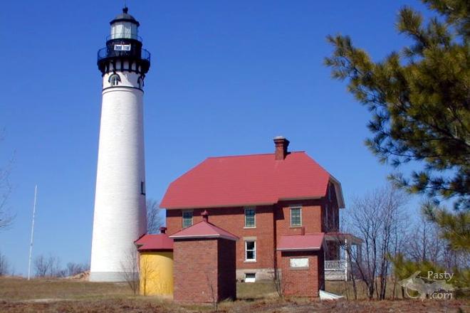
Couldn't resist adding a word about the AuSable LH. I worked there for 2 weeks one summer about 10 years ago as a NPS historic restoration specialist. We documented then removed the 1930's USCG concrete porch from the Keeper's Quarters and reconstructed/restored the wooden porch, columns, steps and railings to the site's interpretive 1916(?) time period. Another time we restored the metal cone-shaped (copper)tower roof, lantern room windows and removed all the old lead paint from the interior circular stairs.It was a great job in a fantastic place; I'll always remember that summer, including the bears and blueberries.


By Thomas Baird (Thomas) on Saturday, October 4, 2008 - 10:01 am:

It's great 2 c lighthouses being preserved. Always a subject 4
picture taking.


By Mary Drew at Pasty Central (Mdrew) on Tuesday, August 6, 2019 - 09:51 am:

This archive discussion page is closed to new comments, see the current Pasty Cam.