Copper Range Railroad
Engineering Department
List of Buildings & Bridges
Houghton, Mich.
Sept. 14th, 1916
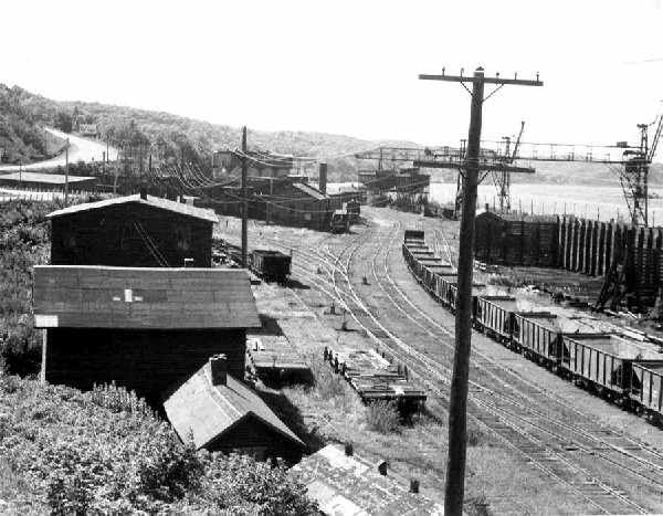
Copper Range Houghton Yard, looking west. (Paul Meier Collection)
FORWARD
More often than not, the study of a railroad's history focuses on the rolling stock and
motive power that it possess. Land locked assets (structures) of a railroad were just as
important as the equipment that move products and services from one point to another. The
Copper Range Railroad was no exception. The 60 mile mainline of the railroad cuts through
the center of the Keweenaw Peninsula and contacts all the major centers of mining and
industry the area has to offer. Copper Range built more than two ribbon of steels to
connect this region, they also built infrastructure to support this mode of
transportation.

The following list of bridges,
buildings, water tanks, etc is a glimpse into the Copper Range from the time of its birth
through the good years and nearing the peak of operation in the early 1920's. Passenger
service was active at this time running at least 15 scheduled passenger trains per day on
the mainline and 8 down and back the Lakeshore branch, not including the Freda park train
and the school train. The data allows you to see the early development of the railroad in
1899-1900 building from Mass Junction (McKeever) to Houghton. The addition of the
Lakeshore branch and the completion of the Copper Range mines and mills in 1902. The
completion of the line to Calumet as well in 1902, all seen in the build dates of the
structures along the mainline and branchlines. 1912 and 1915 being two years of heavy
additions and/or repairs as the railroad matures. This is prior to the time the Copper
Range aquired the Mineral Range's line to Gay so that section of the line is not included
in this report.
The information within the tables were
taken from the Copper Range report to the I.C.C. in 1916. The information regarding the
stations was taken from a 1915 Copper Range Timetable, so populations are correct for that
time period. I have added links where ever possible to point to photos or further
information on the structure or the area. Thank you to Paul Meier for some of the
Copper Range photos shown here, I finally found a nice place to put them, thanks Paul.
(Kevin Musser, February 2002)
Copper Range Greenland Depot (Kevin Musser Collection)
(Click here for a photo of this building today)
1916 Copper Range Bridge
& Building Index
Water
Stations
Bridges
Stations/Locations
Under Crossings

Period Map of the time of this report
Water
Stations of the Copper Range
| Location |
Size |
Pump Equipment |
Tank Built |
Pump Installed |
Repairs |
| Calumet Jct. |
16'x24' |
Steam |
1903 |
1908 |
|
| Point Mills Jct. |
16'x18' |
Gravity |
1903 |
|
|
| Houghton |
16'x18' |
Steam |
1899 |
1899 |
1914 |
| Mill Mine Jct. |
16'x24' |
Gravity |
1901 |
|
|
| Mill Mine Jct. |
16'x24' |
Gravity |
1905 |
|
|
| Stonington |
16'x24' |
Steam then Oil |
1899 |
1899-1911 |
|
| Lake Mine |
16'x24' |
Steam & Gravity |
1905 |
1910 |
|
Bridge List of the Copper Range
The higher the bridge number the further
north you are. No. 30 is near Calumet, No. 16 is the bridge over the Portage Canal, No. 4,
No. 3 and No. 2 are the three steel bridges over the Firesteel River, near Lake Mine. All
except for 57, 55 and 63, not sure why they were given these numbers. The remarks in italics
are my comments and are not part of the original report but have been added to help better
understand where the bridges were located, or at least my best guess. Links have been
added to guide you to photos of these bridges from my collection.

Bridge #55
Reinforced Concrete Slabs used for a bridge (left) over the Copper Range mainline in
Painesdale
Mainline Bridges
| No. |
Station |
Description |
Length |
Date |
Remarks |
| 30 |
320 |
Steel & Concrete Trestle Ballasted |
|
1910 |
|
| 29 |
338 |
Steel & Concrete Girders |
337' |
1911 |
@ Douglass Houghton Falls |
| 22 |
467 |
Steel & Concrete Girders |
184' |
1911 |
|
| 21 |
484 |
Framed |
30' |
1902 |
|
| 19 |
579 |
Thru Girder Steel |
77' |
1902 |
|
| 18 |
665-50 |
Pile |
15' |
1902 |
|
| 17 |
876 |
Pile |
205'7" |
1902 |
Hancock? |
| 16 |
891 |
Pony Trusses & Draw |
807' |
1902-5 |
Part Joint Owner |
| 15 |
930-50 |
Concrete Slabs |
22' |
1909 |
Houghton Yard |
| 14A |
991 |
Thru Girders Steel |
145'4" |
1908 |
over Old Mill Road |
| 14 |
993 |
Steel Trestle Ballasted |
156'5" |
|
Traprock Valley |
| 57 |
1439 |
Temporary Pile (Washout) |
96'5" |
1905-12 |
near Trimountain? |
| 55 |
1469 |
Reinforced Concrete Slabs |
213" |
1913 |
behind hoisthouse in Painesdale |
| 63 |
2010 |
Pile |
|
1912 |
Built for Stratton |
| 11 |
2299 |
Deck Girder Ballasted |
46'3" |
1907 |
near Seager? |
| 4 |
2881 |
Steel & Concrete Trestle |
516' |
1899-1910 |
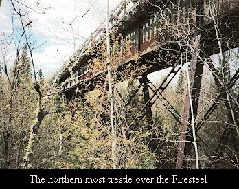
Firesteel River |
| 3 |
2889 |
Steel & Concrete Trestle |
597' |
1899-1910 |
Firesteel River |
| 2 |
2895 |
Steel & Concrete Trestle |
554' |
1899-1910 |
Firesteel
River |
Lakeshore Branch
Bridges
| No. |
Station |
Description |
Length |
Date |
Remarks |
| 36 |
0-50 |
Framed Trestle |
77'9" |
1901 |
|
| 37 |
Freda Mill |
Framed Trestle |
154'5" |
1902 |
|
| 38 |
Freda Mill |
Framed Trestle |
117' |
1902 |
|
| 39 |
Trimountain Mill |
Framed Trestle |
77'9" |
1902 |
|
| 40 |
52 |
Deck Girders |
445'3" |
1913 |
Owner Trimt Mine |
| 41 |
52 |
Steel Trestle |
441' |
1906 |
RR owns one-third |
| 42 |
Edgemere |
Framed Trestle |
500' |
1902 |
|
| 43 |
Edgemere |
Framed Trestle |
172'5" |
1902 |
|
| 58 |
Redridge |
Steel Deck Girder Ballasted |
40'5" |
1911 |
Owner Baltic Mine |
| 59 |
Redridge |
Framed Trestle |
100' |
1915 |
|
| 44 |
271 |
Steel Deck Girders Ballasted |
139'5" |
1909 |
|
Point Mills Branch
| No. |
Station |
Description |
Length |
Date |
Remarks |
| 62 |
15 |
Pile |
45' |
1909 |
|
Smelter Branch
| No. |
Station |
Description |
Length |
Date |
Remarks |
| 60 |
Bosch Brewery |
Pile |
130'3" |
1904 |
|
| 61 |
Cable Track |
Framed |
154'5" |
1904 |
|
Trimountain Mine
Tracks
| No. |
Station |
Description |
Length |
Date |
Remarks |
| 50 |
|
Framed Trestle |
361'3" |
1900 |
|
| 55 |
|
Framed Trestle |
250'6" |
1902 |
|
| 54 |
|
Framed Trestle |
230' |
1902 |
|
Stations and Locations on the Copper Range
Calumet Station #61,
0 miles from Calumet
Population 30,000. This is the
largest village in the district, and is the home of the Calumet & Hecla Mining
Company, whose mines, as well as those of the Tamarack and Osceola companies surround the
location. In th e immediate vicinity are also located the following mining properties:
Centennial, Kearsarge, Wolverine, Allouez, Ahmeek, Mayflower, Old Colony and LaSalle. This
is the terminus of the Keweenaw Central, running from Calumet through Copper City, Mohawk,
Ojbway, Phoenix and Delaware to Mandan.
| Building |
Type |
# of Stories |
Approx. Size |
Build Date |
Major Repair |
| Depot |
Frame |
1 |
19' x 65' |
1902 |
|
| Warehouse #1 |
Frame |
1 |
24' x 120' |
1902 |
|
| Warehouse #2 |
Frame |
1 |
52' x 250' |
1902 |
1912 |
| Warehouse #3 |
Frame |
1 |
52' x 112' |
1908 |
1912 |
| Boiler house |
Frame |
1 |
? |
? |
|
| Ice house |
Frame |
1 |
20' x 30' |
? |
|
| Engine house |
Frame |
1 |
20' x 127' |
1908 |
1908 additions |
| Tool house |
Frame |
1 |
12' x 14' |
1910 |
|
Calumet Junction
Station #59, 2 miles from Calumet
This is the junction from the
Mainline to Laurium.
| Building |
Type |
# of Stories |
Approx. Size |
Build Date |
Major Repair |
| Depot |
Frame |
1 |
12' x 16' |
1902 |
|
| Section house |
Frame |
2 |
Standard |
1903 |
|
| Tool house |
Frame |
1 |
10' x 10' |
1902 |
|
| Privy |
Frame |
1 |
Standard |
1902 |
|
LAURIUM BRANCH (FROM CALUMET JUNCTION)
Laurium
Population 11,000. A busy villate
adjoining Calumet and containing many beautiful homes, its residence section having
attracted a great many of Calumet's business men.
| Building |
Type |
# of Stories |
Approx. Size |
Build Date |
Major Repair |
| Depot |
Frame |
1 |
19' x 68' |
1902 |
|
| Warehouse |
Frame |
1 |
24' x 60' |
1902 |
|
Lake Linden Station
#57, 6.4 miles from Calumet
A thriving village of 4,000
population, adjacent to a growing agricultural district, and the home of the large stamp
mills and regrinding plant of the Calumet & Hecla Mining Company.
| Building |
Type |
# of Stories |
Approx. Size |
Build Date |
Major Repair |
| Depot |
Frame |
2 |
20' x 34' |
1902 |
|
| Warehouse |
Frame |
1 |
18' x 42' |
1902 |
|
| Section house |
Frame |
2 |
Standard |
1902 |
|
| 2 Tool houses |
Frame |
1 |
10' x 10' |
1902 |
|
| 3 Privies |
Frame |
1 |
Standard |
1902 |
|
Grove Station #57,
7.0 miles from Calumet
| Building |
Type |
# of Stories |
Approx. Size |
Build Date |
Major Repair |
| Shelter Shed |
Frame |
1 |
12' x 16' |
1902 |
|
Hubbell Station #55,
8.1 miles from Calumet
Population 2,000. Location of the
Calumet & Hecla Smelting Works and Coal Docks. The Ahmeek Stamp Mill is but a short
distance from here.
| Building |
Type |
# of Stories |
Approx. Size |
Build Date |
Major Repair |
| Depot |
Frame |
1 |
Standard |
1916 |
|
| Privy |
Frame |
1 |
Standard |
1916 |
|
Mills Station #55,
9.2 miles from Calumet
Tamarack and Osceola Stamp Mills
and regrinding plant.
| Building |
Type |
# of Stories |
Approx. Size |
Build Date |
Major Repair |
| Shelter Shed |
Frame |
1 |
12' x 16' |
1902 |
|
Mason Station #54,
11.1 miles from Calumet
Coal docks and stamp mills of the
Quincy Mining Company. Terminus of the Qunicy & Torch Lake Railroad.
| Building |
Type |
# of Stories |
Approx. Size |
Build Date |
Major Repair |
| Shelter Shed |
Frame |
1 |
12' x 16' |
1902 |
|

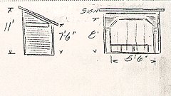
Mason Shelter Shed (ICC sketch)
Point Mills Junction
| Building |
Type |
# of Stories |
Approx. Size |
Build Date |
Major Repair |
| Interlocking Shed |
Frame |
1 |
10' x 12' |
? |
|
| Section house |
Frame |
2 |
14' x 40' |
1907 |
Bought 1909 |
| Tool house |
Frame |
1 |
10' x 12' |
1909 |
|
| Privy |
Frame |
1 |
Standard |
? |
|

Point Mills Section house (ICC Sketch)
SENTER BRANCH (FROM POINT MILLS
JUNCTION)
Senter
Powder plant of the Atlas Powder
Company.
| Building |
Type |
# of Stories |
Approx. Size |
Build Date |
Major Repair |
| Tool house |
Frame |
1 |
10' x 12' |
? |
|
Dollar Bay Station #50,
13.3 miles from Calumet
A village of 2,000 population,
where a wire mill, saw mill and the Lake Superior Smelting Works are located.
| Building |
Type |
# of Stories |
Approx. Size |
Build Date |
Major Repair |
| Depot |
Frame |
1 |
20' x 40' |
1903 |
1916 |
| Privy |
Frame |
1 |
Standard |
? |
|
Ripley Station #49,
15.6 miles from Calumet
The Quincy Smelting Works are
located here.
| Building |
Type |
# of Stories |
Approx. Size |
Build Date |
Major Repair |
| Shelter Shed |
Frame |
1 |
10' x 12' |
1902 |
|
Hancock Station #48,
16.7 miles from Calumet
Population 10,000. Situated on
Portage Lake, opposite Houghton, with which it is connected by bridge. The Hancock Mine
and Quincy Mine are located just outside of the city limits. Hancock boasts the reputation
of being the only city in the Copper County, all other localities being villages.
| Building |
Type |
# of Stories |
Approx. Size |
Build Date |
Major Repair |
| Depot |
Frame |
1 |
19' x 65' |
1902 |
|
| Warehouse |
|
|
Leased |
|
|
| Tool house |
Frame |
1 |
Standard |
? |
|
| Oil house |
Frame |
1 |
|
1905 |
|
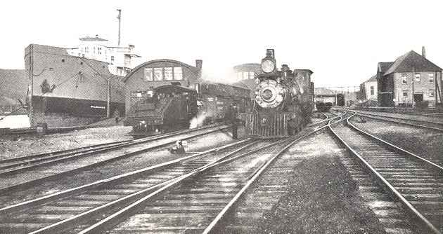
Houghton Station #47,
17.1 miles from Calumet

Copper Range Coal Docks and Coal Unloading Towers, Houghton Yard
(Paul Meier Collection)
Population 8,000. The county seat
of Houghton County, located on Portage Lake, having dock facilities for the largest lake
steamers which ply through this waterway between the Soo and Duluth. The large passenger
steamers of the Great Lakes Transit Corporation land at the Copper Range Railroad docks,
bringing thousands of visitors to the Copper Country annually. The Michigan College of
Mines, a State institution, with national reputation, is also located here. Among the
prominent buildings are the Houghton Club, Masonic Temple and the Douglass Hotel. The
hotel facilities are always an agreeable surprise to visitors. The Michigan Smelting
Company, Isle Royale and Superior Mines are located within a mile or two.
| Building |
Type |
# of Stories |
Approx. Size |
Build Date |
Major Repair |
| Depot/Office |
Brick |
2 |
32' x 104' |
1902 |
1909 |
| Warehouse #1 |
Frame |
1 |
30' x 250' |
1903 |
1915-1916 |
| Warehouse #2 |
Frame |
1 |
60' x 100' |
1903 |
1915-1916 |
| Generator House |
Frame |
1 |
16' x 60' |
1903 |
|
| Electrical Shop |
Frame |
1 |
16' x 31' |
1910 |
|
| Derrick Shed |
Frame |
1 |
|
|
|
| Agents house |
Frame |
2 |
32' x 36' |
1902 |
|
| SuptB&B? house |
Frame |
2 |
15'x15'-26'x26' |
1908 |
|
| Motor Car Shed |
Frame |
1 |
10' x 46' |
1910 |
|
| Tool house |
Frame |
1 |
Standard |
|
|
| Ice house |
Frame |
1 |
20' x 26' |
1903 |
|
| Carpenter Shop |
Frame |
2 |
34' x 56' |
1911 |
|
| Tool Storehouse |
Frame |
1 |
34' x 60' |
1908 |
|
| Paint Storehouse |
Frame |
1 |
14'x16'-10'x12' |
1908 |
|
| Gas Shed |
|
|
|
|
|
| Valve Shed |
|
|
|
|
|
| Sand house |
Frame |
1 |
17' x 26' |
|
|
| Oil house |
Brick |
1 |
12' x 24' |
|
|
| Car Shop |
Brick |
1 |
35' x 126' |
1911 |
|
| Car Shop |
Brick |
1 |
24' x 148' |
1911 |
|
| Storehouse |
Brick |
1 |
52' x 86' |
1899 |
|
| Switchmans house |
Frame |
1 |
14' x 16' |
|
|
| Lamp house |
Frame |
1 |
8' x 10' |
|
|
| Cl Dk Shed |
Frame |
1 |
10' x 12' |
|
|
| Work Crane house |
Frame |
1 |
16' x 48' |
1910 |
|
| Machine Shop |
Frame |
1 |
68' x 100' |
1902 |
|
| Machine Shop |
Frame |
1 |
22' x 60' |
1902 |
|
| Blacksmith Shop |
Frame |
1 |
24' x 54' |
1902 |
|
| Blacksmith Shop |
Frame |
1 |
16' x 22' |
1902 |
|
| Roundhouse |
Brick |
1 |
15 stalls |
1900 |
9 stalls |
| Roundhouse |
Brick |
1 |
|
1904 |
6 stalls, 1912 |
| Section house |
Frame |
2 |
18'x34'-13'x16' |
|
|
| Privy |
Frame |
1 |
Standard |
|
|
| Storage Baggage Car |
Frame |
1 |
|
10/1912 |
|
| Hose house |
Frame |
1 |
7' x 10' |
|
|
| Cinder Pit |
|
|
|
1899 |
1904, 1907, 1915 |
| Yard Track Scale |
Steel |
Fairbanks |
50' 100 ton |
1909 |
|
| Coal Track Scale |
Steel |
Fairbanks |
36' 100 ton |
1909 |
|
| Coaling Dock |
Timber/Pile |
|
16,000 tons |
1901 |
1903, 1909 |
| Coal Unloading Towers |
Steel |
3 towers |
183' |
1901 |
1902, 1903 |

Houghton Sand house (ICC Sketch)
SMELTER BRANCH (FROM HOUGHTON)
Atlantic Sands 2 miles west of Houghton on Smelter Branch
The Michigan Smelting Company is
located here.
| Building |
Type |
# of Stories |
Approx. Size |
Build Date |
Major Repair |
| Ice house |
Timber |
1 |
28' x 52' |
1910 |
|
| Iron house |
Frame |
1 |
24' x 120' |
1902 |
|
Atlantic Station #44,
22.10 miles from Calumet
Location of the Atlantic Mine and
the D.A. Stratton Handle Company, manufacturers of broom handles, chair stock , etc.,
whose products go to all parts of the United States.
| Building |
Type |
# of Stories |
Approx. Size |
Build Date |
Major Repair |
| Depot |
Frame |
1 |
24' x 62' |
1900 |
|
| Privy |
Frame |
1 |
Standard |
|
|
| Coal Shed |
Frame |
1 |
Standard |
|
|
Mill Mine Junction
Station #43, 23.6 miles from Calumet

(MTU Archives & Copper Country Historical Collections)
The Junction of the Copper Range
Mainline and the Lakeshore Branch.
| Building |
Type |
# of Stories |
Approx. Size |
Build Date |
Major Repair |
| Depot |
Frame |
2 |
20'x54'-19'x24' |
1900 |
1912 |
| Section house |
Frame |
2 |
20'x28'-18'x20' |
1900 |
1906 |
| 2 Car Repair house |
Frame |
1 |
12'x30'-18'x24'' |
1902 |
|
| 2 Tool houses |
Frame |
1 |
9' x 10' |
|
|
| Shovel Shed |
Frame |
1 |
20' x 76' |
1909 |
|
| 3 Privies |
Frame |
1 |
Standard |
|
|
| 2 Coach Bodies |
Frame |
1 |
used as shops |
|
|
| Coaling Station |
Timber |
|
10,000 ton |
1908 |
|
South Range Station
#42, 24.7 miles from Calumet
A busy village of 2,000
inhabitants and the location of the Baltic Mine, another property of the Copper Range
Company. This village has been steadily growing, having a bank, numerous stores, lumber
yard, etc..
| Building |
Type |
# of Stories |
Approx. Size |
Build Date |
Major Repair |
| Depot |
Frame |
2 |
30' x 62' |
1900 |
|
| Flagman Shed |
Frame |
1 |
6' x 8' |
1902 |
|
| Tool house |
Frame |
1 |
9' x 10' |
1908 |
|
Trimountain Station
#41, 26.6 miles from Calumet
Location of the Trimountain Mine,
another of the Copper Range Company's properties. At this point the Copper Range Hospital
is located.
| Building |
Type |
# of Stories |
Approx. Size |
Build Date |
Major Repair |
| Depot |
Frame |
1 |
18' x 92' |
1900 |
|
| Privy |
Frame |
1 |
Standard |
1902 |
|
Painesdale Station #40,
27.6 miles from Calumet
The principal mining location of
the Copper Range Company's mines, the general offices being at this point, as well as the
Champion Mine, one of the heaviest producers in the Copper Country.
| Building |
Type |
# of Stories |
Approx. Size |
Build Date |
Major Repair |
| Depot |
Frame |
1 |
20' x 24'-? |
1900 |
1912 |
| Section house |
Frame |
2 |
16'x34'-13x18' |
1900 |
|
| Tool house |
Frame |
1 |
9' x 10' |
1900 |
|
| 2 Privies |
Frame |
1 |
Standard |
|
|
| Engine house |
Frame |
1 |
20' x 80' |
|
|
Toivola
Station #33, 33.9 miles from Calumet

Copper Range Section House in Toivola, built in 1900
(No longer located on the Mainline, KMusser Photo)
See below for ICC sketch of this structure
At this point there has been
considerable agricultural development, there being fifty or sixty farmers located in the
immediate vicinity. It is also a shipping point for logs, mine timber and cord wood.
| Building |
Type |
# of Stories |
Approx. Size |
Build Date |
Major Repair |
| Depot |
Frame |
1 |
20' x 58' |
1908 |
|
| Coal Shed |
Frame |
1 |
|
|
|
| 2 Section houses |
Frame |
2 |
20' x 28' |
1900 |
|
| 2 Tool houses |
Frame |
1 |
9' x 10' |
1900 |
|
| 3 Privies |
Frame |
1 |
Standard |
|
|

Toivola Section House (ICC Sketch)
Elm River Station #26,
40.1 miles from Calumet
This is the station for the Elm
River Mine.
| Building |
Type |
# of Stories |
Approx. Size |
Build Date |
Major Repair |
| Section house |
Frame |
2 |
20' x 28' |
1900 |
|
| Tool house |
Frame |
1 |
9' x 10' |
1900 |
|
| Privy |
Frame |
1 |
Standard |
|
|
Lake Gerald Station
#25, 43.3 miles from Calumet
This station serves the north end
of Twin Lakes, where many cottages have been erected.
| Building |
Type |
# of Stories |
Approx. Size |
Build Date |
Major Repair |
| Shelter Shed |
Frame |
1 |
10' x 14' |
|
|
Twin Lakes Station #24,
42.5 miles from Calumet
The principal station on Twin
Lakes, two beautiful bodies of water, popular with the Copper County people for the
abundant hunting of all kinds and excellent bass fishing. Many cottages have been erected
at this point, among them the beautiful club house of the Twin Lakes Lodge, an
organization of prominent Houghton business men. These lakes have been well stocked with
large and small-mouthed bass. It is an ideal camping, bathing and fishing resort and is
situated twenty-five miles south of Houghton.
| Building |
Type |
# of Stories |
Approx. Size |
Build Date |
Major Repair |
| Shelter Shed |
Frame |
1 |
12' x 14' |
|
|
Twin Lakes Shelter (ICC Sketch)
Lake Roland Station
#23, 43.3 miles from Calumet
Location of the Wyandot Mine.
From this station the south end of Twin Lakes is reached, where the Cottage Hotel and
cottages of W.H. Drittler are located.
| Building |
Type |
# of Stories |
Approx. Size |
Build Date |
Major Repair |
| Depot |
Frame |
1 |
15' x 55' |
1904 |
|
| 2 Privies |
Frame |
1 |
Standard |
|
|
Winona Station #21,
45.6 miles from Calumet
A growing community of 1,500
people and the location of the Winona Copper Company.
| Building |
Type |
# of Stories |
Approx. Size |
Build Date |
Major Repair |
| Depot |
Frame |
1 |
20'x58'-20'x34' |
1907 |
|
| Warehouse |
Frame |
1 |
16' x 40' |
1900 |
|
| Section house |
Frame |
2 |
20' x 20' |
1900 |
|
| Tool house |
Frame |
1 |
9' x 10' |
1900 |
|
| 2 Privies |
Frame |
1 |
Standard |
1900 |
|
Stratton Station #19,
48.7 miles from Calumet
Three miles south of Winona. The
new logging camp of the D.A. Stratton Company, who's handle factory is located in
Atlantic.
| Building |
Type |
# of Stories |
Approx. Size |
Build Date |
Major Repair |
| Depot |
Frame |
1 |
Labor Only |
|
$103.14 |
| Owned by the D.A. |
Stratton |
Company |
|
|
|
Seager Station #18,
49.7 miles from Calumet
| Building |
Type |
# of Stories |
Approx. Size |
Build Date |
Major Repair |
| Section house |
Frame |
2 |
20' x 28' |
1900 |
|
| Privy |
Frame |
1 |
Standard |
1900 |
|
Indiana Location
Location of the Indiana Mine and
a short distance from several copper prospects.
| Building |
Type |
# of Stories |
Approx. Size |
Build Date |
Major Repair |
| Shelter Shed |
Frame |
1 |
12' x 14' |
|
1915 |
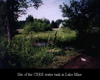
Lake Mine Station #8,
56.6 miles from Calumet
This station was formerly known
as Belt and is situated in one of the oldest copper mining districts in the Upper
Peninsula. The Lake Mine is located here and is one of the largest producers in the
district. The Alogma, North Lake and South Lake mines are also located in this vicinity.
| Building |
Type |
# of Stories |
Approx. Size |
Build Date |
Major Repair |
| Depot |
Frame |
1 |
24' x 62' |
1900 |
|
| Section house |
Frame |
2 |
20' x 28' |
1900 |
|
| Tool house |
Frame |
1 |
9' x 10' |
1900 |
|
| 2 Privies |
Frame |
1 |
Standard |
1900 |
|
| Track Scale |
Steel |
Fairbanks |
40' 100 ton |
1911 |
|
Greenland Junction
Station #5, 57.1 miles from Calumet
| Building |
Type |
# of Stories |
Approx. Size |
Build Date |
Major Repair |
| Tool house |
Frame |
1 |
9' x 10' |
|
|
McKeever Station #2,
59.2 miles from Calumet
The junction point of the
Chicago, Milwaukee & St. Paul Railway and Copper Range Railroad. One-half mile from
Mass, Mich.
| Building |
Type |
# of Stories |
Approx. Size |
Build Date |
Major Repair |
| 1/2 Depot |
Frame |
1 |
|
1907 |
|
| Car Repair Shed |
|
|
|
|
|
GREENLAND BRANCH
(FROM GREENLAND JUNCTION)
Greenland Station #7, 2.3 miles from Greenland Junction

(The Greenland Depot today, a private residence)
A thriving community of 1,100
inhabitants; the location of Adventure Copper Mining Company and the Mass Mine.
| Building |
Type |
# of Stories |
Approx. Size |
Build Date |
Major Repair |
| Depot |
Frame |
2 |
20' x 58' |
1900 |
|
| Tool house |
Frame |
1 |
9' x 10' |
1900 |
|
| Privy |
Frame |
1 |
Standard |
|
|
LAKESHORE BRANCH (FROM MILL MINE
JUNCTION)
Obenhoff Station #81, 7.9 miles from Freda
| Building |
Type |
# of Stories |
Approx. Size |
Build Date |
Major Repair |
| Shelter Shed |
Frame |
1 |
7' x 10' |
|
|
Obenhoff Shelter (ICC Sketch)
LAKESHORE BRANCH (FROM MILL MINE
JUNCTION)
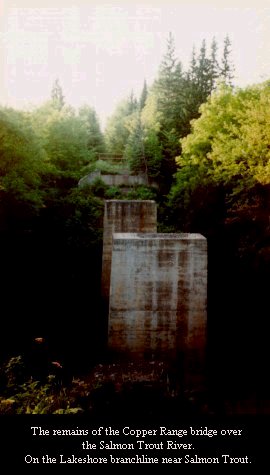
Salmon Trout Station #83, 5.3 miles from Freda
| Building |
Type |
# of Stories |
Approx. Size |
Build Date |
Major Repair |
| No Structures |
|
|
|
|
|
LAKESHORE BRANCH
Redridge Junction Station #85, 3.1 miles from Freda
| Building |
Type |
# of Stories |
Approx. Size |
Build Date |
Major Repair |
| Depot |
Frame |
1 |
12'x28'-12'x16' |
1901 |
|
| Privy |
Frame |
1 |
Standard |
|
|

Redridge Junction Depot (ICC Sketch)
REDRIDGE BRANCH (FROM REDRIDGE JUNCTION)
Redridge
Home of the Atlantic and Baltic
Mining Company's stamp mills on the shore of Lake Superior.
| Building |
Type |
# of Stories |
Approx. Size |
Build Date |
Major Repair |
| Shelter Shed |
Frame |
1 |
|
1903 |
|
| Tool house |
Frame |
1 |
|
1915 |
|
LAKESHORE BRANCH
Stanwood Station #85, 2.3 miles from Freda
| Building |
Type |
# of Stories |
Approx. Size |
Build Date |
Major Repair |
| Shelter Shed |
Frame |
1 |
12' x 16' |
|
|
LAKESHORE BRANCH
Beacon Hill Station #88, .7 miles from Freda
Home of the Trimountain Mining
Company's stamp mill on the shore of Lake Superior.
| Building |
Type |
# of Stories |
Approx. Size |
Build Date |
Major Repair |
| Depot |
Frame |
2 |
20' x 58' |
1901 |
1915-1916 |
| Privy |
Frame |
1 |
Standard |
1901 |
|
LAKESHORE BRANCH
Freda Station #89
Home of the Champion Copper
Company's stamp mill on the shore of Lake Superior.
| Building |
Type |
# of Stories |
Approx. Size |
Build Date |
Major Repair |
| Shelter Shed |
Frame |
1 |
12' x 16' |
1901 |
|
| Section house |
Frame |
1 |
16'x34'-13'x16' |
1901 |
|
| Tool house |
Frame |
1 |
9' x 10' |
1901 |
|
| Privy |
Frame |
1 |
Standard |
1901 |
|
Freda Shelter Shed (ICC Sketch)
LAKESHORE BRANCH
Freda Park 1 mile from Freda
A beautiful natural park on the
shores of Lake Superior; a popular outing point for Copper Country people and ideal for
Sunday school picnics, etc..
| Building |
Type |
# of Stories |
Approx. Size |
Build Date |
Major Repair |
| Pavilion / Kitchen |
Frame |
1 |
40'x96'-24'x40' |
1903 |
|
| Ice house |
Frame |
1 |
14' x 16' |
1907 |
|
| Baggage House |
Frame |
1 |
16' x 16' |
1908 |
|
| Custodian's house |
Frame |
1 |
18' x 20' |
1903 |
|
| 2 Privies |
Frame |
1 |
Standard |
1903 |
|
| Ice Cream Stand |
Frame |
1 |
16' x 16' |
1908 |
|
| Shelter Roof |
Frame |
1 |
416' x 10' |
|
|
List
of Under Crossings Built by the Copper Range RR.
Mainline
| No. |
Station |
Description |
Carries Track of |
Length |
Build Date |
Remarks |
| 1 |
646 |
Steel |
Mineral Range |
60' |
1902 |
Steel Towers 1913 |
| 3 |
568-41 |
Steel |
Quincy & Torch Lake |
57' |
1902 |
|
| 3.5 |
567-76 |
Wood |
Private Road |
60' |
1902 |
|
| 4 |
559-22 |
Steel |
Qunicy & Torch Lake |
98' |
1902 |
|
| 5 |
552-24 |
Wood |
Quincy & Torch Lake |
19' |
1902 |
|
| 6 |
470-85 |
Steel |
Hancock & Calumet |
20' |
1902 |
|
| 7 |
362-86 |
Steel |
Hecla & Torch Lake |
27' |
1902 |
|

Copper Range #29 Consolidation running Extra (Paul Meier Collection)
|

